User Guides › GPS field guide: Survey (Beta)
GPS field guide: Survey (Beta)
For the field: receiver setup, connecting, antenna height, collect, stakeout, COGO, exports, OPUS and the field checklist.
Contents
- What the Survey tab does
- What you need
- Setting up an Emlid Reach
- Setting up a Trimble receiver (TMM)
- Connecting, fix quality and checking in
- Projects and importing
- Recording points (Collect)
- Stakeout
- COGO
- Exports and loading into Emlid Flow / Trimble
- OPUS: static RINEX to a control point
- Troubleshooting
- One-page field checklist
- Sources (checked 2 Nov 2026)
1 · What the Survey tab does
Survey (Beta) is a pop-out panel on the ScoutTract map. It turns an RTK GNSS receiver plus your Android phone into a light data collector. You can:
- collect averaged points;
- stake out points and lines;
- run COGO;
- move files to and from Emlid Flow, Trimble Access and CAD;
- prepare OPUS static submissions and turn the emailed solution into a control point.
To open it: sign in, then tap the 📡 Survey button in the button column on the map. Or add #survey to the address.
The panel's tabs: Project · Connect · Collect · Stakeout · COGO · Points/Files · OPUS · Help.
The header buttons:
- ⚑: report a problem.
- 💡: suggest an improvement.
- ▁: minimise the panel.
- ✕: close the panel.
Your projects and points are private to your account.
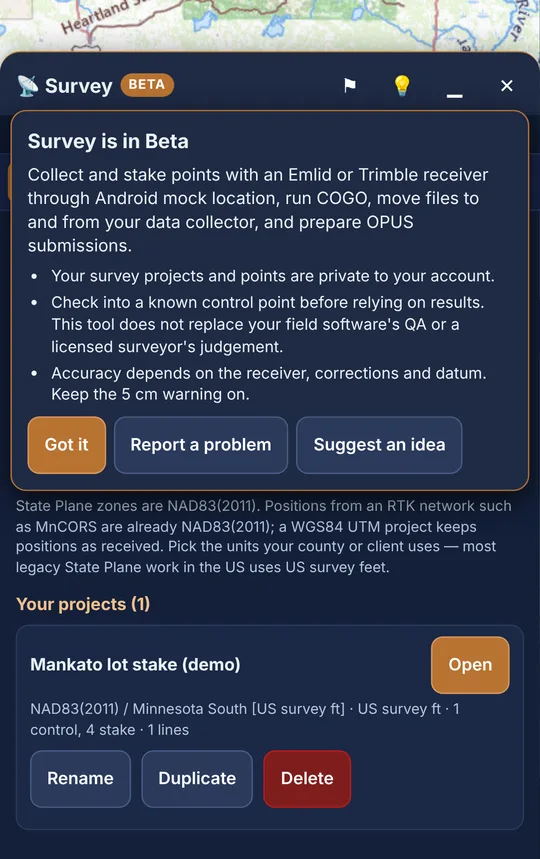
Beta: Check into a known control point before you rely on results. ScoutTract does not replace your field software's QA or a licensed surveyor's judgement.
The status bar (always visible)
The status bar shows:
- a coloured dot;
- the source, or Not connected;
- the fix, or Fix n/a;
- H and V accuracy in metres;
- satellites and PDOP, when the source reports them;
- the age of the last position in seconds;
- 📁 and the open project.
| Dot | Meaning |
|---|---|
| green | Horizontal accuracy is at or under your limit (default 0.05 m). The fix is RTK fixed, or the source doesn't report a fix. |
| amber | Accuracy is within 4× the limit, or the source doesn't report accuracy. Also amber for a fix that isn't RTK fixed (e.g. float) but whose accuracy is within the limit. |
| red | Accuracy is worse than 4× the limit. Also red for a non-fixed solution whose accuracy is worse than the limit. |
A warning line appears under the bar in these cases:
- "No position for N s — check the receiver connection." No position has arrived for more than 5 s.
- "Accuracy X m is worse than your 0.05 m limit — not survey grade."
- "Fix is RTK float — wait for RTK fixed."
- "Accuracy not reported by this source — verify on a known point."
- "Fix status unknown — confirm FIX in Lefebure/TMM." Mock location doesn't carry the fix type (see section 5).
- "Choose your receiver model on the Connect tab so the antenna phase-centre offset is right."
2 · What you need
- An Android phone or tablet with ScoutTract open in Chrome or the installed app. Mock location is an Android feature.
- One of these receivers:
- an Emlid Reach (RS2/RS2+, RS3, RS4, RX) with Emlid Flow and the Lefebure NTRIP Client app;
- a Trimble receiver (R2, R8s, R10, R12i, R580, R780, Catalyst DA2) with Trimble Mobile Manager (TMM).
- RTK corrections. These come from an NTRIP network such as MnCORS (NAD83(2011)), your own base or Trimble RTX/VRS.
- A project in the State Plane zone and units you'll deliver in.
Tip: Only one app can be Android's mock-location app at a time: Lefebure or TMM. Switch it in Developer options when you change receivers.
3 · Setting up an Emlid Reach
Emlid's route for apps that only read the phone's location goes like this [1][2]:
- The Reach streams NMEA over Bluetooth.
- Lefebure NTRIP Client reads that stream and acts as Android's mock-location app.
- ScoutTract reads the phone's location.
A. Pair the Reach and stream NMEA (in Emlid Flow)
- Connect to the Reach in Emlid Flow.
- Go to Settings → Bluetooth and turn on Discoverability.
- Pair the Reach in Android's Bluetooth settings using the unit's PIN [1].
- In Emlid Flow, go to Settings → Position streaming 1 → Bluetooth.
- Tap Edit, set Format to NMEA, and apply. Flow may ask you to join the Reach hotspot to edit streaming [1].
B. Corrections (on the receiver)
Set the NTRIP caster, mount point and login in Emlid Flow → Correction input [3]. The receiver needs internet for this. Depending on the model it gets it from:
- its own SIM or modem;
- Wi-Fi;
- the phone, if you pick Flow's "NTRIP via mobile device".
Wait for FIX in Emlid Flow before you go further.
Please note: Emlid warns that Reach gives priority to its current Bluetooth link. Disconnect any third-party Bluetooth Classic app before you use BLE in Emlid Flow [1]. In practice:
- Set things up in Flow first, then connect Lefebure.
- Prefer corrections that don't travel over the phone's Bluetooth link.
- Reach RX has no internet of its own, so its corrections come through Lefebure → NTRIP Settings over the same Bluetooth link. That's the route Emlid documents for RX. It also works as a fallback on other models; check in on a known point before you rely on it.
C. Lefebure as the mock-location app
- Install Lefebure NTRIP Client from Google Play.
- Turn on Developer options: Settings → About phone → Software information → tap Build number 7 times. The exact path varies by phone.
- Go to Settings → Developer options → Select mock location app and choose Lefebure NTRIP Client.
- In Lefebure, open ⚙ Settings → Receiver Settings and set:
- Receiver Connection: External via Bluetooth;
- Bluetooth device: your Reach;
- Bluetooth Connection Method: Secure via Reflection;
- Enable GPS Mock Locations: on [1].
- Go back and tap Connect. Check that the log shows satellites updating.
- Turn off battery optimisation (power saving) for Lefebure so Android doesn't stop it [1].
D. In ScoutTract
- Go to Connect and choose Emlid (mock location).
- Under Antenna height, pick your Receiver model (Reach RS2, RS2+, RS3, RS4, RS4 Pro or RX).
- Enter Pole height to ARP — bottom of receiver, then tap Start · Emlid (mock location).
- Reach streams positions at the antenna phase centre (APC), which sits above the bottom of the receiver (the ARP). Emlid's rule is: antenna height = height to the ARP + the APC offset [4].
- ScoutTract adds the APC offset for you. It uses the L1 offset from the NGS antenna calibration file for the model you pick, and the Connect tab shows the sum, e.g. Pole to ARP 2.000 m + ARP → APC 0.1349 m = 2.1349 m subtracted [14]. Type only the pole height.
- RS3, RS4 and RS4 Pro with tilt compensation: Emlid says to set the antenna height only in Emlid Flow; positions then arrive at the pole tip [2]. Tick Tilt compensation on. ScoutTract then subtracts nothing.
- Other antenna: choose Other — enter offset manually and type its ARP → APC offset in metres.
- Before real work: use Check in on known point on a benchmark (see section 5).
| Reach model | NGS antenna code | ARP → L1 APC |
|---|---|---|
| RS2 / RS2+ | EML_REACH_RS2 NONE / EML_REACH_RS2+ NONE | 0.1349 m |
| RS3 | EML_REACH_RS3 NONE | 0.1349 m |
| RS4 / RS4 Pro | EML_REACH_RS4 NONE / EML_REACH_RS4P NONE | 0.0937 m |
| RX | EML_REACH_RX NONE | 0.1471 m |
4 · Setting up a Trimble receiver (TMM)
On Android, Trimble Mobile Manager passes the receiver's positions to the operating system as the mock-location provider [9]. You configure the receiver itself in TMM [9][10].
- In TMM, connect the receiver. For a Catalyst DA2, sign in with your Trimble Identity [10].
- Set up the real-time corrections in TMM: Trimble RTX, VRS Now or your own NTRIP network [10].
- In TMM, open ☰ → Application settings → Share location tile → SETUP. This opens Developer options.
- Tap Select mock location app → Trimble Mobile Manager.
- Go back to TMM and turn on Share positions [11].
- Turn off battery optimisation for TMM. If you don't, Android may put it to sleep and positions stop [9].
- In ScoutTract, go to Connect and choose Trimble (mock location). Pick your Receiver model, enter Pole height to ARP — bottom of receiver, then tap Start.
- ScoutTract default: leave TMM's Apply antenna height (Configuration tab) off. In ScoutTract, enter the pole height and leave Antenna height already applied… unticked.
- No APC offset is added for Trimble. TMM reports positions at the receiver's reference point, which is usually the bottom of the receiver. For a Catalyst DA2 it's the bottom of the push-fit mount [15]. So ScoutTract subtracts the pole height only. The Connect tab shows the model's NGS offset for reference, for OPUS.
- If you'd rather TMM applies it: turn TMM's Apply antenna height on, enter the height there, and tick Antenna height already applied… in ScoutTract.
Tip: Android sometimes keeps showing the previous mock app after you pick TMM. Trimble's community says it's a display bug and sharing still works. If it doesn't, uninstall the other mock-location app.
Catalyst DA2: Accuracy depends on your subscription. Only Catalyst 1 (1–2 cm) meets the 5 cm warning.
Other sources on the Connect tab:
- Trimble TMM WebSocket (experimental): reads TMM's local stream, so you also see RTK fix, receiver model and Catalyst level. Trimble has deprecated this V1 stream.
- Bluetooth / USB NMEA (experimental, Web Serial): reads GGA/GSA/GST, so you see the real fix type. Chrome desktop only for now.
- Phone GPS: metre level, for practice only.
5 · Connecting, fix quality and checking in
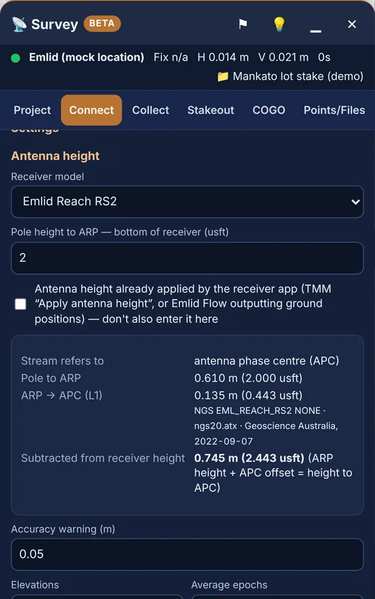
Once Start is pressed, the readout shows:
- latitude and longitude;
- Ellipsoid h;
- Fix;
- H / V accuracy;
- Sats / PDOP;
- Geoid N (GEOID18).
FIX or float?
Android mock location passes on position and accuracy only, not the fix type. With the two mock sources you'll see:
- Fix n/a in the status bar;
- "not reported by mock location" next to Fix.
So with mock location, check FIX in Emlid Flow, Lefebure or TMM before you measure. The first time you store a point in a session, ScoutTract shows "Fix status unknown — confirm FIX in Lefebure/TMM." Tap OK only if the receiver app shows FIX. You can also tap FIX confirmed in Lefebure/TMM on the Connect or Collect tab. You're asked once per session. Those points are stored with the fix RTK fixed (user-confirmed), and the accuracy limit still applies.
The TMM WebSocket and Bluetooth/USB NMEA sources report the fix themselves. With them, a point is stored as RTK only when the fix is RTK fixed. Otherwise ScoutTract asks first and stores it with its real fix (e.g. RTK float).
Settings (Connect tab)
- Accuracy warning (m): default 0.05. Points worse than this ask you to confirm. Keep it at 5 cm or tighter.
- Receiver model: sets the antenna phase-centre (APC) offset from the NGS calibration file. Emlid models add it; Trimble/TMM doesn't need it. Other — enter offset manually lets you type one.
- Pole height to ARP — bottom of receiver: in project units. The card under it shows what's subtracted: pole + APC = height to APC.
- Tilt compensation on (RS3/RS4/RS4 Pro only) and Antenna height already applied by the receiver app: see sections 3 and 4.
- Elevations:
- Orthometric NAVD88 (GEOID18): ScoutTract subtracts the NGS GEOID18 separation from the ellipsoid height (H = h − N).
- Ellipsoidal: uses the ellipsoid height as is.
- Average epochs: 1–600, default 5.
Check in on a known point (every session)
- Import or key in the control point as Control. Use Points/Files → Key in a point, or import it.
- Go to Collect. Under Check in on known point, pick the point. Control points are listed first.
- Check the tolerances: Tolerance H defaults to 0.05 m and Tolerance V to 0.08 m.
- Plumb the pole on the mark and tap Check in on known point. It averages your epochs like Measure.
- Read the result: PASS or FAIL, with dH, dV, dN and dE. If the point has no elevation, only H is checked.
- Tap Download check-in report (CSV). It lists each check-in with its deltas, tolerances, fix, accuracy, ARP height and APC offset.
Check in at the start and the end of each session. If dV is about the size of the APC offset (0.09–0.15 m) or the pole height, the receiver model or antenna-height setting is wrong.
6 · Projects and importing
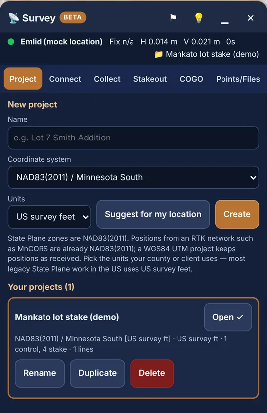
- Go to Project → New project and type a Name (e.g. "Lot 7 Smith Addition").
- Choose the Coordinate system. Suggest for my location fills the "Suggested here" list. State Plane zones are NAD83(2011), the same as MnCORS.
- Choose Units: US survey feet, International feet or Metres. Then tap Create.
- Under Your projects you can Open, Rename, Duplicate or Delete a project. To delete, you must type the project name.
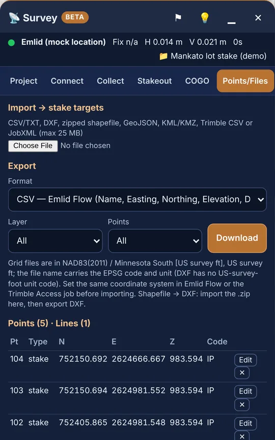
Import (Points/Files → Import → stake targets)
Choose the file. ScoutTract shows Detected: with the file type, then the options for that type.
Formats: CSV/TXT, DXF, zipped shapefile, GeoJSON, KML/KMZ, and Trimble CSV or JobXML, up to 25 MB.
CSV options:
- Layout: Auto (header names), PNEZD, PENZD, or Use the column mapping below.
- Coordinates: Grid N/E (project system) or Latitude / longitude.
- File units.
DXF options: DXF units.
Shapefile: must be zipped with its .prj. It's reprojected from the .prj.
Settings for every import:
- Import as: Stake targets, Control or Measured.
- Layer.
- Duplicate names: Rename (adds _1), Skip or Replace.
Then tap Import. DXF coordinates are read as grid coordinates in the project system.
To add a single point, use Key in a point under the point list.
7 · Recording points (Collect)
- Check the next Point number, which fills in automatically.
- Pick a Code from the list (CP, IP, IPF, IPS, BM, TOPO, EP, CL, FL, FN, BLDG, TREE, MH, HYD, UP) or type your own.
- Add a Description and choose the Type: Measured or Control.
- Hold the pole plumb and tap Measure (N epochs). The note shows "Averaging x of N epochs…". Use Cancel to stop.
- A message confirms "Stored …" with N/E, the number of epochs and the spread. The point appears in Recent (Pt, N, E, Z, Code, Fix).
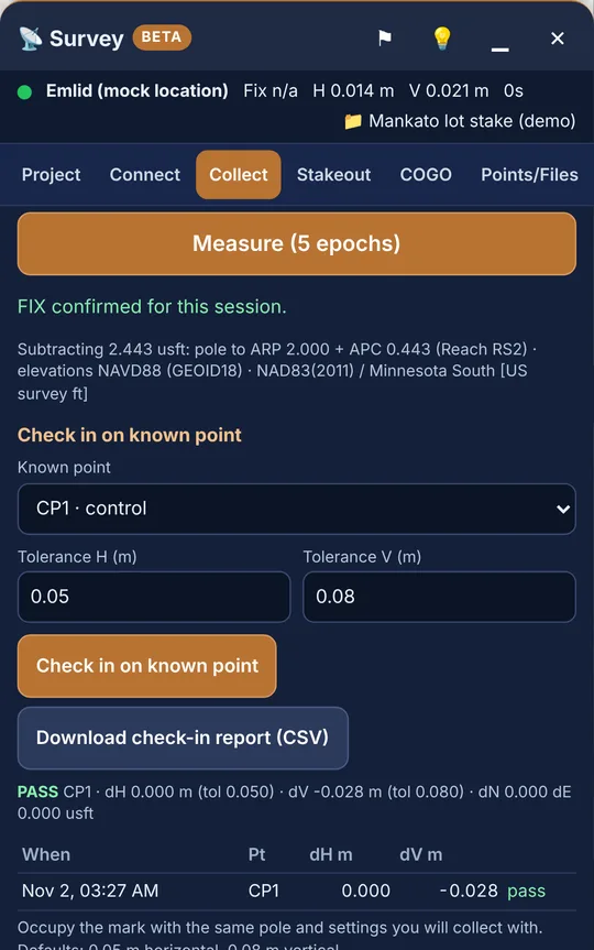
Before a point is stored:
- Mock location (Emlid, Trimble): confirm FIX once per session (see section 5). The point gets the fix RTK fixed (user-confirmed).
- TMM WebSocket / NMEA: if the reported fix isn't RTK fixed, ScoutTract asks first and stores the point with its real fix, not as RTK.
- Any source: if the accuracy is missing or worse than your limit, ScoutTract asks "Store it anyway?"
Tip: The line under the button shows what's subtracted, e.g. "Subtracting 2.135 m: pole to ARP 2.000 + APC 0.135 (Reach RS2)", or that the height is applied by the receiver app. It also shows the elevation type and coordinate system. Glance at it before every session.
8 · Stakeout
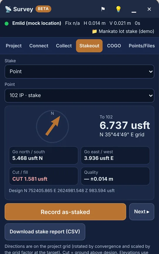
Under Stake, choose what to stake:
- Point: pick a point.
- Line station / offset: pick a line, enter Station and Offset (+R / −L), then tap Set. Next + (default 50) sets the step between stations.
- Line vertex: pick a line and enter Vertex #.
The card shows:
- To <name>, the distance and a grid bearing;
- Go north / south and Go east / west;
- Cut / fill: CUT means the ground is above design;
- Quality.
The arrow turns green within 0.1 m.
When you're on the point:
- Tap Record as-staked. It averages up to 30 epochs.
- Tap Next ▸ to move to the next target.
- At the end, tap Download stake report (CSV). It shows design and staked N/E/Z, dN/dE/dZ, the horizontal miss, cut/fill, fix, H acc, antenna height and time (UTC).
Tip: Directions are on the project grid, not true north.
9 · COGO
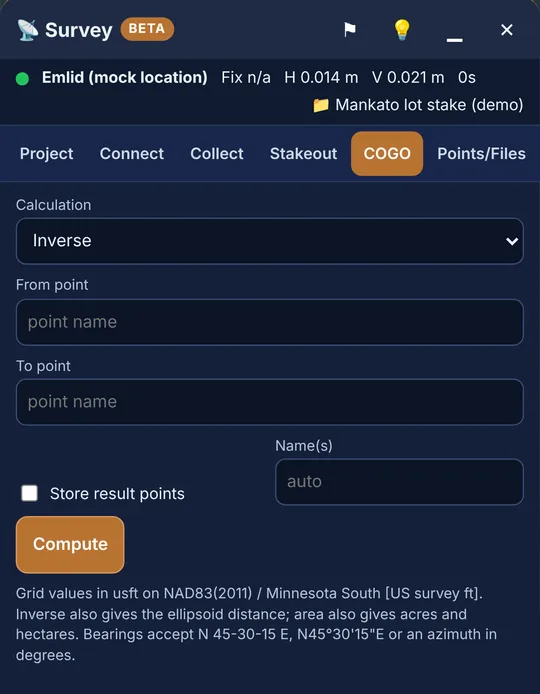
Calculations available:
- Inverse: bearing, azimuth, grid and ellipsoid distance, dN/dE, dZ, slope and grade.
- Forward (bearing & distance).
- Traverse: one "bearing, distance" leg per line, with optional Close to point. Gives the misclosure and precision.
- Intersections: bearing–bearing, distance–distance and bearing–distance.
- Station / offset of a point.
- Point at station / offset.
- Area & perimeter: square units, acres, hectares and ellipsoid area.
To store results: tick Store result points and set Name(s) (default "auto"). Then tap Compute.
Bearing formats accepted:
N 45-30-15 E;N45°30'15"E;- an azimuth in degrees.
10 · Exports and loading into Emlid Flow / Trimble
Go to Points/Files → Export. You can filter by Layer and Points (All, Measured + control, Stake, As-staked or COGO), then tap Download. The file name includes the EPSG code and units.
| Format in ScoutTract | Use it for |
|---|---|
| CSV — Emlid Flow | Emlid Flow CSV import. The header is Point,Easting,Northing,Elevation,Description,Code. Flow needs Point, Easting, Northing and Elevation headers [5]. |
| CSV — PNEZD (Trimble Access, Carlson, Civil 3D) · CSV — PENZD | Emlid Flow PNEZD/PENZD (no header) [5], Carlson, Civil 3D. |
| CSV — P,N,E,Z,Code (Trimble Access) | A Trimble Access CSV linked file. The job's Coordinate order must match [12]. |
| DXF (points, labels, linework) | CAD. Emlid Flow "DXF as geometries" [5]. Trimble Access DXF [12]. |
| Shapefile .zip with .prj | GIS. Emlid Flow shapefile (ZIP with .shp/.shx/.dbf) [5]. Trimble Access .shp [12]. |
| KML (Google Earth) | Google Earth, Emlid Flow, Trimble Access (WGS 84) [12]. |
| Trimble JobXML .jxl (experimental) | Trimble office software. Test it before relying on it. |
| CSV — full / Stake report CSV / Check-in report CSV | Records: fix, accuracy, lat/lon, stake deltas and check-in results. |
Converting a shapefile to DXF or CSV
- Import the zipped shapefile in Points/Files.
- Export it as DXF, or as any of the CSVs.
Loading into Emlid Flow
- Create the Flow project in the same coordinate system and units.
- Swipe up the project drawer and tap Import, then choose the format [5].
Loading into Trimble Access
11 · OPUS: static RINEX to a control point
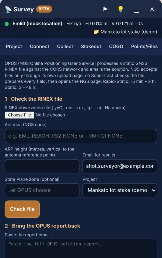
Limitation: ScoutTract doesn't log raw GNSS observations or RINEX. Mock location and NMEA carry positions only. Record the static file on the receiver, then bring it here to check.
Emlid:
- In Emlid Flow, go to Logging → Recorded logs and settings → ⚙.
- Choose the OPUS preset with RINEX 3.03.
- Enter the height to the bottom of the receiver.
- Tap Start recording. Emlid suggests at least 4 h for best accuracy.
- Tap End recording, then download the file [6].
UBX logs can be converted in Emlid Studio. For OPUS, use a 30 s interval, time rounding and GPS only [8].
Trimble: log static data on the receiver and convert it to RINEX in your office software.
1 · Check the RINEX file
- Choose the file. Accepted: .yyO, .obs, .rnx, .gz, .zip or Hatanaka.
- Enter the Antenna (NGS code), e.g.
EML_REACH_RS2 NONE(RS2+:EML_REACH_RS2+ NONE; RS4:EML_REACH_RS4 NONE) orTRMR12I NONE[7][14]. - Enter the ARP height in metres: vertical from the mark to the antenna reference point. On a Reach, that's the bottom of the receiver [4].
- Fill in Email for results, an optional State Plane zone and the Project. Then tap Check file.
ScoutTract checks:
- the duration: 15 min–2 h → OPUS-RS; 2–48 h → OPUS-S;
- midnight crossing and the logging interval;
- L1/L2 dual frequency (NGS requires dual-frequency GPS) [13];
- the antenna, the height and the file size.
When the file passes, ScoutTract shows ✓ Ready for OPUS-RS/OPUS-S with Copy buttons.
- Tap Open NGS OPUS upload ↗.
- On the NGS page, enter the data file, antenna, antenna height and email.
- Press Upload to Rapid-Static or Upload to Static [13].
2 · Bring the OPUS report back
- Paste the report email, or use …or choose the report file.
- Set the Point name and the Height: Orthometric (NAVD88) or Ellipsoidal.
- Keep Save as a control point in the project above ticked, then tap Read report.
ScoutTract checks the report against NGS guidance:
- more than 90% of observations used;
- more than 50% of ambiguities fixed;
- RMS under 3 cm;
- peak-to-peak under 5 cm.
It shows ✓ Solution meets NGS quality guidance or ! Review this solution. The saved point gets code OPUS and the type Control. NAD83 projects use the NAD_83 coordinates and WGS84 projects use ITRF. Mark each upload in History with Mark submitted.
Please note: NGS is modernising the NSRS. Its page sets a deadline of 13 Jan 2027 for OPUS Projects and levelling submissions to the current datums. Regular OPUS uploads aren't affected by that notice [13].
12 · Troubleshooting
| What you see | Try this |
|---|---|
| Positions are metre level, or the accuracy is ~3–5 m | The phone GPS is still in use. Check Developer options → Select mock location app (Lefebure or TMM). Make sure Lefebure shows Connected, or TMM Share positions is on. |
| "No position for N s" | Android put the mock app to sleep. Turn off battery optimisation for Lefebure or TMM, and keep the app running. Check the receiver's Bluetooth. |
| Fix n/a, or "Fix status unknown — confirm FIX in Lefebure/TMM" | Normal with mock location. Check FIX in Emlid Flow, Lefebure or TMM, then tap FIX confirmed. |
| Amber or red dot, "worse than your 0.05 m limit" | Wait for FIX. Check the correction age and login in Flow or TMM. Move away from canopy and buildings. |
| Elevations off by ~0.09–0.15 m (Reach) or by the pole height | Wrong receiver model or antenna-height setting, or the height is set in two places. See sections 3 and 4, then use Check in on known point. |
| Elevations off by ~30 m | Elevations is set to the wrong type: ellipsoidal vs NAVD88. Match your deliverable. |
| Emlid Flow can't connect while Lefebure runs | Reach gives priority to one Bluetooth link. In Lefebure, tap Disconnect, make your changes in Flow, then reconnect [1]. |
| Android won't keep TMM as the mock app | This is a display bug and sharing usually still works. If not, uninstall the other mock app. |
| Import lands in the wrong place | Check Coordinates (grid vs lat/lon), File units, the PNEZD vs PENZD order, and that the shapefile .zip has its .prj. |
| Emlid Flow rejects the CSV | Use CSV — Emlid Flow with Flow's CSV import, or PNEZD with Flow's PNEZD import. |
| OPUS check fails | Single-frequency data, an interval OPUS doesn't accept, or a file under 15 min or over 48 h. For Reach, re-convert in Emlid Studio (30 s, GPS only). |
| Something else | Tap ⚑ in the Survey header to report a problem. It goes to the ScoutTract team. |
13 · One-page field checklist
Before you leave
- Phone and receiver charged; ScoutTract signed in
- Project open: right zone, units and elevation type
- Control and stake targets imported (Stake targets / Control)
- NTRIP login and mount point saved in Flow or TMM
- Pole height to the bottom of the receiver measured and written down
At the truck
- Mock location app = Lefebure (Emlid) or TMM (Trimble)
- Battery optimisation off for that app
- Emlid: Bluetooth Discoverability on, Reach paired; Position streaming 1 = Bluetooth NMEA; Lefebure Connected
- Trimble: Share positions on; receiver model chosen
- Receiver shows FIX in Flow, Lefebure or TMM
In ScoutTract (Connect)
- Correct source, then Start; green dot
- Accuracy warning 0.05 m (or tighter)
- Receiver model chosen; card shows pole + APC
- Antenna height set in one place only
- Reach: pole to ARP here, box off
- RS3/RS4 tilt: Flow only, Tilt on
- TMM: here, TMM Apply off
- FIX confirmed once (mock location)
- Average epochs set (5+ for control)
Work
- Check in on known point (Collect): PASS within 0.05 m H / 0.08 m V
- Collect with Measure; don't override "Store it anyway?" without a reason
- Stake, Record as-staked, then Next ▸
- Check in again at the end
- Download the check-in report, stake report and exports
Tolerance reminder: the arrow turns green within 0.1 m. Your tolerance is your own call.
Sources (checked 2 Nov 2026)
- Emlid, "Getting Reach coordinates on Android via BT" (Reach RS2/RS2+). docs.emlid.com/reachrs2/integration/mock-location/
- Emlid, mock-location guide for Reach RS3. docs.emlid.com/reachrs3/integration/mock-location/
- Emlid, RTK over NTRIP (RS2: docs.emlid.com/reachrs2/rtk-quickstart/ntrip-workflow/; RS3: …/reachrs3-as-rover/rtk-over-ntrip-service/)
- Emlid, "How to set up antenna height for RTK". docs.emlid.com/reachrs2/rtk-quickstart/antenna-height-rtk/
- Emlid Flow, "Create or import project". docs.emlid.com/emlid-flow/setting-up-team-and-projects/creating-project/
- Emlid, "How to log data for OPUS". docs.emlid.com/reachrs2/ppk-quickstart/how-to-record-and-download-logs/opus-logging/
- Emlid, "NOAA's OPUS" workflow. docs.emlid.com/reachrs2/base-setup/determining-base-position/online-post-processing-services/opus-workflow/
- Emlid Studio, "Convert to RINEX". docs.emlid.com/emlid-studio/convert-to-rinex-workflow/
- Trimble Mobile Manager help, "Location sharing with other apps". help.fieldsystems.trimble.com/trimble-mobile-manager/location-sharing.htm
- Trimble Mobile Manager help, "Get started". help.fieldsystems.trimble.com/trimble-mobile-manager/get-started.htm
- Ultimate Positioning Group (Trimble dealer), "Location Sharing". help.upgsolutions.com/hc/en-au/articles/7494420755087
- Trimble Access help, "Point and line files". help.fieldsystems.trimble.com/trimble-access/latest/en/data-files-points-lines.htm
- NGS, OPUS upload page. www.ngs.noaa.gov/OPUS/
- NGS, antenna calibrations file ngs20.atx (G01 north/east/up, radome NONE): EML_REACH_RS2/RS2+/RS3 134.92 mm, RS4/RS4P 93.72 mm, RX 147.08 mm; TRMDA2 53.66, TRMR2 91.16, TRMR10 128.36, TRMR10-2 128.64, TRMR12 128.75, TRMR12I 129.32 mm. geodesy.noaa.gov/ANTCAL/ (files.ngs.noaa.gov/pub/antcal/)
- Trimble Mobile Manager help, "Configure the antenna height". help.fieldsystems.trimble.com/trimble-mobile-manager/antenna-height.htm
ScoutTract Survey is in Beta. Results depend on your receiver, corrections, datum and setup. This guide doesn't replace your field software's QA or a licensed surveyor's judgement.