
Welcome to ScoutTract
ScoutTract puts land, mineral, geology and water research on one map. This guide walks you through the pilot, one short step at a time.
Getting started
ScoutTract is invite-only during the pilot. Your trial lasts 30 days from the day you accept your invite. No payment details are needed and the trial simply ends on its own.
Accept your invite
- Open the private link in your invite email or text. It works once and expires after a couple of weeks.
- Fill in your name and organization. Job title and phone are optional.
- Set a password of at least 12 characters.
- Accept the terms: tick the box for the Terms of Service, Privacy Policy and Data Disclaimer, then press Create my trial account.
- You are signed in straight away. Next time, sign in with your email and password.
Tip: If we update the terms later, the app asks you to accept the new version once before you continue.
Pick a state
- Open States (◎) in the left rail. On a phone it is under More.
- Choose your research state. You see the states your invite covers.
- The map jumps to that state and the layer list switches to that state’s data.
Pilot states: Minnesota, North Dakota, Colorado, Texas, Iowa, Arizona, Montana, Wyoming, Nebraska, New Mexico, Utah, North Carolina. Each state has different public data, so the layers differ from state to state.
Find your way around
- Explore (▦): the main map and layers.
- Geology (◫): geology, well logs, sections and the 3D viewer.
- CAD/Survey (✎): project drawings and DXF files.
- Projects (▧), Reports (▣), Records (▤), Tasks (◷), Land (⌂), Mining (◉), Settings (⚙) and Feedback (✉).
- Drone/ODM (◉) is under maintenance during the pilot. About (ⓘ) tells you about the app.
- The ? Guide button at the top of the app opens this page.
On a big screen the app opens in the map-first layout: the map fills the window and tools open as floating windows from the bar on the map: Layers ▦ (area and parcel settings), Catalog ☰ (the full layer list), Search ⌕ (parcel search), Draw ✎ and Map ⚙. You can drag, dock or close them (Esc closes the top one). Prefer the older side-panel view? Press Classic layout at the top right; press Map-first layout to switch back. Your choice is remembered.
The map
Zoom readout
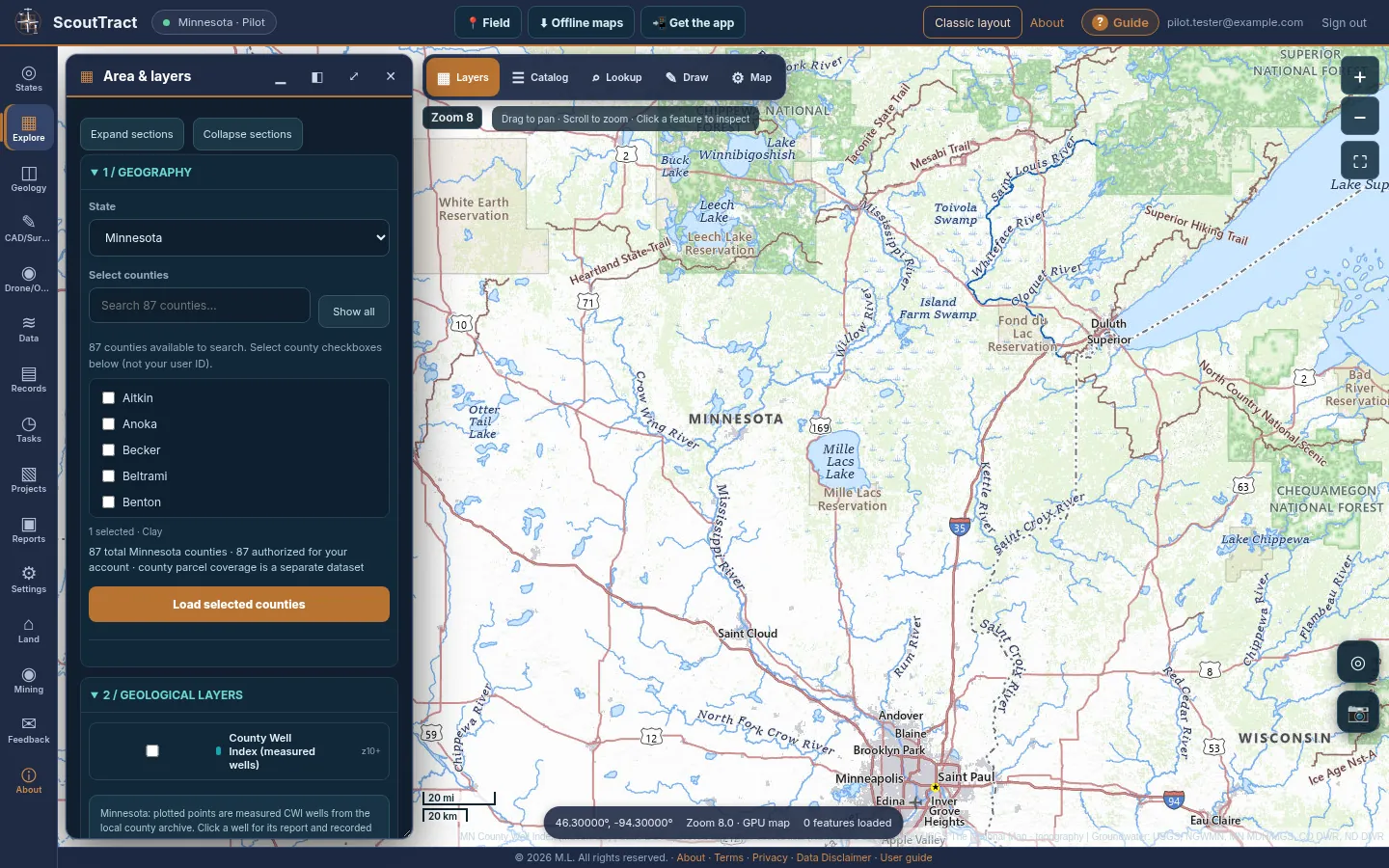
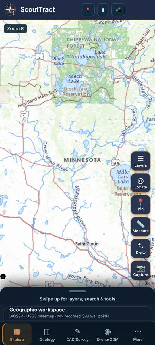
The badge on the map shows the current zoom, for example Zoom 9, with a scale bar in feet or miles. Bigger numbers are closer in. Many layers only load once you are zoomed in far enough, so you do not wait for data you cannot see.
- A layer that needs more zoom is greyed out and says zoom in to N (now M).
- State data layers show from zN under their name.
- Other map tools: drag the handle under the map to resize it, and use the full-screen button to give the map the whole screen.
Layers
- Open the layer list: Catalog (☰) on the map bar, the Map layers card in the classic layout, or the Layers button on a phone.
- Type in the search box to filter every group at once.
- Tick a layer to turn it on. Some layers have an opacity slider and a legend.
- Click a feature on the map to see its details and a link to the official source.
Groups: Hazards & federal reference layers, FEMA flood hazard, State data layers, Historical mines & DOT sources, Groundwater & water wells, Colorado-only portal and BLM catalog layers, and Your layers & services (your own files or map services).
Tip: If a layer is on but nothing draws, zoom in one more step. Some layers also stop at a maximum number of features; zoom in to see them all.
When each layer appears
The tables are built from the app’s own layer settings. “Shows from zoom” is the number the app shows next to the layer.
Minnesota (MN) · 25 layers
| Shows from zoom | Layer | Group |
|---|---|---|
| 4 | County Well Index (measured wells) | Core layers |
| 4 | Precomputed regional 3D surface tiles | Core layers |
| 5 | Bedrock surface elevation (MGS D-04, 2025) | Minnesota Geological Survey (MGS) |
| 5 | Depth to bedrock (MGS D-03, 2025) | Minnesota Geological Survey (MGS) |
| 7 | Recorded borehole stratigraphy | Core layers |
| 7 | DNR mineral potential projects | MN DNR Lands & Minerals |
| 7 | Crude oil trunk pipelines (EIA) | MN Utilities (approximate - call 811) |
| 7 | Electric retail service territories (HIFLD) | MN Utilities (approximate - call 811) |
| 7 | Electric transmission lines (HIFLD) | MN Utilities (approximate - call 811) |
| 7 | Electric utility service areas (MN Commerce / MnGeo) | MN Utilities (approximate - call 811) |
| 7 | Hydrocarbon gas liquids pipelines (EIA) | MN Utilities (approximate - call 811) |
| 7 | Natural gas pipelines, interstate & intrastate (EIA) | MN Utilities (approximate - call 811) |
| 7 | Petroleum product pipelines (EIA) | MN Utilities (approximate - call 811) |
| 7 | Power plants (EIA-860) | MN Utilities (approximate - call 811) |
| 8 | Lehmann exploration collection areas | MN DNR Lands & Minerals |
| 8 | Mineral exploration document archive (areas, points, maps) | MN DNR Lands & Minerals |
| 8 | State metallic mineral leases (active) | MN DNR Lands & Minerals |
| 8 | State metallic mineral leases (historic) | MN DNR Lands & Minerals |
| 8 | State peat leases (active) | MN DNR Lands & Minerals |
| 8 | Wastewater treatment plants (EPA ICIS-NPDES) | MN Utilities (approximate - call 811) |
| 9 | Drill core library boring locations | MN DNR Lands & Minerals |
| 9 | Community water system service areas (EPA) | MN Utilities (approximate - call 811) |
| 9 | Lidar hillshade (2nd generation) | MN elevation |
| 10 | PLSS townships & sections (Fourth and Fifth Principal Meridians) | Core layers |
| 12 | Parcel lines (MnGeo open statewide parcels, opt-in counties) | MN parcels |
North Dakota (ND) · 38 layers
| Shows from zoom | Layer | Group |
|---|---|---|
| 4 | County boundaries | Core layers |
| 5 | Bedrock geology | Core layers |
| 5 | Bedrock geology (NDGS) | ND Geological Survey (NDGS) geology |
| 6 | State parks | Core layers |
| 6 | Surface geology (NDGS) | ND Geological Survey (NDGS) geology |
| 7 | DWR water-well drillers logs (imported) | Core layers |
| 7 | State and federal roads | Core layers |
| 7 | Surficial geology | Core layers |
| 7 | Glacial landforms & landslides (NDGS) | ND Geological Survey (NDGS) geology |
| 7 | Active rigs | ND Oil & Gas Division |
| 7 | Crude oil trunk pipelines (EIA) | ND Utilities (approximate - call 811) |
| 7 | Electric retail service territories (HIFLD) | ND Utilities (approximate - call 811) |
| 7 | Electric transmission lines (HIFLD) | ND Utilities (approximate - call 811) |
| 7 | Gas processing plants (ND DMR) | ND Utilities (approximate - call 811) |
| 7 | Hydrocarbon gas liquids pipelines (EIA) | ND Utilities (approximate - call 811) |
| 7 | Natural gas pipelines, interstate & intrastate (EIA) | ND Utilities (approximate - call 811) |
| 7 | Petroleum product pipelines (EIA) | ND Utilities (approximate - call 811) |
| 7 | Power plants (EIA-860) | ND Utilities (approximate - call 811) |
| 7 | Rural water districts (ND GIS Hub) | ND Utilities (approximate - call 811) |
| 8 | Abandoned mines | Core layers |
| 8 | Mapped aquifers | Core layers |
| 8 | Wildlife management areas | Core layers |
| 8 | State trust lands (surface) | ND Dept. of Trust Lands |
| 8 | Seismic 3D survey areas | ND Oil & Gas Division |
| 8 | Seismic survey outlines (2D lines + 3D areas) | ND Oil & Gas Division |
| 8 | Wastewater treatment plants (EPA ICIS-NPDES) | ND Utilities (approximate - call 811) |
| 9 | Drilling spacing units (Bakken) | ND Oil & Gas Division |
| 9 | Permits (before spud) | ND Oil & Gas Division |
| 9 | Unit boundaries | ND Oil & Gas Division |
| 9 | Community water system service areas (EPA) | ND Utilities (approximate - call 811) |
| 10 | GLO / DWR survey document index | Core layers |
| 10 | PLSS sections | Core layers |
| 10 | Directional wellbores | ND Oil & Gas Division |
| 10 | Horizontal wellbores | ND Oil & Gas Division |
| 10 | Oil & gas wells (all) | ND Oil & Gas Division |
| 12 | PLSS section corners | Core layers |
| 12 | USFWS NWI wetland polygons | Core layers |
| 13 | Parcel boundaries | Core layers |
Colorado (CO) · 25 layers
| Shows from zoom | Layer | Group |
|---|---|---|
| 7 | Oil & gas fields | CO ECMC (more oil & gas) |
| 7 | Crude oil trunk pipelines (EIA) | CO Utilities (approximate - call 811) |
| 7 | Electric retail service territories (HIFLD) | CO Utilities (approximate - call 811) |
| 7 | Electric transmission lines (HIFLD) | CO Utilities (approximate - call 811) |
| 7 | Electric utility territories (CDOT) | CO Utilities (approximate - call 811) |
| 7 | Hydrocarbon gas liquids pipelines (EIA) | CO Utilities (approximate - call 811) |
| 7 | Natural gas pipelines, interstate & intrastate (EIA) | CO Utilities (approximate - call 811) |
| 7 | Petroleum product pipelines (EIA) | CO Utilities (approximate - call 811) |
| 7 | Power plants (EIA-860) | CO Utilities (approximate - call 811) |
| 8 | SLB solid-mineral evaluations (industrial, metals, coal – CGS) | CO State Land Board |
| 8 | Wastewater treatment plants (EPA ICIS-NPDES) | CO Utilities (approximate - call 811) |
| 9 | SLB mineral estate | CO State Land Board |
| 9 | SLB oil & gas leases (as-built) | CO State Land Board |
| 9 | SLB surface ownership | CO State Land Board |
| 9 | Community water system service areas (EPA) | CO Utilities (approximate - call 811) |
| 10 | Drilling & location permits | CO ECMC (more oil & gas) |
| 10 | ECMC oil/gas well locations (not CWI boreholes) | Core layers |
| 11 | Directional survey lines & bottomholes | CO ECMC (more oil & gas) |
| 11 | ECMC land grid (township/section/QQ) | CO ECMC (more oil & gas) |
| 11 | Facilities & pits | CO ECMC (more oil & gas) |
| 11 | Wellbores | CO ECMC (more oil & gas) |
| 11 | SLB rights-of-way | CO State Land Board |
| 12 | Water-well permits (DWR API, near map centre) | CO Division of Water Resources |
| 12 | Oil & gas flowlines (ECMC) | CO Utilities (approximate - call 811) |
| 15 | Official public parcel boundaries | Core layers |
Texas (TX) · 18 layers
| Shows from zoom | Layer | Group |
|---|---|---|
| 7 | Crude oil trunk pipelines (EIA) | TX Utilities (approximate - call 811) |
| 7 | Electric retail service territories (HIFLD) | TX Utilities (approximate - call 811) |
| 7 | Electric transmission lines (HIFLD) | TX Utilities (approximate - call 811) |
| 7 | Hydrocarbon gas liquids pipelines (EIA) | TX Utilities (approximate - call 811) |
| 7 | Natural gas pipelines, interstate & intrastate (EIA) | TX Utilities (approximate - call 811) |
| 7 | Petroleum product pipelines (EIA) | TX Utilities (approximate - call 811) |
| 7 | Power plants (EIA-860) | TX Utilities (approximate - call 811) |
| 8 | Sewer CCN service areas (PUCT) | TX Utilities (approximate - call 811) |
| 8 | Wastewater treatment plants (EPA ICIS-NPDES) | TX Utilities (approximate - call 811) |
| 8 | Water CCN service areas (PUCT) | TX Utilities (approximate - call 811) |
| 9 | Community water system service areas (EPA) | TX Utilities (approximate - call 811) |
| 9 | Water CCN facility lines (PUCT) | TX Utilities (approximate - call 811) |
| 10 | RRC pipelines | TX RRC oil & gas |
| 10 | RRC pipelines (T-4 permitted, all types) | TX Utilities (approximate - call 811) |
| 12 | Original Texas Land Survey (abstract / survey / block / section) | Core layers |
| 12 | Original Texas Land Survey tracts (with abstract & survey labels) | TX land survey (abstract / survey / block / section) |
| 13 | RRC well locations | TX RRC oil & gas |
| 14 | StratMap land parcels (appraisal districts) | TX parcels (TxGIO StratMap) |
Iowa (IA) · 23 layers
| Shows from zoom | Layer | Group |
|---|---|---|
| 7 | Crude oil trunk pipelines (EIA) | IA Utilities (approximate - call 811) |
| 7 | Electric retail service territories (HIFLD) | IA Utilities (approximate - call 811) |
| 7 | Electric transmission lines (HIFLD) | IA Utilities (approximate - call 811) |
| 7 | Hydrocarbon gas liquids pipelines (EIA) | IA Utilities (approximate - call 811) |
| 7 | Natural gas pipelines, interstate & intrastate (EIA) | IA Utilities (approximate - call 811) |
| 7 | Petroleum product pipelines (EIA) | IA Utilities (approximate - call 811) |
| 7 | Power plants (EIA-860) | IA Utilities (approximate - call 811) |
| 7 | Bedrock faults | IA geology (Iowa Geological Survey) |
| 7 | Bedrock geology (1:500k / 1:100k) | IA geology (Iowa Geological Survey) |
| 7 | Depth to bedrock (raster) | IA geology (Iowa Geological Survey) |
| 8 | Electrical service boundaries (Iowa Utilities Commission) | IA Utilities (approximate - call 811) |
| 8 | Wastewater treatment plants (EPA ICIS-NPDES) | IA Utilities (approximate - call 811) |
| 9 | Community water system service areas (EPA) | IA Utilities (approximate - call 811) |
| 9 | Karst features (sinkholes, potential karst) | IA geology (Iowa Geological Survey) |
| 9 | Historic coal mines (IGS) | IA mines & quarries |
| 9 | Public lands (federal, state, county) | IA public lands |
| 10 | Bedrock surface topography contours | IA geology (Iowa Geological Survey) |
| 10 | Quarries, sand & gravel and asphalt/concrete sites (DNR stormwater General Permit #3) | IA mines & quarries |
| 11 | PLSS townships & sections (Fifth Principal Meridian) | Core layers |
| 11 | Surficial (Quaternary) geology | IA geology (Iowa Geological Survey) |
| 12 | All wells (IGS GeoSam, private, public, abandoned) | IA wells (GeoSam / DNR) |
| 12 | IGS stratigraphic data points | IA wells (GeoSam / DNR) |
| 15 | Parcels (Iowa statewide 2017 snapshot, not current) | IA public lands |
Arizona (AZ) · 22 layers
| Shows from zoom | Layer | Group |
|---|---|---|
| 7 | Crude oil trunk pipelines (EIA) | AZ Utilities (approximate - call 811) |
| 7 | Electric retail service territories (HIFLD) | AZ Utilities (approximate - call 811) |
| 7 | Electric transmission lines (HIFLD) | AZ Utilities (approximate - call 811) |
| 7 | Hydrocarbon gas liquids pipelines (EIA) | AZ Utilities (approximate - call 811) |
| 7 | Natural gas pipelines, interstate & intrastate (EIA) | AZ Utilities (approximate - call 811) |
| 7 | Petroleum product pipelines (EIA) | AZ Utilities (approximate - call 811) |
| 7 | Power plants (EIA-860) | AZ Utilities (approximate - call 811) |
| 7 | Active mines, quarries & aggregate plants | AZ mines, quarries & aggregate plants (AZGS) |
| 8 | Community water system service areas (ADWR) | AZ Utilities (approximate - call 811) |
| 8 | Wastewater treatment plants (EPA ICIS-NPDES) | AZ Utilities (approximate - call 811) |
| 8 | Quaternary active faults | AZ geology (Arizona Geological Survey) |
| 8 | Land ownership (ASLD public/private) | AZ land & parcels |
| 9 | Community water system service areas (EPA) | AZ Utilities (approximate - call 811) |
| 9 | Geologic map units (Geologic Map of Arizona) | AZ geology (Arizona Geological Survey) |
| 9 | State Trust land parcels (ASLD) | AZ land & parcels |
| 10 | Mapped earth fissures | AZ geology (Arizona Geological Survey) |
| 11 | ADWR GWSI groundwater sites (water levels) | AZ wells (ADWR) |
| 11 | PLSS townships & sections (Gila and Salt River / Navajo / San Bernardino meridians) | Core layers |
| 14 | Pima County regional parcels | AZ land & parcels |
| 14 | Pinal County tax parcels | AZ land & parcels |
| 14 | ADWR Wells 55 registry | AZ wells (ADWR) |
| 15 | Maricopa County parcels (Assessor) | AZ land & parcels |
Montana (MT) · 22 layers
| Shows from zoom | Layer | Group |
|---|---|---|
| 7 | Geologic map units (MBMG 1:500,000) | Geology (MBMG) |
| 7 | Quaternary faults (MBMG) | Geology (MBMG) |
| 7 | Crude oil trunk pipelines (EIA) | MT Utilities (approximate - call 811) |
| 7 | Electric retail service territories (HIFLD) | MT Utilities (approximate - call 811) |
| 7 | Electric transmission lines (HIFLD) | MT Utilities (approximate - call 811) |
| 7 | Hydrocarbon gas liquids pipelines (EIA) | MT Utilities (approximate - call 811) |
| 7 | Natural gas pipelines, interstate & intrastate (EIA) | MT Utilities (approximate - call 811) |
| 7 | Petroleum product pipelines (EIA) | MT Utilities (approximate - call 811) |
| 7 | Power plants (EIA-860) | MT Utilities (approximate - call 811) |
| 7 | Rural electric co-op service areas (State of Montana) | MT Utilities (approximate - call 811) |
| 8 | Wastewater treatment plants (EPA ICIS-NPDES) | MT Utilities (approximate - call 811) |
| 8 | Abandoned and inactive mines (MBMG AIM) | Mines and aggregate |
| 8 | Hard rock mining operating permits (DEQ, active) | Mines and aggregate |
| 8 | Opencut (sand, gravel, aggregate) mining sites (DEQ) | Mines and aggregate |
| 9 | Conservation easements (Montana Cadastral) | Land and parcels |
| 9 | Public lands (Montana Cadastral) | Land and parcels |
| 9 | Community water system service areas (EPA) | MT Utilities (approximate - call 811) |
| 9 | Abandoned mine land areas (DEQ AML) | Mines and aggregate |
| 10 | Oil and gas wells (MBOGC) | Wells |
| 11 | PLSS townships & sections (Principal Meridian Montana) | Core layers |
| 12 | Groundwater wells (MBMG GWIC) | Wells |
| 13 | Parcels (Montana Cadastral, statewide) | Land and parcels |
Wyoming (WY) · 24 layers
| Shows from zoom | Layer | Group |
|---|---|---|
| 7 | Bedrock geology (WSGS 1:500,000) | Geology (WSGS) |
| 7 | Faults (WSGS 1:500,000) | Geology (WSGS) |
| 7 | Quaternary faults (WSGS) | Geology (WSGS) |
| 7 | Crude oil trunk pipelines (EIA) | WY Utilities (approximate - call 811) |
| 7 | Electric retail service territories (HIFLD) | WY Utilities (approximate - call 811) |
| 7 | Electric transmission lines (HIFLD) | WY Utilities (approximate - call 811) |
| 7 | Gas processing plants (WSGS) | WY Utilities (approximate - call 811) |
| 7 | Hydrocarbon gas liquids pipelines (EIA) | WY Utilities (approximate - call 811) |
| 7 | Natural gas pipelines, interstate & intrastate (EIA) | WY Utilities (approximate - call 811) |
| 7 | Oil refineries (WSGS) | WY Utilities (approximate - call 811) |
| 7 | Petroleum product pipelines (EIA) | WY Utilities (approximate - call 811) |
| 7 | Power plants (EIA-860) | WY Utilities (approximate - call 811) |
| 8 | County government pits (aggregate, DEQ) | Mines and aggregate |
| 8 | DEQ mine permits and licenses (LQD) | Mines and aggregate |
| 8 | Limited mining operations (small pits, DEQ) | Mines and aggregate |
| 8 | Mines and prospects (WSGS 2018 compilation, incomplete) | Mines and aggregate |
| 8 | USGS USMIN mine sites and areas | Mines and aggregate |
| 8 | Wastewater treatment plants (EPA ICIS-NPDES) | WY Utilities (approximate - call 811) |
| 9 | State mineral leases (active) | Land and parcels |
| 9 | Community water system service areas (EPA) | WY Utilities (approximate - call 811) |
| 10 | Oil and gas wells (WOGCC) | Wells |
| 11 | PLSS townships & sections (Sixth Principal Meridian / Wind River Meridian) | Core layers |
| 12 | Groundwater wells (State Engineer permits) | Wells |
| 13 | Parcels (statewide 2024, OSLI) | Land and parcels |
Nebraska (NE) · 16 layers
| Shows from zoom | Layer | Group |
|---|---|---|
| 7 | Ogallala Group extent (CSD) | Geology |
| 7 | Topographic regions (CSD) | Geology |
| 7 | Crude oil trunk pipelines (EIA) | NE Utilities (approximate - call 811) |
| 7 | Electric retail service territories (HIFLD) | NE Utilities (approximate - call 811) |
| 7 | Electric transmission lines (HIFLD) | NE Utilities (approximate - call 811) |
| 7 | Hydrocarbon gas liquids pipelines (EIA) | NE Utilities (approximate - call 811) |
| 7 | Natural gas pipelines, interstate & intrastate (EIA) | NE Utilities (approximate - call 811) |
| 7 | Petroleum product pipelines (EIA) | NE Utilities (approximate - call 811) |
| 7 | Power plants (EIA-860) | NE Utilities (approximate - call 811) |
| 7 | Depth to groundwater (UNL) | Wells and groundwater |
| 8 | Wastewater treatment plants (EPA ICIS-NPDES) | NE Utilities (approximate - call 811) |
| 9 | Bedrock geology (USGS State Geologic Map Compilation) | Geology |
| 9 | Community water system service areas (EPA) | NE Utilities (approximate - call 811) |
| 11 | PLSS townships & sections (Sixth Principal Meridian) | Core layers |
| 12 | Registered groundwater wells (NeDNR) | Wells and groundwater |
| 13 | Parcels (statewide, Nebraska GIS) | Land and parcels |
New Mexico (NM) · 23 layers
| Shows from zoom | Layer | Group |
|---|---|---|
| 7 | Geologic map units (State Geologic Map 1:500,000) | Geology (NMBGMR) |
| 7 | Spanish and Mexican land grants (NMSLO) | Land, leases and grants |
| 7 | Mining districts (metals, industrial minerals, uranium) | Mines and minerals |
| 7 | Potash leasing areas (NMBGMR) | Mines and minerals |
| 7 | Crude oil trunk pipelines (EIA) | NM Utilities (approximate - call 811) |
| 7 | Electric retail service territories (HIFLD) | NM Utilities (approximate - call 811) |
| 7 | Electric transmission lines (HIFLD) | NM Utilities (approximate - call 811) |
| 7 | Hydrocarbon gas liquids pipelines (EIA) | NM Utilities (approximate - call 811) |
| 7 | Natural gas pipelines, interstate & intrastate (EIA) | NM Utilities (approximate - call 811) |
| 7 | Petroleum product pipelines (EIA) | NM Utilities (approximate - call 811) |
| 7 | Power plants (EIA-860) | NM Utilities (approximate - call 811) |
| 8 | Faults (structure and Quaternary, NMBGMR) | Geology (NMBGMR) |
| 8 | State trust lands (NMSLO) | Land, leases and grants |
| 8 | Registered mines (EMNRD MMD) | Mines and minerals |
| 8 | Uranium deposits and mills (NMBGMR) | Mines and minerals |
| 8 | OCD pipeline, compressor & gas plant facilities | NM Utilities (approximate - call 811) |
| 8 | Wastewater treatment plants (EPA ICIS-NPDES) | NM Utilities (approximate - call 811) |
| 9 | Community water system service areas (EPA) | NM Utilities (approximate - call 811) |
| 11 | PLSS townships & sections (New Mexico Principal Meridian) | Core layers |
| 11 | State Land Office mineral and oil and gas leases | Land, leases and grants |
| 11 | Oil and gas wells (OCD) | Wells |
| 15 | County parcels 2025 (OSE statewide compilation) | Land, leases and grants |
| 15 | Water wells / points of diversion (OSE) | Wells |
Utah (UT) · 22 layers
| Shows from zoom | Layer | Group |
|---|---|---|
| 7 | Geologic map units (UGS 1:500,000) | Geology (UGS) |
| 7 | Quaternary faults (UGS) | Geology (UGS) |
| 7 | Mining districts (UGS) | Mines and minerals |
| 7 | Crude oil trunk pipelines (EIA) | UT Utilities (approximate - call 811) |
| 7 | Electric retail service territories (HIFLD) | UT Utilities (approximate - call 811) |
| 7 | Electric transmission lines (HIFLD) | UT Utilities (approximate - call 811) |
| 7 | Electrical service providers (UGRC) | UT Utilities (approximate - call 811) |
| 7 | Hydrocarbon gas liquids pipelines (EIA) | UT Utilities (approximate - call 811) |
| 7 | Natural gas pipelines, interstate & intrastate (EIA) | UT Utilities (approximate - call 811) |
| 7 | Petroleum product pipelines (EIA) | UT Utilities (approximate - call 811) |
| 7 | Power plants (EIA-860) | UT Utilities (approximate - call 811) |
| 8 | Trust Lands mineral ownership (SITLA) | Land and parcels |
| 8 | Trust Lands surface ownership (SITLA) | Land and parcels |
| 8 | Mineral occurrences (UGS UMOS) | Mines and minerals |
| 8 | Culinary water service areas (Utah Water Rights) | UT Utilities (approximate - call 811) |
| 8 | Wastewater treatment plants (EPA ICIS-NPDES) | UT Utilities (approximate - call 811) |
| 9 | Trust Lands sand and gravel contracts (aggregate) | Mines and minerals |
| 9 | Community water system service areas (EPA) | UT Utilities (approximate - call 811) |
| 11 | PLSS townships & sections (Salt Lake Meridian / Uintah Special Meridian) | Core layers |
| 11 | Oil and gas wells (DOGM) | Wells and water rights |
| 12 | Water rights points of diversion (wells, springs) | Wells and water rights |
| 15 | Parcels (UGRC statewide) | Land and parcels |
North Carolina (NC) · 23 layers
| Shows from zoom | Layer | Group |
|---|---|---|
| 7 | Crude oil trunk pipelines (EIA) | NC Utilities (approximate - call 811) |
| 7 | Electric retail service territories (HIFLD) | NC Utilities (approximate - call 811) |
| 7 | Electric transmission lines (HIFLD) | NC Utilities (approximate - call 811) |
| 7 | Hydrocarbon gas liquids pipelines (EIA) | NC Utilities (approximate - call 811) |
| 7 | Natural gas pipelines, interstate & intrastate (EIA) | NC Utilities (approximate - call 811) |
| 7 | Petroleum product pipelines (EIA) | NC Utilities (approximate - call 811) |
| 7 | Power plants (EIA-860) | NC Utilities (approximate - call 811) |
| 7 | Oil and gas exploration wells (NCGS, 129 wells) | Wells |
| 8 | Mineral occurrences and prospects (NC MRDS, NCGS) | Mines and aggregate |
| 8 | Mining permits (DEMLR, active and released) | Mines and aggregate |
| 8 | NCDOT aggregate sources (coarse and fine aggregate suppliers) | Mines and aggregate |
| 8 | Type A public sewer systems (NC OneMap, 2004) | NC Utilities (approximate - call 811) |
| 8 | Type A public water systems (NC OneMap, 2004) | NC Utilities (approximate - call 811) |
| 8 | Wastewater treatment plants (EPA ICIS-NPDES) | NC Utilities (approximate - call 811) |
| 9 | Channelized debris flow source areas and paths (western NC, NCGS) | Geology and hazards |
| 9 | Geologic map units (NCGS 1985 State Geologic Map, 1:500,000) | Geology and hazards |
| 9 | Landslide probability of sliding model (western NC, NCGS) | Geology and hazards |
| 9 | Community water system service areas (EPA) | NC Utilities (approximate - call 811) |
| 9 | Game Lands (NC Wildlife Resources Commission) | Parcels and public land |
| 9 | Groundwater monitoring wells (DWR network, active) | Wells |
| 11 | Landslide inventory (NCGS: landslides, debris flows, ruptures) | Geology and hazards |
| 15 | NC OneMap statewide parcels (turn on under State data layers) | Core layers |
| 15 | Parcels (NC OneMap statewide, all 100 counties) | Parcels and public land |
Hazards & environment (all states) · 8 layers
| Shows from zoom | Layer |
|---|---|
| 3 | Current wildfire perimeters & incidents (NIFC WFIGS) |
| 3 | FEMA National Risk Index (overall risk) |
| 4 | USGS landslide susceptibility |
| 5 | USGS Quaternary faults |
| 5 | Wildfire Hazard Potential (USFS) |
| 6 | Abandoned mine land problem areas (OSMRE e-AMLIS) |
| 8 | EPA Superfund, RCRA & Brownfield sites |
| 12 | USFWS National Wetlands Inventory |
Federal reference layers (all states) · 49 layers
| Shows from zoom | Layer | Group |
|---|---|---|
| 4 | National Forest administrative boundaries | Federal Lands & Minerals |
| 4 | Surface Management Agency (federal land ownership) | Federal Lands & Minerals |
| 5 | National Park Service boundaries | Federal Lands & Minerals |
| 6 | Grazing allotments (BLM) | Federal Lands & Minerals |
| 6 | National Forest System land ownership | Federal Lands & Minerals |
| 7 | Fluid mineral agreements / units (BLM MLRS) | Federal Lands & Minerals |
| 9 | Coal leases (BLM MLRS) | Federal Lands & Minerals |
| 9 | Geothermal leases (BLM MLRS) | Federal Lands & Minerals |
| 9 | Oil & gas leases — authorized (BLM MLRS) | Federal Lands & Minerals |
| 9 | Oil & gas leases — pending (BLM MLRS) | Federal Lands & Minerals |
| 12 | Mining claims — active (BLM MLRS) | Federal Lands & Minerals |
| 12 | Mining claims — closed (BLM MLRS) | Federal Lands & Minerals |
| 3 | Sedimentary basins (EIA) | Energy & Infrastructure |
| 3 | Tight oil & shale gas plays (EIA) | Energy & Infrastructure |
| 5 | Crude oil trunk pipelines (EIA) | Energy & Infrastructure |
| 5 | Petroleum product pipelines (EIA) | Energy & Infrastructure |
| 5 | Surface & underground coal mines (EIA/MSHA) | Energy & Infrastructure |
| 6 | Natural gas pipelines (EIA) | Energy & Infrastructure |
| 6 | Power plants (EIA-860) | Energy & Infrastructure |
| 7 | Electric transmission lines | Energy & Infrastructure |
| 6 | Watershed boundaries HUC-8/10/12 (USGS WBD) | Water |
| 8 | NHD streams & waterbodies (USGS) | Water |
| 9 | Stream gages (USGS Water Data) | Water |
| 10 | Groundwater wells (USGS Water Data) | Water |
| 4 | BLM Wilderness & Wilderness Study Areas | Ecology & Restrictions |
| 4 | Land cover 2021 (MRLC NLCD) | Ecology & Restrictions |
| 4 | National Wilderness Areas (all agencies) | Ecology & Restrictions |
| 5 | Areas of Critical Environmental Concern (BLM) | Ecology & Restrictions |
| 5 | PAD-US protected areas (fee managers) | Ecology & Restrictions |
| 6 | National Wildlife Refuges & FWS interests | Ecology & Restrictions |
| 8 | Cropland Data Layer 2024 (USDA NASS) | Ecology & Restrictions |
| 8 | ESA critical habitat — final (USFWS ECOS) | Ecology & Restrictions |
| 13 | SSURGO soil map units (USDA NRCS) | Ecology & Restrictions |
| 2 | Recent earthquakes M2.5+ (USGS, live) | Geology & Geophysics |
| 3 | Aerial gamma-ray radiometric (USGS NURE airborne) | Geology & Geophysics |
| 3 | Bouguer gravity anomaly (USGS) | Geology & Geophysics |
| 3 | Seismic hazard PGA, 10% in 50 yr (USGS 2014) | Geology & Geophysics |
| 5 | 2023 NSHM fault sources (USGS) | Geology & Geophysics |
| 5 | 3DEP lidar point cloud coverage (USGS) | Geology & Geophysics |
| 5 | Aeromagnetic anomaly (USGS) | Geology & Geophysics |
| 5 | State Geologic Map Compilation (USGS SGMC) | Geology & Geophysics |
| 6 | 3DEP hillshade (USGS) | Geology & Geophysics |
| 6 | Mineral Resources Data System (USGS MRDS) | Geology & Geophysics |
| 7 | USGS USMIN prospect- & mine-related features | Geology & Geophysics |
| 4 | American Indian reservations & trust lands (Census TIGER) | Cultural / Admin |
| 4 | Counties (Census TIGER) | Cultural / Admin |
| 4 | Historical hurricane tracks (NOAA IBTrACS) | Cultural / Admin |
| 5 | Military installations, ranges & training areas (DoD MIRTA) | Cultural / Admin |
| 10 | Roads & railroads (Census TIGER) | Cultural / Admin |
Other zoom-gated features
| Shows from zoom | Feature |
|---|---|
| 8 | FEMA flood: where digital flood maps exist |
| 12 | FEMA flood: flood zone polygons |
| 15 | Parcel boundaries (Explore panel, authorized counties) |
| 8 | Groundwater: monitoring wells |
| 9 | Groundwater: interpolated surface "for view" |
| 11 | Groundwater: depth to water on well records |
| 13 | Groundwater: depth labels |
| 9 | Iowa DOT approved aggregate sources |
| all zooms, clustered when zoomed out | US Historical Mines (USGS MRDS) |
Searching
Addresses, parcel IDs and coordinates
- Open Search (⌕ on the map bar) or Parcel search in the classic layout, and keep the Address / parcel ID tab.
- Type a street address, a parcel ID or a lat,lon such as
46.87,-96.76. Auto-detect works out which one it is. - Press Find. County ordinance links opens the county’s zoning and ordinance pages.
Parcel ID search works county-wide in Minnesota and Colorado, and in the visible map area in North Dakota.
Search by owner name (all parcels an owner holds in a state)
- Open Search (⌕) and pick the Search by owner tab.
- Choose the state. Leave the county on All counties (statewide), or pick one county to narrow the search.
- Type the owner name and press Search.
Smith John,John Smithandsmithall work. Matching ignores capitals and the words LLC, INC, TRUST and ETAL, soAcme Ranchalso finds ACME RANCH LLC. Each word must be a whole word of the owner name (Langdoes not find LANGE), and exact name matches are listed first. - The list shows owner, parcel ID, county, acres, site address and, where the county publishes it, the owner’s mailing address (where the tax bill goes), with the total acres at the top. Every match is outlined in copper on the map and the map zooms to fit them.
- Click a row to fly to that parcel and open its Parcel information window.
- Downloads (if your account can export; they work the same on a phone): CSV (all parcels) has one row per parcel with owner, mailing address (line 1, city, state, ZIP), site address, parcel ID, county, state, acres and legal description. Mailing list CSV has one row per owner and mailing address (Name, Address, City, State, ZIP, plus parcel count and total acres), ready for mail merge or labels. Excel gives both as sheets in one .xlsx file. Print report opens a printable table with total acres.
Each search asks the state or county parcel service live and shows up to 500 parcels. If there are more, add a first name or pick a county. You can run about 10 owner searches a minute. Your account’s counties still apply: you only see parcels in counties you can open.
| State | Owner search | Owner mailing address |
|---|---|---|
| Minnesota | 45 of 87 counties (MnGeo open parcels) plus Scott County. In other counties the county list shows <i>not available</i>; a few counties share only public land and show <i>limited</i>. | Yes |
| Colorado | 41 of 64 counties (state public parcel composite). Other counties show <i>not available</i>. | Yes |
| Montana | Yes. All 56 counties (Montana Cadastral). | Yes |
| Wyoming | Yes. Statewide 2024 parcels (Office of State Lands). | Yes |
| Arizona | Maricopa, Pinal and Pima counties. | Yes |
| New Mexico | Doña Ana and Sandoval counties. | Doña Ana yes; Sandoval no |
| Utah | Utah County. | Yes |
| Iowa | Yes, from the 2017 snapshot (owners may have changed). Statewide it matches names that start with your words; pick a county to match anywhere in the name. | No |
| North Dakota | Yes. All 53 counties (ND GIS Hub tax roll). | Yes |
| Nebraska | Douglas and Lancaster counties. | Yes |
| Texas | Not available: the statewide parcel service does not allow searching by owner name. | — |
Mailing addresses come only from the free public parcel data above. ScoutTract does not buy or look up phone numbers or people-search data. Parcels with no published mailing address are left out of the mailing list (you’ll see how many).
Please note: Owner names come from county assessor data and are spelled in many ways (JOHN SMITH, SMITH JOHN A, SMITH J & M). Try the last name alone if you miss parcels. This is not a title search.
PLSS sections (Minnesota, North Dakota and Colorado)
- Click a parcel: the parcel window lists meridian, township, range and section, with links to BLM GLO plats and field notes.
- Drop a pin on a phone (see below): the pin card shows the PLSS section under the coordinates.
- North Dakota: turn on PLSS sections (zoom 10+) and PLSS section corners (zoom 12+).
- Colorado: Colorado BLM PLSS reference overlays (townships, sections and survey corners) for one county at a time.
PLSS township / range / section search (Iowa, Arizona, Montana, Wyoming, Nebraska, New Mexico and Utah)
- Pick Iowa, Arizona, Montana, Wyoming, Nebraska, New Mexico or Utah. The PLSS land lookup card appears with the layers.
- Enter township (e.g.
79N), range (e.g.24W) and, if you like, a section from 1 to 36. In Arizona, choose the meridian (Gila and Salt River, Navajo or San Bernardino); in Wyoming (Sixth Principal or Wind River) and Utah (Salt Lake or Uintah Special) likewise. - Press Find & zoom. The section is outlined and the map zooms to it.
- Leave Click the map to identify township / section ticked to identify any spot by clicking it.
Texas: survey, abstract, block and section
Texas is not a PLSS state. Land is described by county, abstract, survey, block and section.
- Pick Texas. The Texas land survey lookup card appears.
- Choose the county, then type any of abstract (e.g.
46orA-46), survey (e.g.T&P RR CO), block and section. - Press Find & zoom, or click the map to identify the survey and abstract under the cursor.
- Turn on Original Texas Land Survey tracts under State data layers for the lines and labels (zoom 12+).
Parcels
- Zoom in until parcel boundaries draw (zoom 15 in most counties; the readout and the parcel status line tell you).
- Click a parcel. The Parcel information window shows the parcel ID, owner, acreage and a link to the county record.
- It also lists survey records (PLSS and GLO links), FEMA flood zone, property tax and assessment links, hazards and nearby mines where available.
- Use Save boundary to a CAD project to copy the boundary into a project as an editable DXF.
You can change parcel line colour and width, add a white outline, and show owner names or parcel numbers.
- Minnesota, Colorado, North Dakota, Texas: public county or state parcel services.
- Arizona: Maricopa, Pinal and Pima county parcels and State Trust land, under State data layers.
- Montana, Wyoming, Nebraska and Utah: statewide parcel layers under State data layers (Utah publishes no owner names).
- New Mexico: the State Engineer’s county parcel compilation (zoom 15+), plus State Land Office trust lands, leases and land grants. Some counties are missing; check the county assessor.
- Iowa: there is no current statewide parcel service. In the PLSS land lookup tick Also look up Iowa parcel (2017 snapshot). It is an old snapshot, so check current records with the county assessor.
Please note: Public parcel lines are for research. A recorded owner is not proof of present title or mineral ownership.
Selecting several parcels and the cover sheet
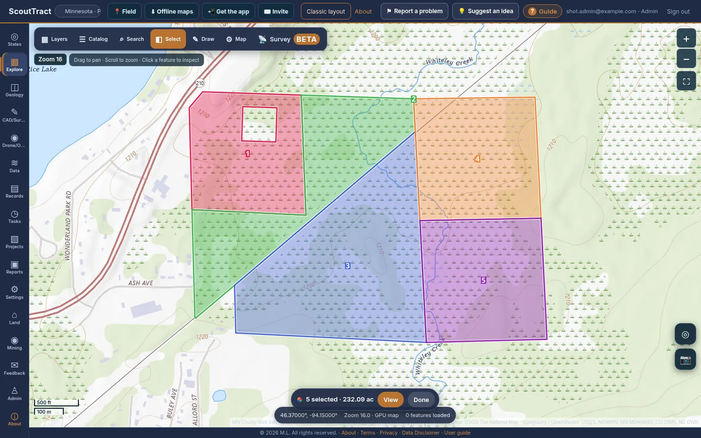
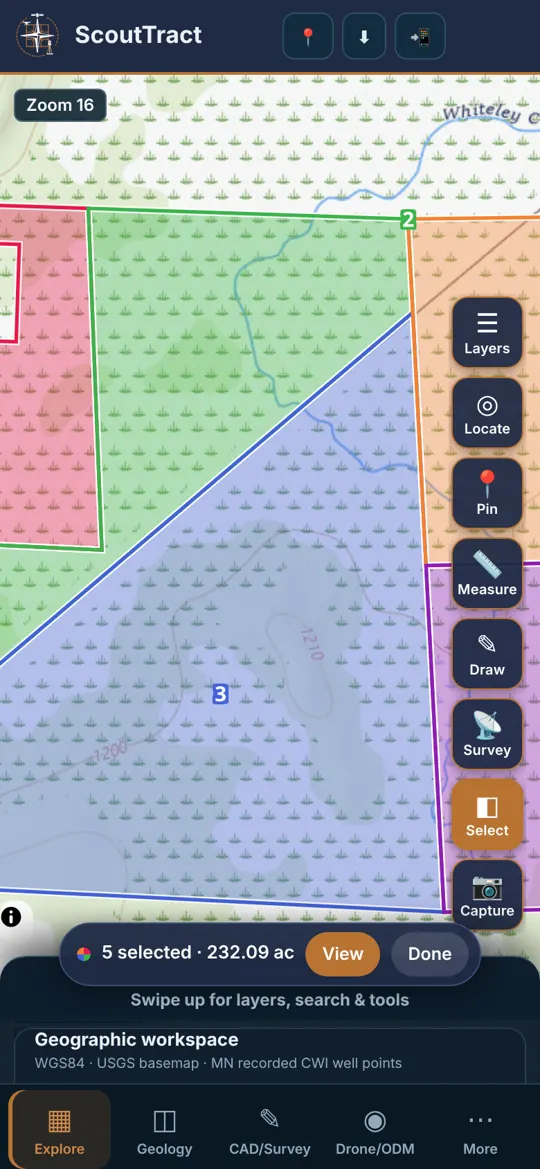
Pick any number of parcels (up to 200), each in its own colour and number, then view or export a cover sheet with parcel IDs, counties, acres, owners, legal descriptions, a map, and any of the optional sections below.
- Turn on Select: the ◧ Select button in the map bar (computer), the Select button in the map control column (phone), or Select parcels on map in the Search window.
- Click or tap parcels. Each one is looked up live, outlined in its own colour and numbered. Click a selected parcel again to remove it. Pan and zoom freely; the selection stays (it is also kept if you reload).
- From owner search results, press + Select on a row or Add all to selection. In a parcel’s information window, press + Add to selection.
- The bar at the bottom of the map shows how many parcels and acres are selected. Press View for the list: colour and number, parcel ID, county and state, acres, owner, legal / PLSS (Texas: abstract and survey), site address. Change a parcel’s colour with its swatch, zoom to one or all, remove one, or Clear all.
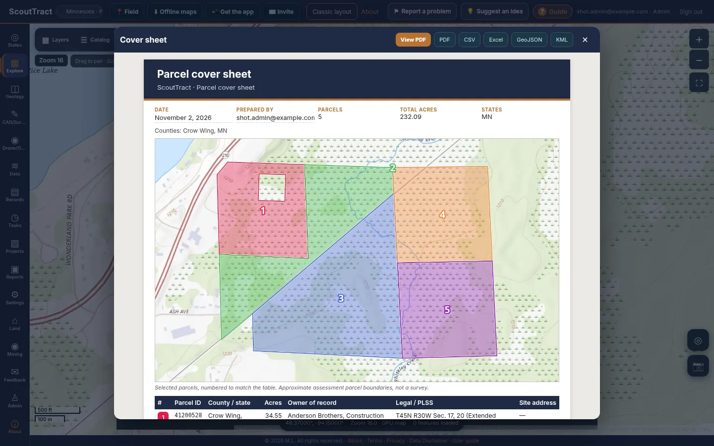
- Press Cover sheet & export. Edit the title, date and prepared-by name, check the map and table, then View PDF or download PDF, CSV, Excel, GeoJSON or KML. On a phone, View PDF opens it in a new tab to read, share or save.
| On the cover sheet | Details |
|---|---|
| Header | ScoutTract navy and copper band, your title, the date and who prepared it (defaults to today and your profile name; both editable) |
| Map | The selected parcels in their colours with matching numbers (drawn from the map you see) |
| Table | Number and colour, parcel ID, county / state, acres, owner of record, PLSS or Texas survey plus the legal description, site address, and a totals row |
| Mailing address | Only for parcels added from owner search |
| Notes and footer | Data sources and date, how acres were measured, and the standard disclaimer footer (when the PDF footer is on) |
Choosing what goes on the cover sheet
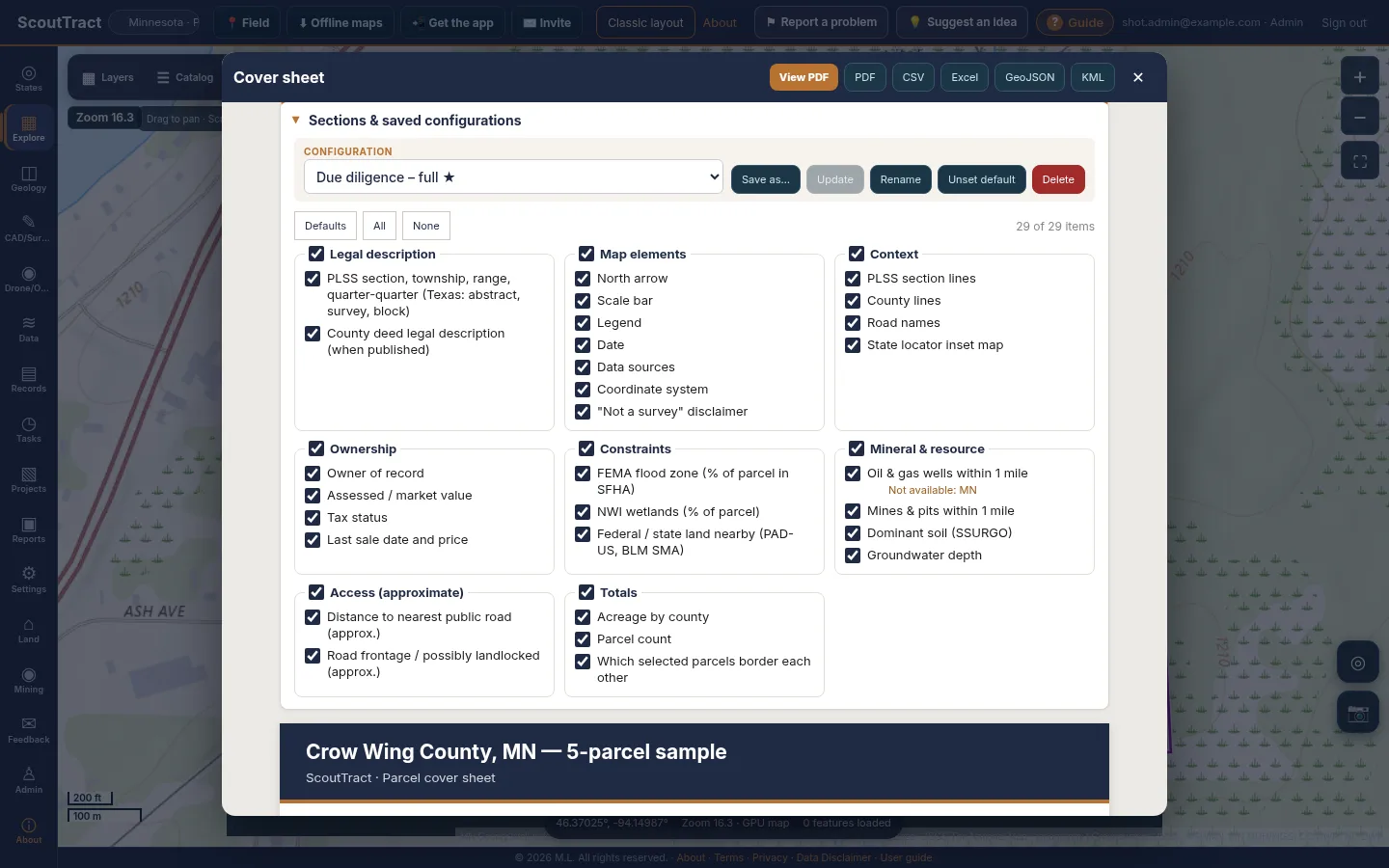
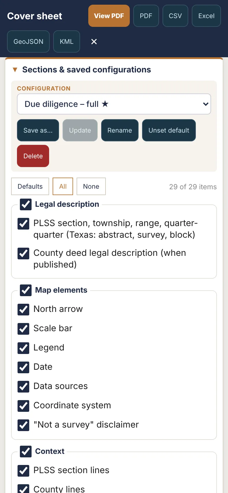
Open Sections & saved configurations at the top of the cover sheet. Every item is a checkbox; a group checkbox turns the whole group on or off. Defaults, All and None are quick resets. What you tick drives the on-screen preview, the PDF, the CSV and Excel columns, and the GeoJSON and KML attributes. Only the ticked items are fetched, live from free public sources, so a short sheet is also a fast one. Your last choice is remembered on this device.
| Group | Items |
|---|---|
| Legal | PLSS township, range, section and quarter-quarter (BLM CadNSDI); Texas abstract, survey and block (GLO / RRC); the county deed legal description |
| Map elements | North arrow, scale bar, legend, date, data sources, coordinate system, “not a survey” disclaimer |
| Context | PLSS section lines, county lines and road names drawn on the map, and a state locator inset |
| Ownership | Owner of record, assessed or market value, tax status, last sale date and price (the mailing address appears only for parcels added from owner search) |
| Constraints | FEMA flood zones, NWI wetlands, federal or state land (PAD-US, BLM) with the percent of each parcel affected |
| Mineral and resource | Oil and gas wells within 1 mile, mines and pits, dominant SSURGO soil, approximate depth to groundwater |
| Access | Distance to the nearest public road and a frontage / possibly landlocked flag (both approximate) |
| Totals | Acres by county, parcel count, and which selected parcels border each other |
Where a state has no free source for an item the sheet says Not available for this state (for example oil and gas wells in Minnesota, Iowa, Nebraska and Arizona, or PLSS lines in Texas). If a source does not answer in time the item says so and the rest of the sheet is still produced.
Saved configurations
Press Save as… to store the ticked items with the current title and prepared-by name under a name such as Due diligence or Mineral review. Pick one from the Configuration list to apply it. Update saves changes into the selected configuration, Rename and Delete do what they say, and Make default marks the one used on any device where you have not chosen yet (your first saved configuration starts as the default; ★ in the list). Configurations are saved to your account (up to 30), so they follow you between computer and phone, and nobody else can see them.
Please note: Exports need the export right for every state in the selection. Acres are the assessor or GIS figure where the county publishes one, otherwise computed from the parcel polygon. Flood, wetland, access and groundwater figures are approximate screening values. The cover sheet is not a survey.
Geology and 3D
Geology layers are in the layer list for each state: for example NDGS bedrock and surface geology in North Dakota, MGS depth to bedrock in Minnesota, Iowa Geological Survey bedrock and karst, and the Geologic Map of Arizona with faults and earth fissures, and the 1:500,000 state geologic maps of Montana, Wyoming, New Mexico and Utah (Nebraska uses the USGS compilation). The federal group adds the USGS State Geologic Map Compilation, faults, gravity and magnetics.
Geology tab
- Open Geology (◫). Pick the state and one or more counties.
- Draw an area with Draw area: 2 corners, or a cross-section line with Draw A–B: 2 points.
- Press Find all well records or Create observed A–B section.
- Export the well records as CSV, a wells + stratigraphy ZIP, or an 11×17 area or A–B section PDF.
3D viewer
- Minnesota: observed well logs in 3D and a regional interpreted model, with GeoTIFF, 3D PDF, HTML and GLB exports.
- North Dakota and Colorado: USGS 3DEP land-surface terrain. This is land elevation only, not underground geology.
- Choose the 3D view in the Geology tab.
- Press Open 3D viewer. Drag to orbit, scroll or pinch to zoom.
Tip: Pick a small area for 3D; big areas take longer to load.
Wells and groundwater
Open Groundwater & water wells in the layer list.
- Depth to water on state well records (Minnesota CWI, Colorado DWR permits, North Dakota imports), coloured by depth.
- Monitoring wells (USGS, NGWMN, MN DNR, CO DWR). Click one for a small water-level chart. A white ring means read in the last 2 years; yellow is older.
- Groundwater surface (estimate): press Surface for view or Draw area to build a water-table or depth-to-water surface with contours and a CSV download.
- Context overlays: USGS principal aquifers and depth to bedrock from Minnesota well logs.
State well layers include Minnesota County Well Index, North Dakota oil & gas wells, Colorado ECMC wellbores and DWR permits, Texas RRC wells, Iowa GeoSam wells, Arizona ADWR wells, Montana GWIC and oil & gas wells, Wyoming WOGCC wells and State Engineer permits, Nebraska DNR registered wells, New Mexico OCD wells and OSE points of diversion, and Utah DOGM wells and water-right points of diversion. The panel tells you to zoom in to N when needed.
Please note: Groundwater values are estimates from public records, not a survey. Old readings are faded.
Mines and DOT pits
Open Mines & DOT sources in the layer list.
- US Historical Mines (USGS MRDS): filter by development status (producer, past producer, prospect, occurrence, plant).
- DOT approved aggregate sources: turn on the states you want. Filled dots use the coordinates the DOT published (or ones derived from PLSS, address or name).
- Material class filters both: Quarry (crushed or dimension stone), Sand & Gravel and Unknown.
- Approximate locations: some DOT lists have no coordinates. These are placed from the listed address or the town or county centre and drawn as hollow rings. Click a ring to see how good the match is.
- All 50 state lists links to every state DOT’s list.
Please note: Approximate locations can be miles off. Always verify a pit or quarry with the DOT or the operator before relying on it.
State layers add more: Iowa quarries and historic coal mines, Arizona active mines and aggregate plants, Minnesota mineral leases, Montana DEQ opencut (gravel) and hard rock sites, Wyoming county pits and limited mining operations, New Mexico MMD registered mines, Utah mineral occurrences and SITLA sand & gravel contracts. Nebraska has no state mine layer (USGS MRDS only).
Flood and hazards
FEMA flood zones
- Turn on Flood hazard zones · FEMA NFHL.
- From zoom 8 the map shades where FEMA digital flood maps exist.
- From zoom 12 you see the flood zone polygons: 1% annual chance (A, AE, AO, AH, V, VE) and 0.2% annual chance.
- Click a parcel for its zone, FIRM panel and effective date.
Hazards & environment
National Risk Index, wildfire hazard and current fires, Quaternary faults, landslide susceptibility, wetlands, abandoned mine lands, and EPA Superfund, RCRA and brownfield sites. Federal reference layers add land ownership, BLM claims and leases, wilderness, critical habitat, pipelines, soils and more. A layer that cannot be reached says unavailable without affecting the others.
Please note: Flood and hazard layers are informational, not an official flood determination. FEMA’s Map Service Center FIRMs are authoritative.
Drawing and measuring
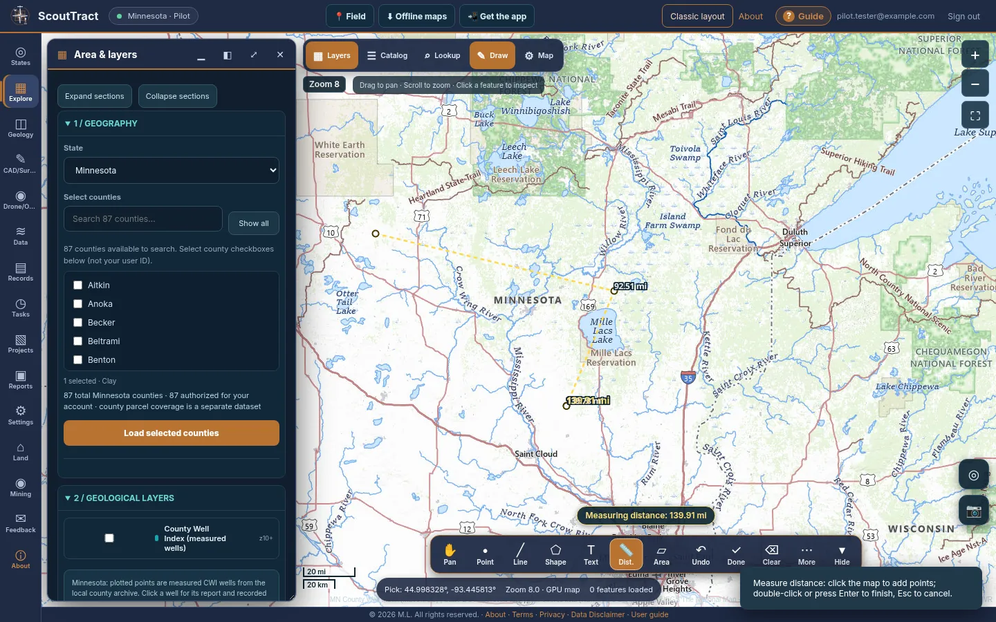
The floating draw toolbar sits on the map, so the map keeps its full size while you work.
Open it
- Map-first layout: press Draw ✎ on the map bar.
- Classic layout: press Draw, measure & label on the map.
- Phone: press Draw in the button column on the map.
The tools
| Button | What it does |
|---|---|
| ✋ Pan | Move the map; stops drawing |
| • Point | Drop a point |
| ╱ Line | Click or tap points, then Done |
| ⬠ Shape | Draw a polygon: click or tap corners, then Done |
| T Text | Place a text label |
| 📏 Dist. | Measure a distance |
| ▱ Area | Measure an area |
| ↶ Undo | Undo the last point or shape |
| ✓ Done | Finish the shape or measurement (or press Enter / double-click) |
| ⌫ Clear | Clear measurements or discard unsaved drawings |
| ⋯ More | Colour, label, project, use selected parcel, save and load |
| ▾ Hide | Shrink the toolbar to a small Draw button |
The chip above the toolbar shows the live length or area and a hint for the next step.
Save to a project
- Press ⋯. Pick a colour and label, and choose a project.
- Press Save drawings to project. Load saved drawings brings them back later.
- Use selected parcel copies the clicked parcel outline as a shape. Close drawing tools closes the toolbar.
Please note: Measurements are geodesic, not survey grade.
Projects
- Open Projects (▧). Enter a project name, state, county and a short description, then Create project.
- Import files into the project: CSV, KML, KMZ, DXF or GeoJSON. Pick the coordinate system if it is not latitude/longitude.
- Save drawings and parcel boundaries to the project from the map.
- In CAD/Survey (✎) open a project drawing, edit it, save a new DXF revision or download the DXF.
Your projects are private to your account.
Reports and PDF
- Open Reports (▣) and pick a project.
- Click a spot on the map and press Use selected map location, or type a latitude and longitude.
- Give the report a title and press Generate PDF + ZIP.
- A progress list shows each step. When it is done, download the 11×17 PDF and the ZIP, or share the PDF from your phone.
Depending on the place, the report includes GLO plats and field notes, FEMA flood zones, property tax and assessment, hazards & environment screening, state data layers, and mines & DOT material sources.
Other exports: geology area and A–B section PDFs, well CSV and ZIP files, and the Records download cart.
Using it on your phone
ScoutTract offers an Android app download (APK) and install instructions. Download the APK, then open it to install; Google Play is coming soon. You can also use your phone’s browser and add the web app to your home screen from the browser menu.
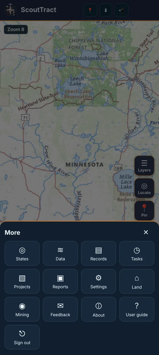
- The map fills the screen. Tabs are along the bottom: Explore, Geology, CAD and Drone, plus More (⋯) for everything else, including this User guide and Sign out.
- The button column on the right holds Layers, Locate (your GPS position), Pin, Measure, Draw and Capture.
- Drop a pin with the Pin button or a long-press on the map. The pin card shows coordinates and the PLSS section, with Save point, Copy and Directions.
- Panels open as a bottom sheet. Drag it up for more, or down to see the map.
- The zoom badge sits on the map, just like on a computer.
Survey (Beta): collect, stake out, COGO
Survey connects ScoutTract to an RTK GNSS receiver so you can collect points, stake out points and lines, run COGO and move files to and from Emlid Flow or Trimble Access. It is in Beta: check into a known control point before relying on results.
- Open 📡 Survey: on a computer it is in the map toolbar; on a phone it is in the button column on the right.
- Project tab: create a project with a State Plane zone (NAD83(2011)) or UTM/WGS84, and units (US survey feet, international feet or metres). Projects and points are private to your account.
- Connect tab: choose your receiver (see the Emlid and Trimble sections below), set the pole height, then press Start. The status bar shows fix, accuracy, satellites and PDOP.
- Collect: wait for RTK fixed and an accuracy at or under the warning limit (5 cm by default), enter point, code and description, then Measure. Positions are averaged over the epochs you set.
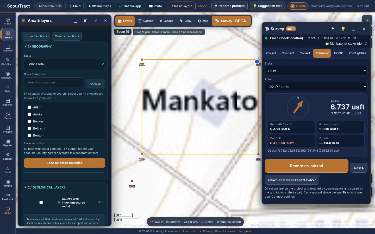
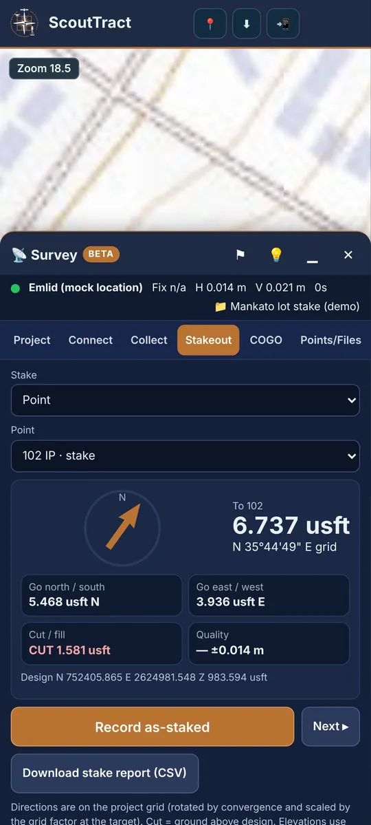
- Stakeout: pick a point, a station and offset along a line, or a line vertex. Follow the arrow and the go-north/go-east distances; cut/fill appears when the target has an elevation. Record as-staked stores the point and its deltas; download the stake report from the same tab.
- COGO: inverse, forward, traverse with closure, bearing–bearing, distance–distance and bearing–distance intersections, station/offset and area. Tick Store result points to save them.
- Points/Files: import CSV (PNEZD, PENZD or your own column mapping), DXF, a zipped shapefile, GeoJSON, KML/KMZ or Trimble JobXML as stake targets. Export CSV (Emlid or Trimble layouts), DXF, shapefile, KML or JobXML.
Tip: A shapefile becomes a DXF for your data collector in two steps: import the .zip here (it is reprojected from its .prj), then export DXF. Set the same coordinate system in Emlid Flow or Trimble Access before importing the file there.
Please note: Elevations: Android mock location reports height above the ellipsoid. {app} subtracts the GEOID18 separation from the NGS Geoid API to give NAVD88 elevations. Antenna height: Trimble Mobile Manager already applies it; with Emlid mock location {app} subtracts the pole height you enter. Confirm both on a benchmark on your first day.
Use ⚑ or 💡 in the Survey header to report a problem or suggest an improvement.
Survey: connecting an Emlid Reach
Emlid Flow does not share positions with other apps directly. Android’s mock location, provided by the free Lefebure NTRIP Client, passes the Reach position to the phone’s location so ScoutTract can read it.
- Install Lefebure NTRIP Client from Google Play.
- Turn on Developer options (Settings → About phone → Software information → tap Build number 7 times). In Developer options choose Select mock location app → Lefebure NTRIP Client.
- In Lefebure → Settings → Receiver Settings: Receiver Connection = External via Bluetooth, pick your Reach, Bluetooth Connection Method = Secure via Reflection, turn on Enable GPS Mock Locations.
- In Emlid Flow turn on Bluetooth Discoverability, pair the Reach in Android Bluetooth settings, and set Position streaming 1 to Bluetooth, NMEA.
- Corrections: on the receiver (Emlid Flow → Correction input: NTRIP over its own SIM/Wi-Fi, or LoRa) or, for Reach RX, through Lefebure’s NTRIP settings. Tap Connect.
- In {app} Survey → Connect choose Emlid (mock location), pick your Receiver model ({app} adds its NGS antenna phase-centre offset), enter the pole height to the bottom of the receiver, and press Start. RS3/RS4 with tilt: set the height in Emlid Flow only and tick Tilt compensation on.
Mock location does not carry the fix type: confirm FIX in Lefebure or Emlid Flow once per session when ScoutTract asks. Use Collect → Check in on known point before real work. Source: Emlid docs: Mock location.
Survey: connecting a Trimble receiver
Trimble Mobile Manager (TMM) connects Trimble receivers (R12i, R10, R8s, R2, R580, R780, Catalyst DA2) and shares the position through Android mock location.
- In TMM connect the receiver and set the corrections source.
- TMM → Application settings → Share location → SETUP opens Developer options: Select mock location app → Trimble Mobile Manager.
- Back in TMM turn on Share positions. Turn off battery optimisation for TMM.
- Leave TMM’s Apply antenna height off. In {app} Survey → Connect choose Trimble (mock location), pick your receiver model, enter the pole height to the bottom of the receiver (TMM reports positions there) and press Start.
Trimble TMM WebSocket (experimental) reads TMM’s local data stream on the same phone. It adds the RTK fix type, receiver model, RMS accuracy and Catalyst subscription level.
Tip: Catalyst DA2 accuracy depends on the subscription: Catalyst 60, 30 and 10 are sub-metre to decimetre; only Catalyst 1 (1–2 cm) meets the 5 cm warning.
Sources: Trimble Mobile Manager help (Location sharing) and the Trimble developer documentation for TMM.
Survey: OPUS (NGS static processing)
OPUS, the National Geodetic Survey’s Online Positioning User Service, processes a static GNSS file against the CORS network and emails a NAD83(2011) solution. NGS takes files only through its own web page, so ScoutTract prepares the submission and reads the result back.
- Log a static occupation: at least 15 minutes for OPUS Rapid-Static, or 2 to 48 hours for OPUS-Static. Export the RINEX observation file from Emlid Studio or Trimble (Convert to RINEX).
- Survey → OPUS: choose the file, the antenna (NGS code), the vertical height to the antenna reference point in metres, and your email. Press Check file; {app} checks duration, interval, GPS data and the antenna code.
- Press Open NGS OPUS upload and enter the values shown (each has a Copy button) on the NGS page.
- When the OPUS email arrives, paste the report into step 2 and press Read report. {app} flags weak solutions (low observations used, low fixed ambiguities, high RMS) and can save the position as a control point.
Submissions and results are listed under History. Source: NGS OPUS.
User guides (PDF downloads)
Longer step-by-step guides live under User Guides. Each comes in a Mobile edition (phone screenshots, a narrow PDF to read on a phone) and a Desktop edition (computer screenshots, a letter-size PDF to print). The page opens the edition for your device; switch with the Mobile / Desktop buttons at the top.
- ScoutTract user guide (all features): every section of the app with screenshots, from signing in and installing to parcels, multi-parcel select, hazards, reports, invites, settings, feedback and administration. Mobile edition (PDF) · Desktop edition (PDF).
- GPS field guide: Survey (Beta): Emlid Reach and Trimble setup, RTK fix and antenna height, collecting, stakeout, COGO, exports, OPUS, troubleshooting and checklists. Mobile edition (PDF) · Desktop edition (PDF).
Tip: In the installed app, open a guide and press Save for offline to keep it on the phone for sites with no signal.
Changing your password
- Open Settings (⚙).
- In Password & sign-in, enter your current password and a new one of 12 or more characters, twice.
- Press Change password. You stay signed in here; other devices are signed out.
Forgot your password? On the sign-in page press Forgot password?, enter the email or username you sign in with and press Email me a code. Enter the 6-digit code from the email (it expires in 15 minutes) and a new password of 12 or more characters, twice, then press Set new password. No email? Check spam, use Send a new code, or write to catchall@scouttract.com.
Reporting a problem and suggestions
Your feedback shapes the pilot. Two ways to reach us:
- In the app, open Feedback (✉), pick Problem / bug or Idea / improvement, add a title and details, and press Submit ticket. You can see your tickets under My submitted tickets.
- Email catchall@scouttract.com.
Helpful details: the state and place, what you did, what you expected and what happened. A screenshot helps a lot.
Disclaimer
ScoutTract is a research tool. It gathers public data from government and other sources, which can be incomplete, out of date or wrong. Nothing in ScoutTract is a survey, title opinion, legal advice or an official flood, hazard or permit determination. Measurements are approximate. Verify everything with the official source and on the ground before you rely on it. See the Terms of Service, Privacy Policy and Data Disclaimer.