User Guides › ScoutTract user guide (all features)
ScoutTract user guide (all features)
Computer screenshots, click steps, windows, the left rail and keyboard shortcuts.
Contents
- What ScoutTract does
- Getting in: sign in, request access, your trial
- Install ScoutTract on your phone
- Finding your way around
- Choosing a state
- Automatic county records
- Map layers and the data catalog
- Layer library and groups
- Parcel search: address, parcel ID, owner
- Legal descriptions: PLSS sections and Texas surveys
- Parcel information: owner, GLO, FEMA, tax and zoning
- Selecting several parcels and the cover sheet
- Drawing and measuring
- Flood, hazards and federal land
- Wells and groundwater
- Drill data (Beta)
- Mines and DOT gravel pits
- Field capture and offline maps
- Geology, cross sections and 3D
- Reports, printing and PDFs
- Projects and CAD/Survey drafting
- Records, downloads and agency data
- Background exports, My downloads and export destinations
- Land, mining compliance and tasks
- Drone/ODM
- GPR and ERT add-ons (under construction)
- Survey (Beta) with an RTK receiver
- Inviting someone to a free trial
- Settings, password and account
- Safety: SOS, emergency contacts and medical info
- Signed-in devices and new-device alerts
- Feedback: report a problem or suggest an idea
- Administration (administrators only)
- Known limits during the pilot
- Terms, privacy and data disclaimer
1 · What ScoutTract does
ScoutTract is a map for land, mineral and geology research across twelve states. On one map you can:
- find a parcel by address, parcel ID or coordinates, or every parcel an owner holds in a state;
- read the parcel’s owner, acreage, legal description, flood zone, tax figures, hazards and nearby mines;
- select several parcels and print a cover sheet with a map and table;
- turn on public layers: geology, wells and groundwater, mines and DOT gravel pits, FEMA flood zones, hazards and federal land;
- draw and measure, build projects, make 11×17 research reports, and look at geology in 3D;
- capture field notes and photos, save maps for offline use and, in Beta, survey with an RTK receiver.
This is the Desktop edition. It shows ScoutTract on a computer: the map bar, floating windows, the left rail and keyboard shortcuts. On a phone? Read the Mobile edition.
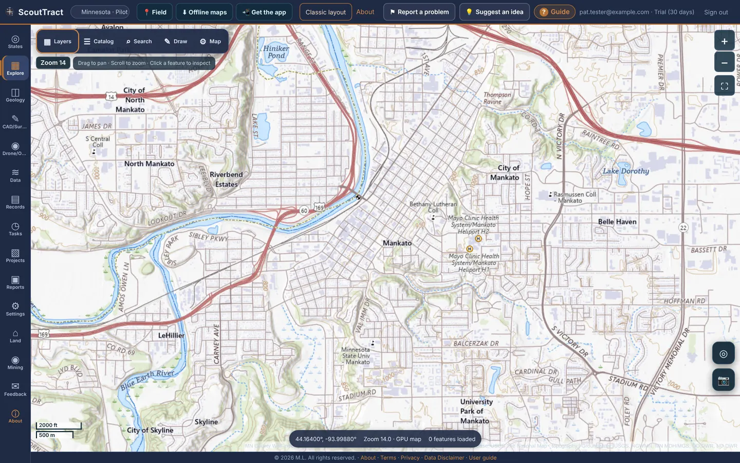
The eleven pilot states: North Dakota, Minnesota, Colorado, Texas, Iowa, Arizona, Montana, Wyoming, Nebraska, New Mexico, Utah and North Carolina. Each state has its own public data, so the layers differ from state to state.
Research only. ScoutTract gathers public government data, which can be incomplete, out of date or wrong. Nothing in it is a survey, a title opinion or an official flood or permit determination. Check the official source before you rely on anything.
2 · Getting in: sign in, request access, your trial
Sign in
- Open scouttract.com.
- Enter your Email and Password and click Sign in.
- ScoutTract opens the map at the state you used last.
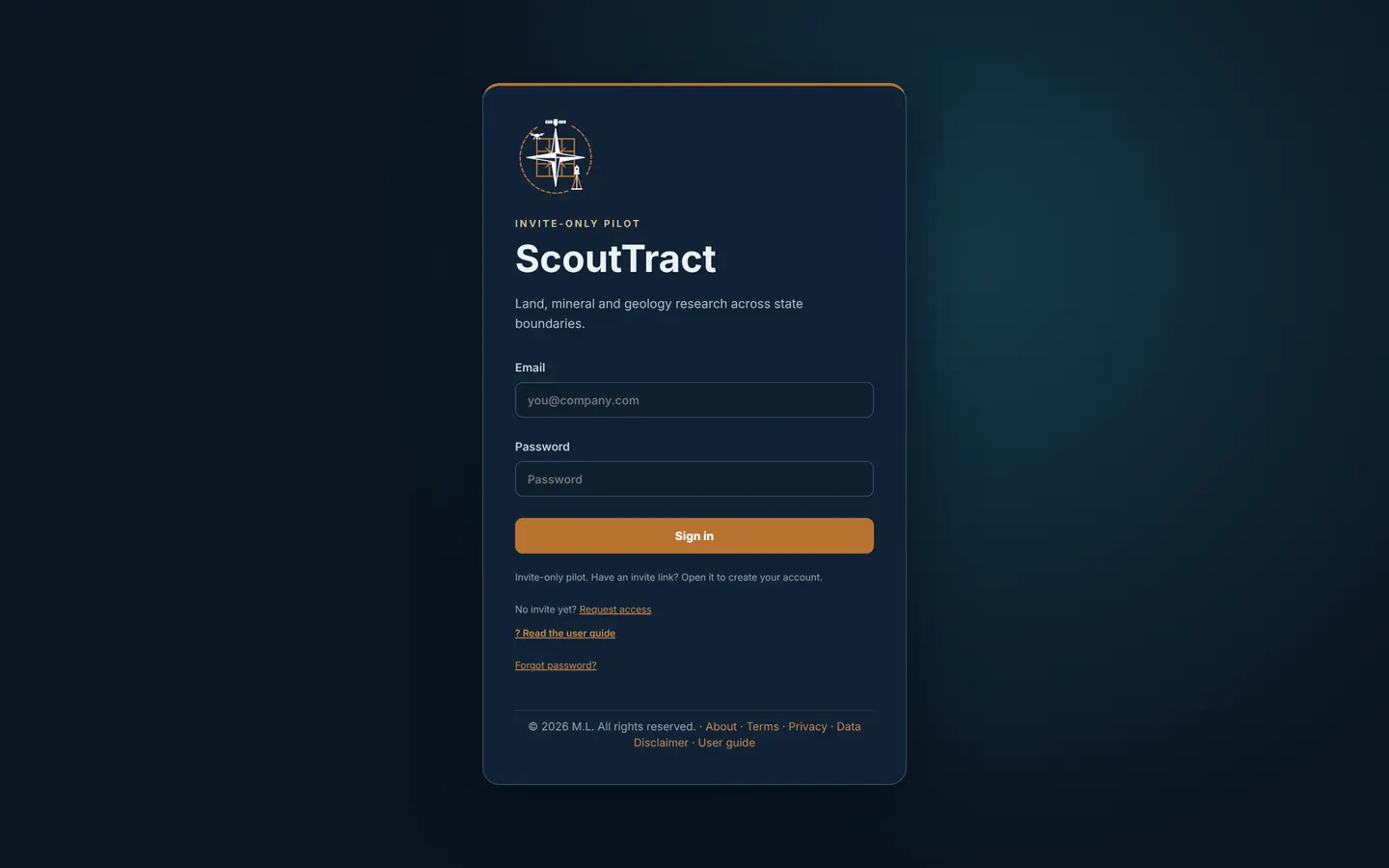
No account yet? Request access
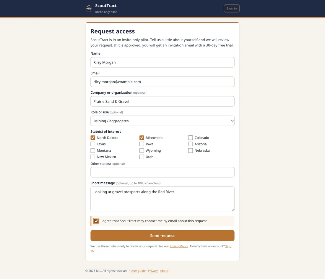
ScoutTract is an invite-only pilot. Click Request access under the sign-in form.
- Enter your Name and Email. Company or organization, Role or use, Other state(s) and a Short message (up to 1000 characters) are optional.
- Tick the State(s) of interest.
- Tick I agree that ScoutTract may contact me by email about this request, then click Send request.
- The ScoutTract team reviews it. If it is approved, you get an invitation email with a 30-day free trial.
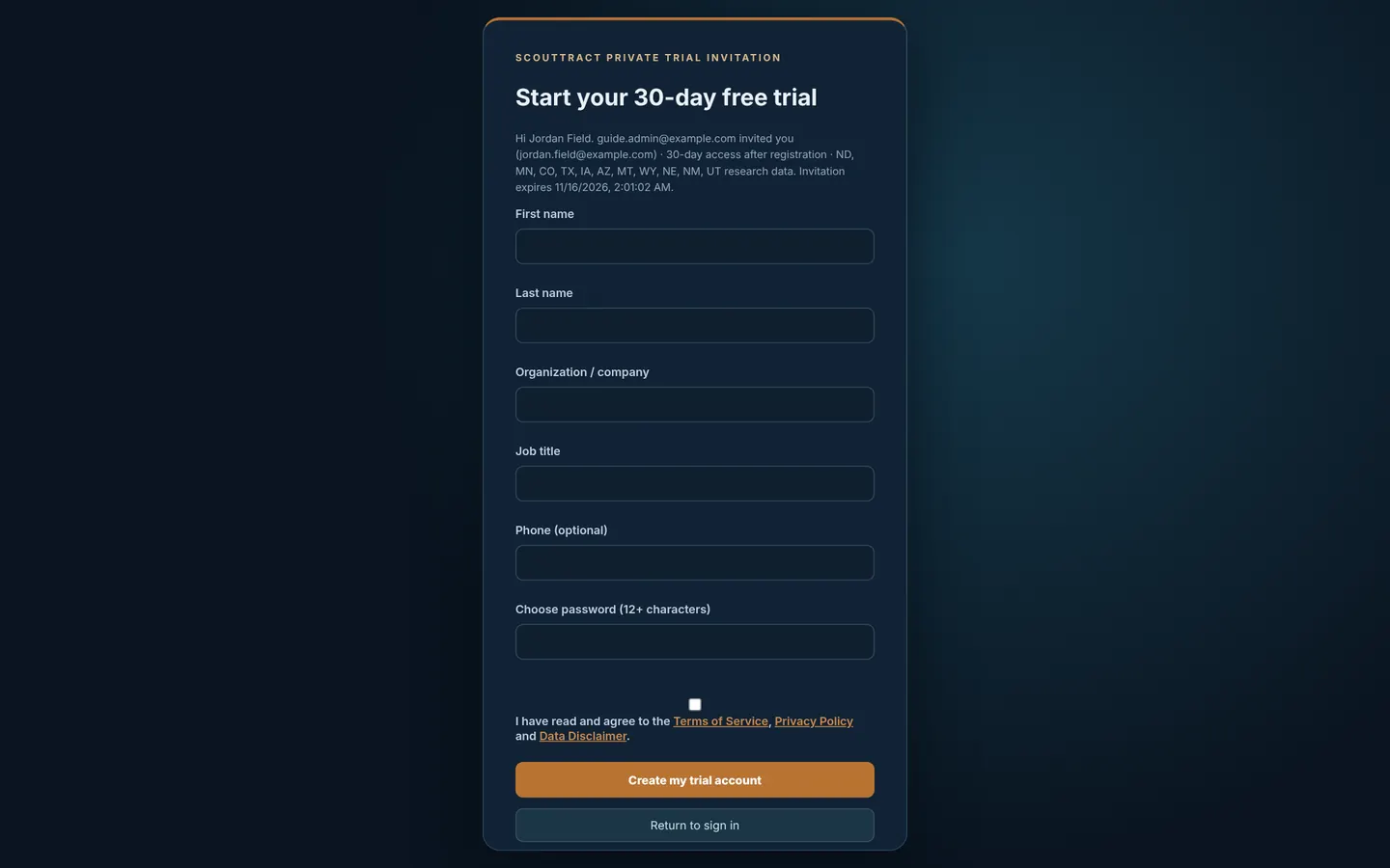
Accept your invitation (the 30-day free trial)
- Open the private link in your invitation email or text. It works once and expires after 14 days.
- The page says who invited you, which states you get, and when the link expires. Fill in First name and Last name. Organization, Job title and Phone are optional.
- Choose a password of 12 or more characters.
- Tick I have read and agree to the Terms of Service, Privacy Policy and Data Disclaimer, then click Create my trial account. You are signed in straight away.
The trial lasts 30 days from the day you accept. No payment details are needed. A banner shows the days left (Free trial: 30 days left) with a tick box, Email me before it ends. Your access never goes beyond the inviter’s own state permissions. If the terms are updated later, ScoutTract asks you to accept the new version once.
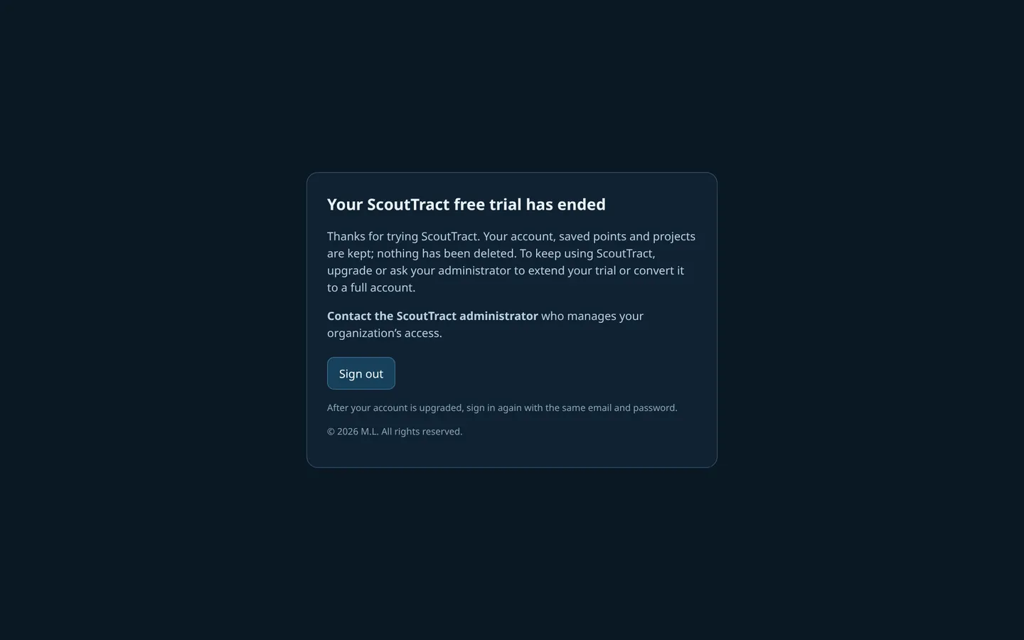
When the trial ends, you see Your ScoutTract free trial has ended. Your account, saved points and projects are kept. Ask the administrator who manages your access to extend the trial or convert it to a full account, then sign in again with the same email and password.
Forgot your password
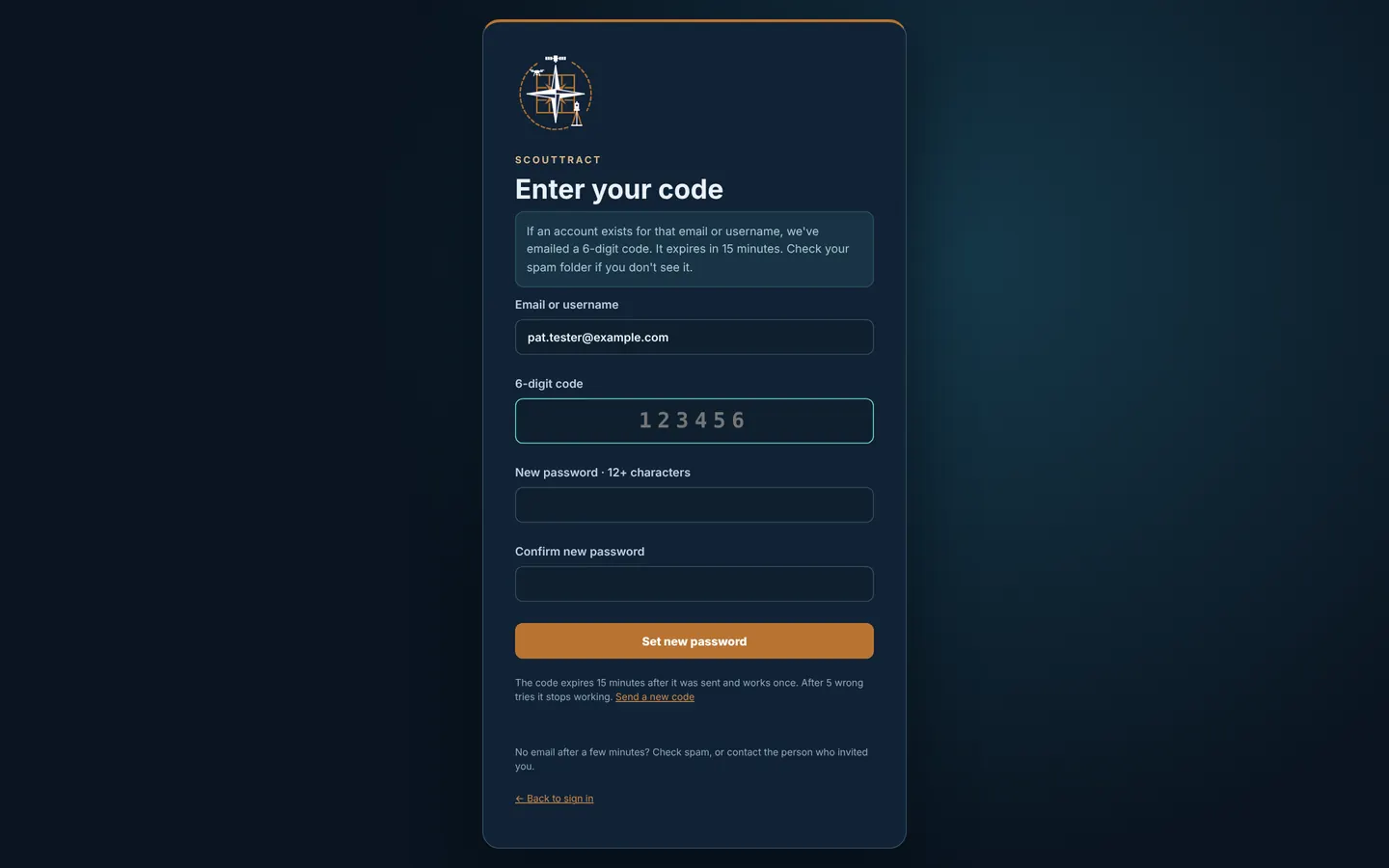
- Click Forgot password? on the sign-in page.
- Enter the email or username you sign in with and click Email me a code.
- Check your email for a 6-digit code; it expires in 15 minutes. Check spam if you don’t see it.
- Enter the code and a new password of 12 or more characters, twice, then click Set new password.
The code works once and stops working after 5 wrong tries; use Send a new code for another. If you already have a code, use I already have a code.
3 · Install ScoutTract on your phone
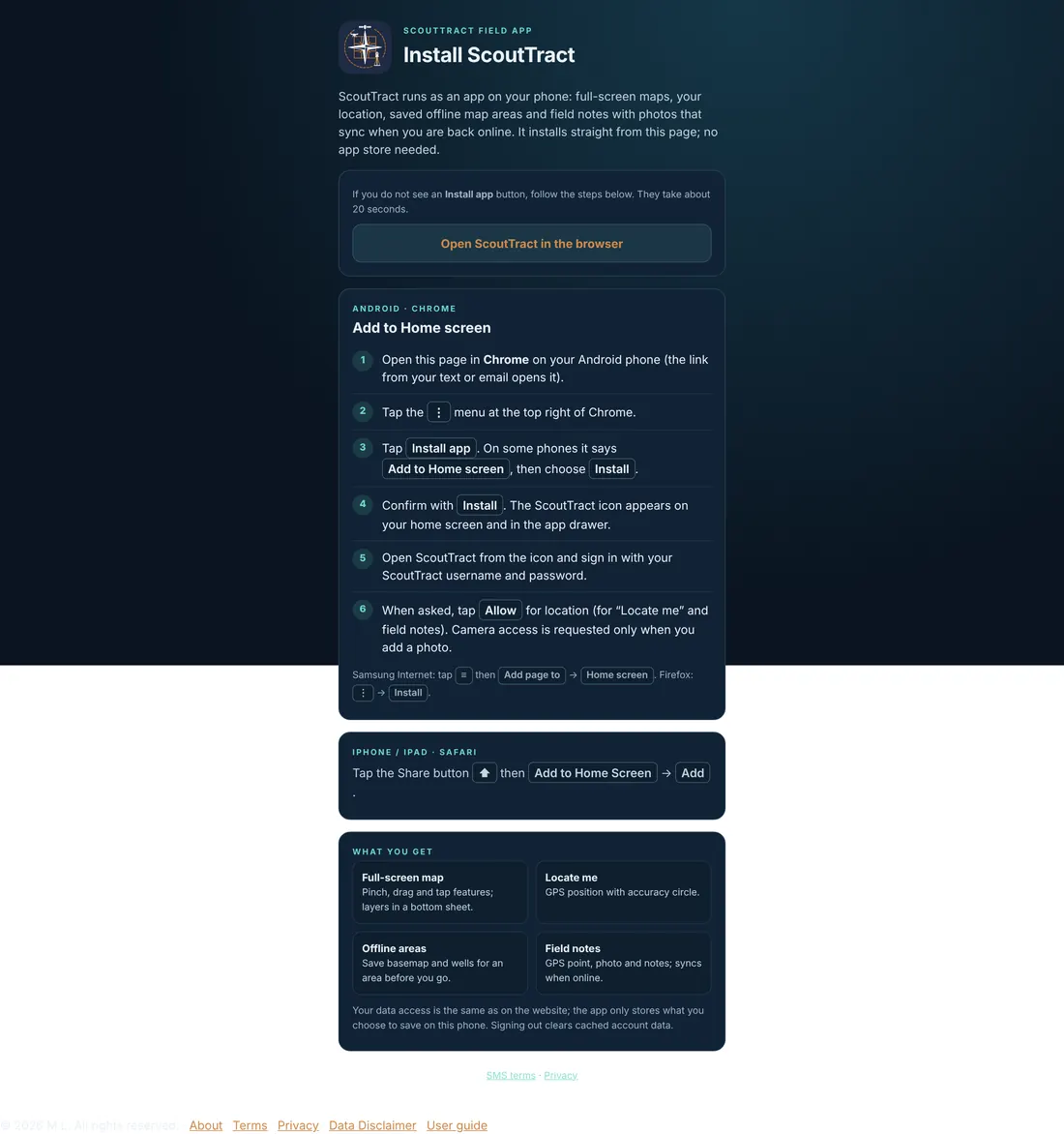
ScoutTract is a web app you install from the browser. No app store is needed. Once installed it opens full screen from its own icon, shows your location, keeps offline maps and syncs field notes when you are back online.
Android (Chrome)
- Open scouttract.com/install in Chrome. If the page shows an Install app button, click it and confirm.
- Otherwise click the ⋮ menu at the top right of Chrome, then Install app (on some phones Add to Home screen, then Install).
- Confirm with Install. The ScoutTract icon appears on your home screen and in the app drawer.
- Open ScoutTract from the icon and sign in.
- When asked, click Allow for location (needed for Locate me and field notes). Camera access is asked for only when you add a photo.
Samsung Internet: ≡ menu → Add page to → Home screen. Firefox: ⋮ → Install.
iPhone or iPad (Safari)
- Open scouttract.com/install in Safari.
- Tap the Share button, then Add to Home Screen, then Add.
Send the app link to a phone
On a computer, click 📲 Get the app in the top bar.
- Copy link copies the install address; Open install page opens it.
- Under Send the link choose Email (or Text message where texting is set up) and click Send link. A text needs the person’s agreement: tick This person asked me to text them the ScoutTract install link. You can send 5 links a day.
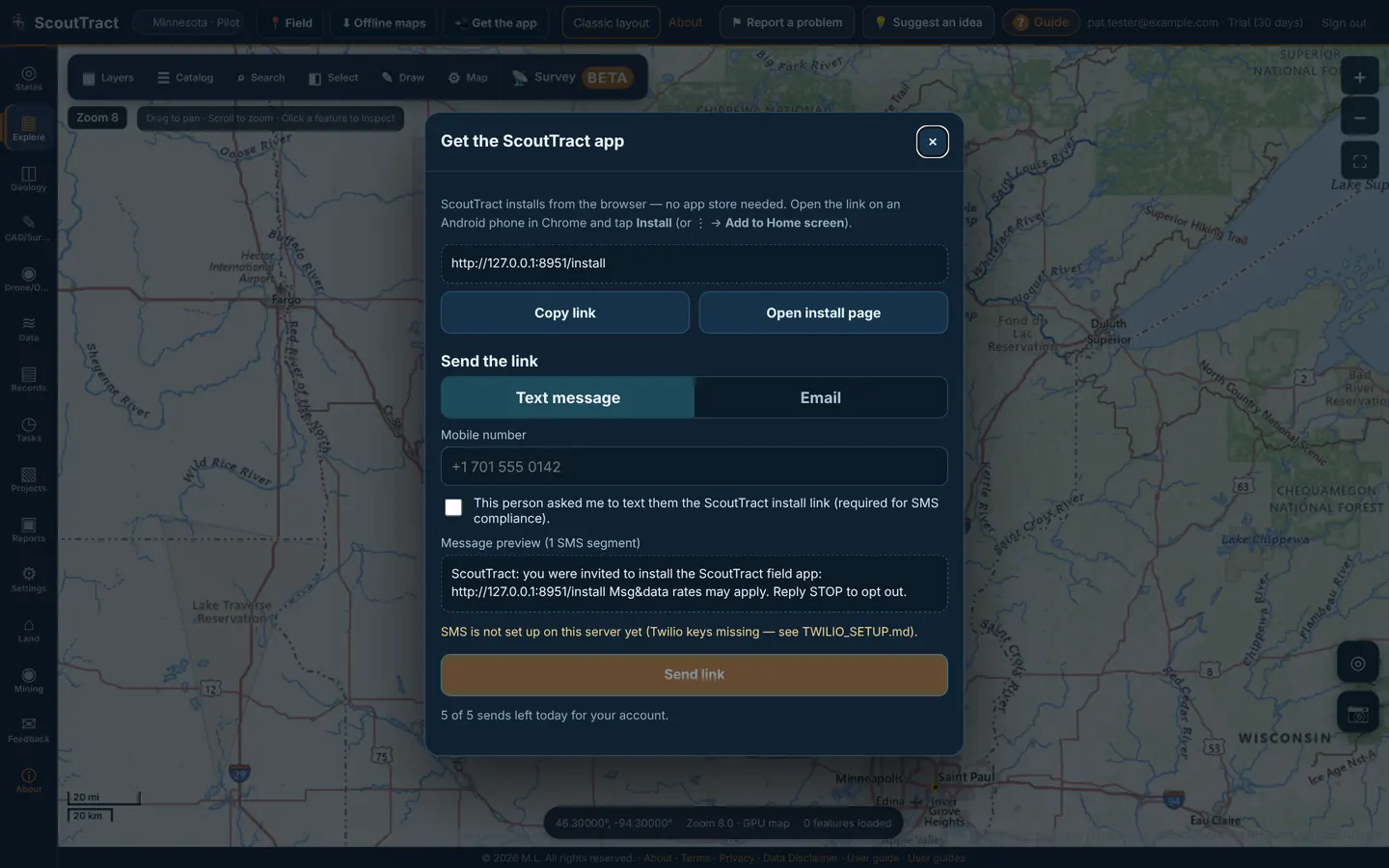
Text messages are not switched on during the pilot (the dialog says SMS is not set up on this server yet). Use Email or Copy link.
4 · Finding your way around
The control column
| Button | What it does |
|---|---|
| Layers | Opens the sheet at the layer list |
| Locate | Shows your GPS position as a blue dot with an accuracy circle (and a heading cone if the phone has a compass). The label reads Located, or Following while the map keeps you centred |
| Pin | Drops a pin in the middle of the map. A long-press on the map drops one where your finger is |
| Measure | Starts measuring with the draw toolbar (see Drawing and measuring) |
| Draw | Opens the draw toolbar |
| Survey | Opens Survey (Beta) |
| Select | Turns on multi-parcel select |
| Capture | Field capture: a photo and a note at your position |
The pin card shows Dropped pin, the latitude and longitude, and the PLSS section (PLSS: Sec 12, T139N, R80W) once it has been looked up. Save point asks for a name and saves it to your account (Records → Saved research locations) when it is inside your selected counties; otherwise it is kept on this device only. Copy copies the coordinates and Directions opens Google Maps directions.
The desktop screen (map-first layout)
- Top bar: 📍 Field, ⬇︎ Offline maps, 📲 Get the app, Classic layout, About, ⚑ Report a problem, 💡 Suggest an idea, ? Guide, your email and plan, and Sign out.
- Left rail: States, Explore, Geology, CAD/Survey, Drone/ODM, Data, Records, Tasks, Projects, Reports, Settings, Land, Mining, Invite, Feedback, About and, for administrators, Admin.
- Map bar (top left of the map): ▦ Layers (area & layers), ☰ Catalog (data catalog), ⌕ Search (parcel search), ◧ Select, ✎ Draw, ⚙ Map (map tools) and 📡 Survey (Beta).
- The map fills the window. Drag to pan, scroll to zoom, right-drag (or Ctrl+drag) to rotate and tilt. The Zoom badge and scale bar sit on the map.
Floating windows
Each map bar button opens a window over the map. By default Area & layers is docked on the left and Map tools on the right; Catalog and Search float. ScoutTract remembers where you put each window.
| Control | What it does |
|---|---|
| Drag the title bar | Move the window |
| Drag the bottom-right corner | Resize it |
| ▁ | Collapse to the title bar (double-click the title to maximise) |
| ◧ | Dock left, dock right or float |
| ⤢ | Maximise or restore |
| ✕ or Esc | Close (Esc closes the top window) |
Keyboard: click a window’s title (or Tab to it), then use the arrow keys to move it 16 px (hold Alt for 1 px) and Shift + arrows to resize it.
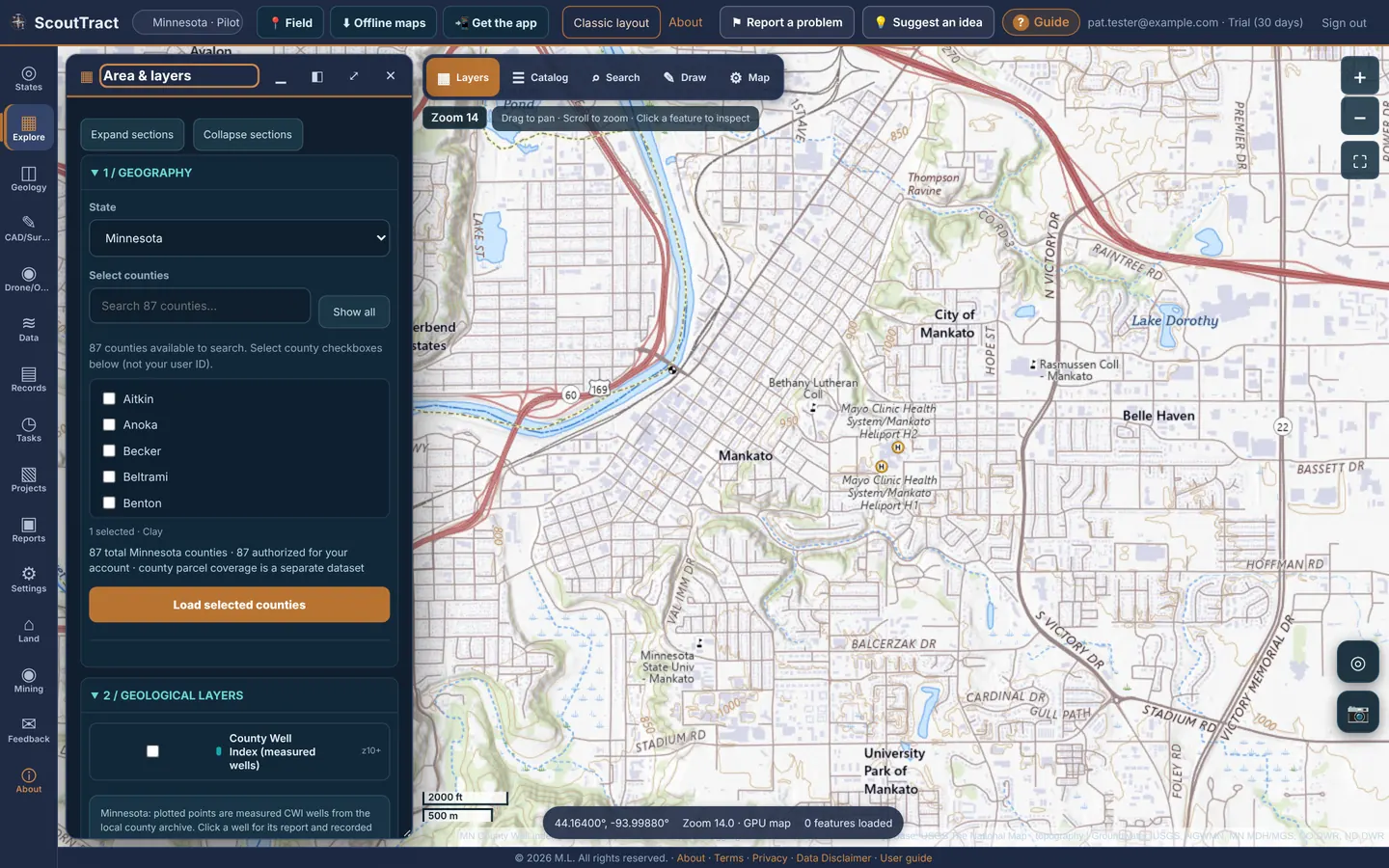
Classic layout in the top bar switches to the older side-panel view with all the Explore cards in one column; Map-first layout switches back. Settings → Viewer mode sets which one opens.
5 · Choosing a state
- Click States in the left rail.
- Click Open <state> on a state card. You only see data for the states your account covers; a card on its own does not grant access.
- The map flies to the state and the layer list switches to that state’s data. ScoutTract remembers the state for next time.
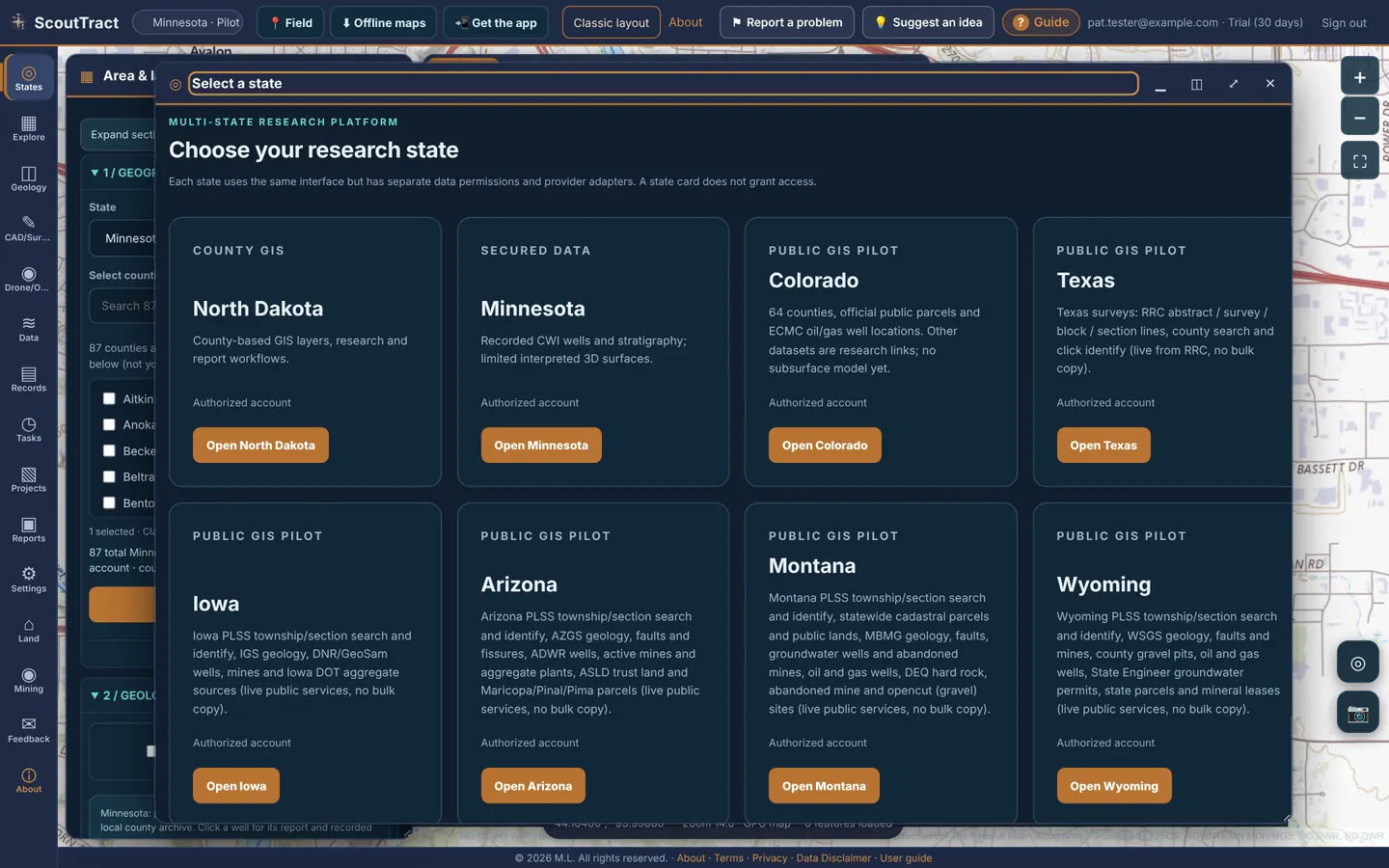
| State | What is there (from the state card) |
|---|---|
| North Dakota | County GIS layers, research and report workflows |
| Minnesota | Recorded County Well Index (CWI) wells and stratigraphy; limited interpreted 3D surfaces |
| Colorado | 64 counties, official public parcels and ECMC oil and gas well locations |
| Texas | RRC abstract, survey, block and section lines, county search and click identify |
| Iowa | PLSS search, IGS geology, DNR/GeoSam wells, mines and Iowa DOT aggregate sources |
| Arizona | PLSS search, AZGS geology, faults and fissures, ADWR wells, active mines and aggregate plants, State Trust land, Maricopa/Pinal/Pima parcels |
| Montana | PLSS search, statewide cadastral parcels and public lands, MBMG geology, faults, groundwater wells and abandoned mines, oil and gas wells, DEQ hard rock, abandoned mine and opencut (gravel) sites |
| Wyoming | PLSS search, WSGS geology, faults and mines, county gravel pits, oil and gas wells, State Engineer permits, state parcels and mineral leases |
| Nebraska | PLSS search, statewide parcels, NeDNR registered wells, depth to groundwater, Ogallala extent, USGS bedrock geology |
| New Mexico | PLSS search, NMBGMR geology, faults and mining districts, OCD wells, MMD mines, OSE wells and county parcels, State Land Office leases and land grants |
| Utah | PLSS search, statewide parcels, UGS geology, faults, mineral occurrences and mining districts, DOGM wells, water-right wells, SITLA trust lands |
Most state data is read live from the public agency service, so a layer can be slow or briefly unavailable when that service is.
6 · Automatic county records
When you zoom in to county scale (zoom 10 or closer), ScoutTract works out which county is under the centre of the map and makes that county's records active for you: parcels, owner, tax and value data and the county layers. You don't have to pick the state and county by hand first.
A small indicator on the map shows which county is active, for example Records: Hennepin County, MN. On a computer it sits just above the coordinates bar at the bottom of the map.
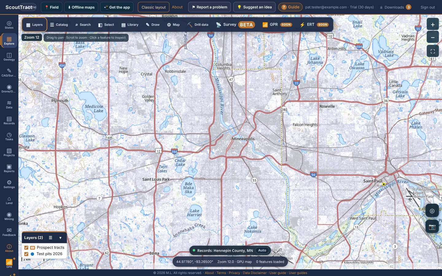
| The indicator shows | What it means |
|---|---|
| Green dot: Records: County, ST | The county is active, with parcels and owner records. |
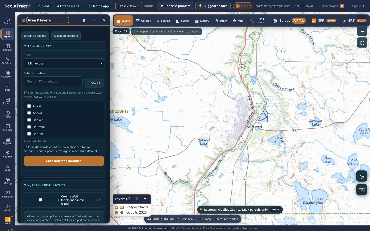
| Amber dot: … · parcels only | The county is active, but it does not publish owner names in free public data. Parcels and county layers still load. |
| Grey dot: … · no record source / not in your account / outside ScoutTract states | Nothing to load for this county. ScoutTract tells you why instead of showing an error. |
| Copper dot and 🔒 Locked | You locked your own county choice, so the map no longer switches counties for you. |

Moving into another county
Pan into the next county and, once the map has stopped moving for about a second, the indicator and active county switch over. If you cross into a neighbouring ScoutTract state that your account includes, the state switches too, and the map stays where you are. Zoomed out past county scale, the indicator hides and nothing changes.
The county ScoutTract picked shows as the selected county in Area & layers → Select counties (for example 1 selected · Nicollet).
Choosing counties yourself (lock)
- Click Auto on the indicator. It changes to 🔒 Locked and the counties you have stay put while you pan.
- Ticking or unticking a county yourself in Select counties locks it automatically, so your choice is never overwritten.
- Click 🔒 Locked to go back to automatic.

County boundaries come from the free U.S. Census TIGERweb service and are remembered, so moving around the same area is instant. Lock or unlock is remembered on this device.
7 · Map layers and the data catalog
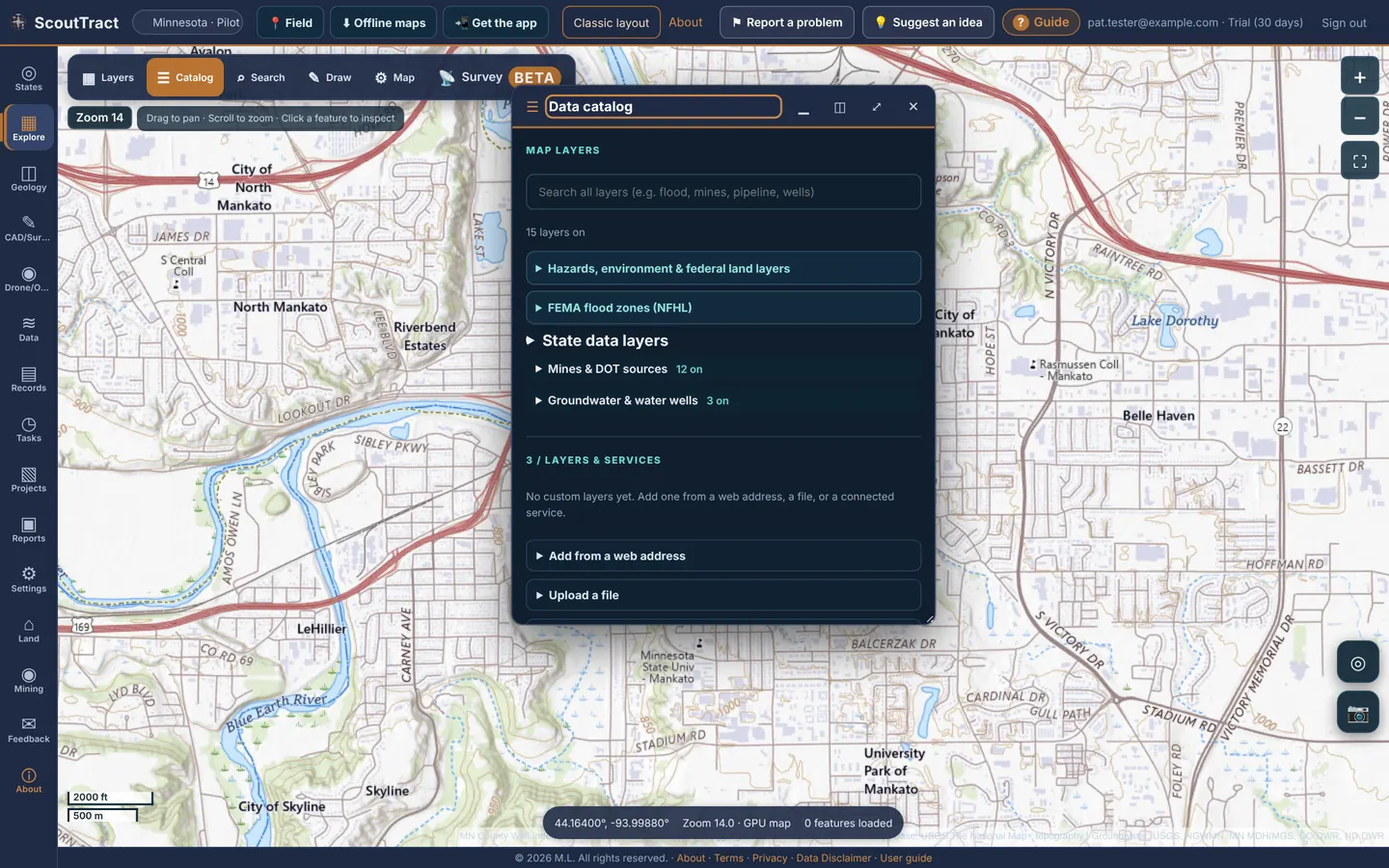
Turn layers on
- Click ☰ Catalog on the map bar.
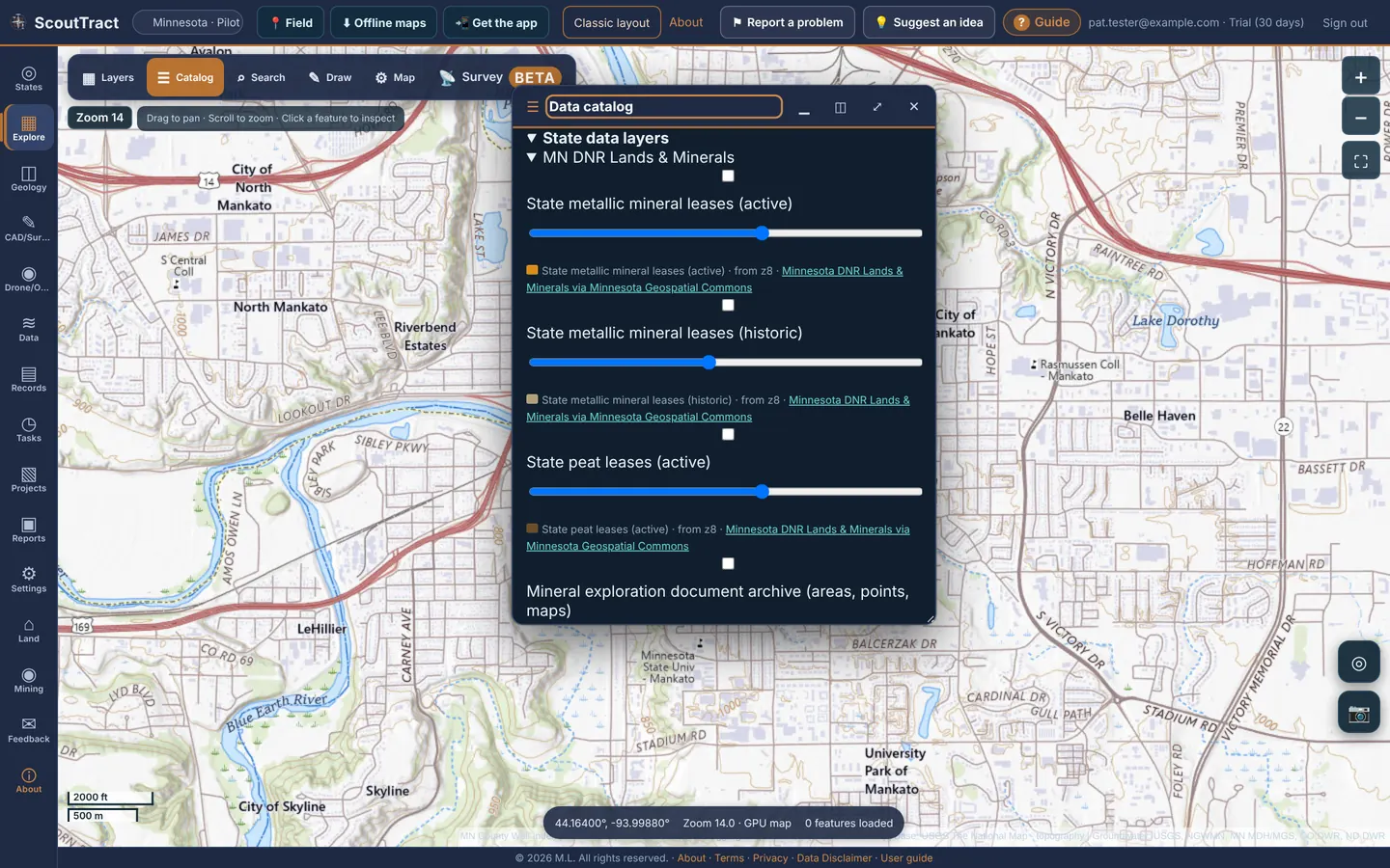
- Type in the search box to filter every group at once, or open a group.
- Tick a layer to turn it on. Many have an opacity slider and a legend.
- Click a feature on the map for its details and a link to the official source.
Groups in Map layers (the count shows how many layers are on):
- Hazards, environment & federal land layers
- FEMA flood zones (NFHL)
- State data layers: everything published for the state you picked
- Mines & DOT sources
- Groundwater & water wells
- Layers & services: your own layers (below)
Zoom levels
The Zoom badge shows the zoom level; bigger numbers are closer in. Many layers only load once you are close enough, so you never wait for data you cannot see. A layer that needs more zoom is greyed out and says zoom in to N (now M); state layers show from zN.
| Layer | Appears from |
|---|---|
| FEMA: where digital flood maps exist | zoom 8 |
| FEMA: flood zone polygons | zoom 12 |
| Parcel boundaries | zoom 15 |
| Groundwater: monitoring wells | zoom 8 |
| Groundwater: surface for view | zoom 9 |
| Groundwater: depth to water | zoom 11 |
| Groundwater: depth labels | zoom 13 |
| Iowa DOT approved aggregate sources | zoom 9 |
| US Historical Mines (USGS MRDS) | all zooms, clustered when zoomed out |
If a layer is on but nothing draws, zoom in one more step. Some layers also stop at a maximum number of features.
Area & layers: counties and parcel lines
In ▦ Layers, 1 / Geography picks the state and counties: Select counties, then Load selected counties, or Show all. Below that are the geological layers (for example County Well Index from zoom 10 in Minnesota) and the parcel controls: Show parcel boundaries, Zoom to parcels, Retry parcels, Boundary color, Line width, White outline, Show owner names, Show parcel numbers and Reset style. 4 / Data quality lists where each layer comes from and how fresh it is.
Your own layers
Under Layers & services:
- Add from a web address: paste an ArcGIS REST, WMS, WMTS, XYZ, TileJSON, PMTiles or GeoJSON address. ScoutTract detects the type and lists its layers; tick the ones you want.
- Upload a file: KML/KMZ, zipped Shapefile, GeoJSON, GPX, CSV with lat/lon columns, or GeoTIFF (an image such as an orthophoto, or elevation such as a DEM/DSM).
- Connected services: layers from provider accounts connected to ScoutTract.
Each of your layers can be shown or hidden, faded, zoomed to, or removed. An elevation GeoTIFF can be shown as 3D terrain. Your layers are private to your account.
8 · Layer library and groups
The layer library holds your own layers, layers shared with your groups, public layers and saved maps. Click Library in the map toolbar.
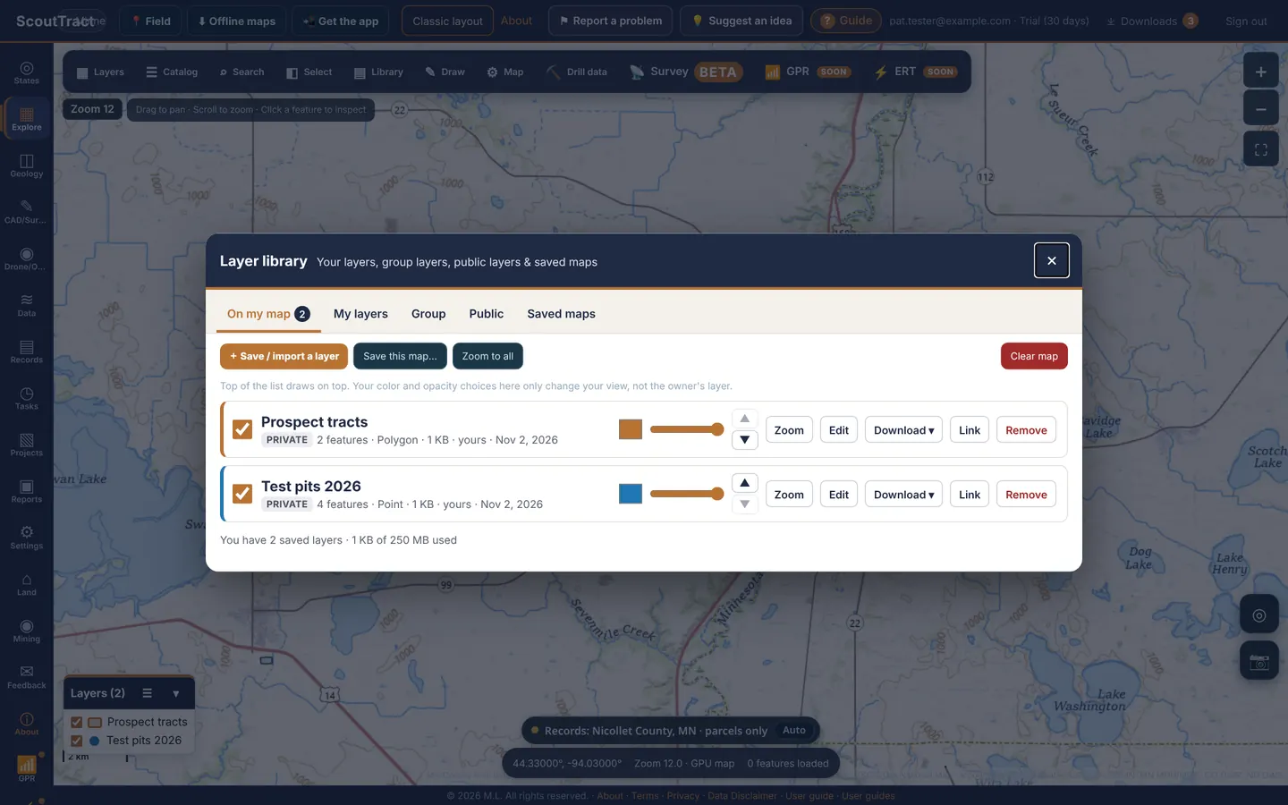
| Tab | What it holds |
|---|---|
| On my map | The library layers on your map now. Change colour and opacity, move a layer up or down, Zoom, Edit, Download, copy a Link or Remove it. Clear map removes them all. Colour and opacity only change your view, not the owner's layer. |
| My layers | Every layer you saved. + Save / import a layer from a file (GeoJSON, KML/KMZ, zipped shapefile, GPX, CSV or DXF, up to 25 MB), from a file imported in Layers & services, or from a Survey project. |
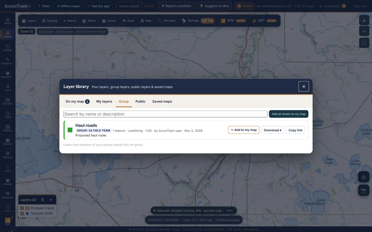
| Group | Layers people in your groups shared with the group. + Add to my map to use one. |
| Public | Layers anyone signed in to ScoutTract can add. |
| Saved maps | Save this map… keeps the set of layers on your map so you or your group can open it again. |
| My groups | Only for group admins: members and the group's layers. |
Who can see a layer
- Private: only you. This is the default.
- Group: members of the groups you choose. You can only share with groups you belong to.
- Public: anyone signed in to ScoutTract.
Change it any time with Edit. Your library space is shown under the list (for example 1 KB of 250 MB used).
The map legend
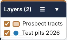
When library layers are on your map, a small Layers legend appears at the bottom left of the map. Untick a layer there to hide it for a moment, or use ☰ to open the library. A window docked on the left, such as Area & layers, no longer covers the legend; it moves to the right of the window.
9 · Parcel search: address, parcel ID, owner
Address, parcel ID or coordinates
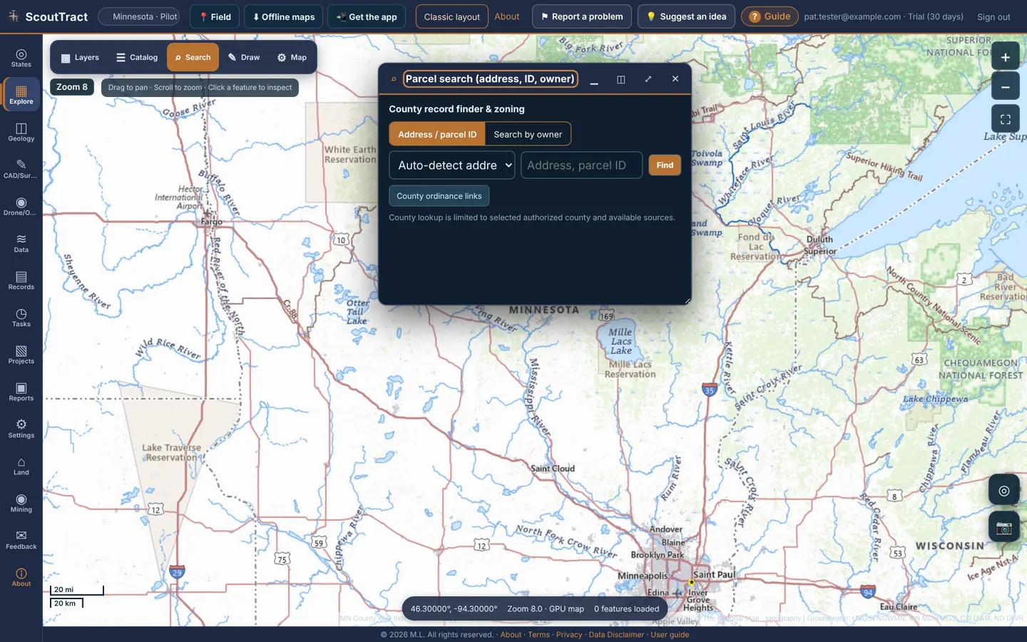
- Click ⌕ Search on the map bar. The window is called County record finder & zoning.
- Keep the Address / parcel ID tab. Type a street address, a parcel ID or a latitude,longitude such as
46.87,-96.76. Auto-detect works out which it is, or choose Street address, Parcel ID or WGS84 lat,lon. - Click Find. The map flies there and opens the parcel. County ordinance links opens the county’s zoning and ordinance pages.
Parcel ID search works county-wide in Minnesota and Colorado, and in the visible map area in North Dakota.
Search by owner (every parcel an owner holds in a state)
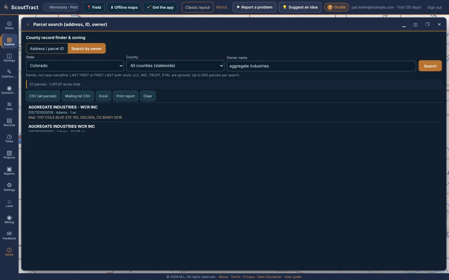
- Open the Search by owner tab.
- Choose the state. Leave the county on All counties (statewide), or pick one county to narrow it.
- Type the owner name and click Search.
Smith John,John Smithandsmithall work. Capitals and the words LLC, INC, TRUST and ETAL are ignored, soAcme Ranchalso finds ACME RANCH LLC. Each word must be a whole word of the owner name (Langdoes not find LANGE), and exact name matches are listed first. - The list shows owner, parcel ID, county, acres, site address and, where the county publishes it, the mailing address (where the tax bill goes), with the total acres at the top. Every match is outlined in copper and the map zooms to fit them.
- Click a row to fly to that parcel and open its information.
Exports
| Button | What you get |
|---|---|
| CSV (all parcels) | One row per parcel: owner, mailing address (line 1, city, state, ZIP), site address, parcel ID, county, state, acres, legal description |
| Mailing list CSV | One row per owner and mailing address (Name, Address, City, State, ZIP, parcel count, total acres), ready for mail merge or labels. Parcels with no published mailing address are left out; you see how many |
| Excel | Both lists as sheets in one .xlsx file |
| Print report | A printable table with total acres |
| Clear | Clears the results and outlines |
Exports need the export right on your account. Each search asks the state or county service live and shows up to 500 parcels; add a first name or pick a county if there are more. You can run about 10 owner searches a minute, and you only see parcels in counties your account can open.
| State | Owner search | Owner mailing address |
|---|---|---|
| Minnesota | 45 of 87 counties (MnGeo open parcels) plus Scott County. In other counties the county list shows not available; a few counties share only public land and show limited. | Yes |
| Colorado | 41 of 64 counties (state public parcel composite). Other counties show not available. | Yes |
| Montana | Yes. All 56 counties (Montana Cadastral). | Yes |
| Wyoming | Yes. Statewide 2024 parcels (Office of State Lands). | Yes |
| Arizona | Maricopa, Pinal and Pima counties. | Yes |
| New Mexico | Doña Ana and Sandoval counties. | Doña Ana yes; Sandoval no |
| Utah | Utah County. | Yes |
| Iowa | Yes, from the 2017 snapshot (owners may have changed). Statewide it matches names that start with your words; pick a county to match anywhere in the name. | No |
| North Dakota | Yes. All 53 counties (ND GIS Hub tax roll). | Yes |
| Nebraska | Douglas and Lancaster counties. | Yes |
| Texas | Not available: the statewide parcel service does not allow searching by owner name. | — |
Owner names come from county assessor data and are spelled many ways (JOHN SMITH, SMITH JOHN A, SMITH J & M). Try the last name alone if you miss parcels. ScoutTract does not buy or look up phone numbers or people-search data. This is not a title search.
10 · Legal descriptions: PLSS sections and Texas surveys
- Click a parcel: the parcel information lists meridian, township, range and section, with links to BLM GLO plats and field notes.
- Phone pin: on a phone the dropped-pin card also shows the PLSS section.
- North Dakota: turn on PLSS sections (zoom 10+) and PLSS section corners (zoom 12+).
- Colorado: Colorado BLM PLSS reference overlays (townships, sections and survey corners) for one county at a time.
Township / range / section search
In Iowa, Arizona, Montana, Wyoming, Nebraska, New Mexico and Utah, the PLSS land lookup card appears with the layers.
- Enter the township (e.g.
79N), range (e.g.24W) and, if you like, a section from 1 to 36. Choose the meridian where a state has more than one (Arizona: Gila and Salt River, Navajo or San Bernardino; Wyoming: Sixth Principal or Wind River; Utah: Salt Lake or Uintah Special). - Click Find & zoom. The section is outlined and the map zooms to it.
- Leave Click the map to identify township / section ticked to identify any spot by clicking it.
Texas: abstract, survey, block and section
- Pick Texas. The Texas land survey lookup card appears.
- Choose the county, then type any of abstract (e.g.
46orA-46), survey (e.g.T&P RR CO), block and section. - Click Find & zoom, or click the map to identify the survey and abstract there.
- Turn on Original Texas Land Survey tracts under State data layers for the lines and labels (zoom 12+).
North Carolina: lat/lon or State Plane (no PLSS)
North Carolina was never surveyed into PLSS sections. Land is described by metes and bounds in the deed, so the parcel and cover sheet say PLSS not available.
- Pick North Carolina. The North Carolina coordinates card appears.
- Enter a latitude and longitude, or a NC State Plane easting and northing in US survey feet (EPSG:2264) or meters (EPSG:32119).
- Click Convert & zoom. Clicking the map also shows the State Plane coordinates of that point.
- Turn on NC OneMap statewide parcels under State data layers (zoom 15+) and click a parcel for the owner, value and deed legal.
11 · Parcel information: owner, GLO, FEMA, tax and zoning
- Zoom in until parcel boundaries draw (zoom 15 in most counties).
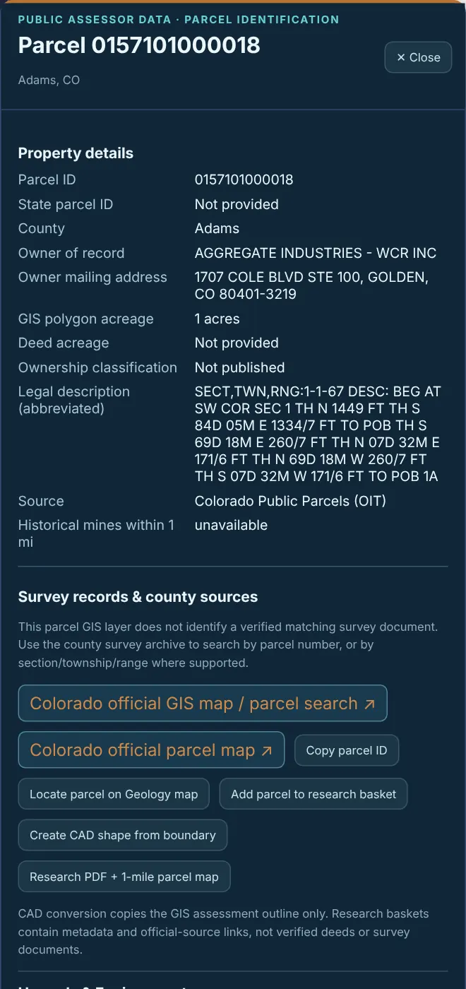
- Click a parcel. The Parcel window with the parcel ID and county.
What it shows, where the public data exists:
| Part | What is in it |
|---|---|
| Property details | Parcel ID, state parcel ID, county, owner of record, owner mailing address, GIS polygon and deed acreage, ownership classification, legal description, source, historical mines within 1 mile |
| Survey records & county sources | Links to the county survey archive and recorder |
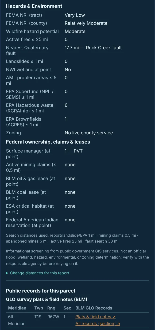
| Hazards & Environment | FEMA National Risk Index, wildfire hazard, active fires, nearest Quaternary fault, landslides, NWI wetlands, abandoned mine lands, EPA Superfund, hazardous waste (RCRA) and brownfield counts nearby. Change distances for this report sets the search radius |
| Federal ownership, claims & leases | Surface manager, active mining claims, BLM oil and gas and coal leases, critical habitat |
| GLO survey plats & field notes (BLM) | Meridian, township, range and section with Plats & field notes and All records (section) links to BLM GLO Records |
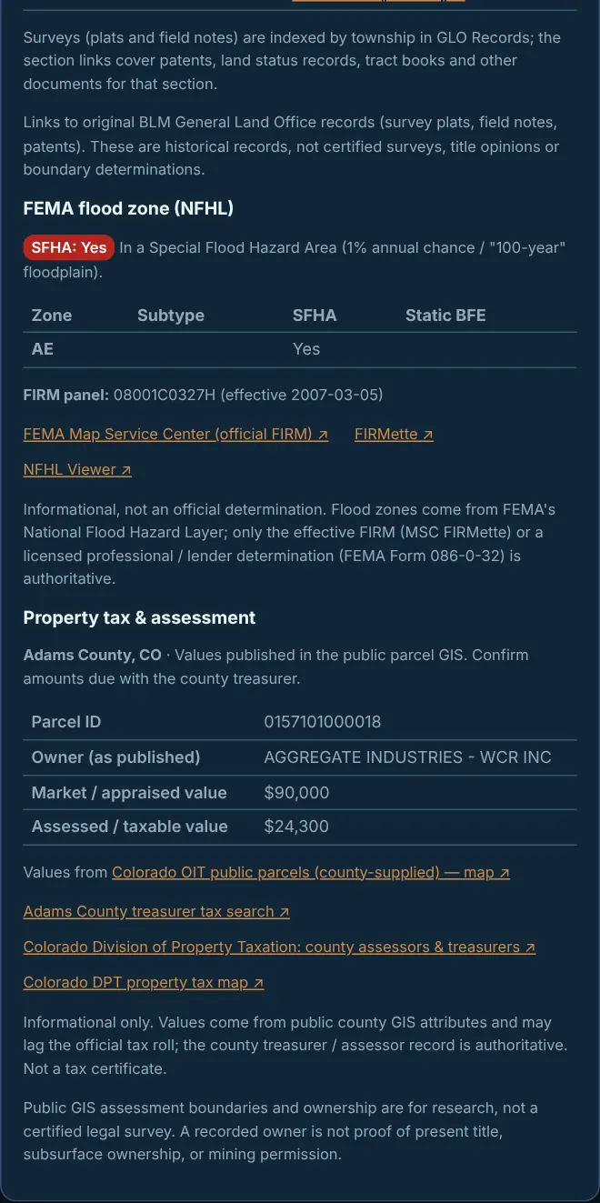
| FEMA flood zone (NFHL) | SFHA yes/no, zone and subtype, static BFE, FIRM panel and effective date, with links to the FEMA Map Service Center (official FIRM), FIRMette and the NFHL Viewer |
| Property tax & assessment | Owner, market / appraised value and assessed / taxable value as published, with links to the county treasurer and assessor and state property tax pages |
- Research PDF + 1-mile parcel map builds a report for this parcel (see Reports).
- + Add to selection adds it to a multi-parcel selection.
- Save boundary to a CAD project copies the boundary into a project as an editable DXF.
- Zoning: use County ordinance links in Parcel search for the county’s zoning pages. Where an administrator has converted a county zoning PDF, the zoning appears as a map layer.
Parcel sources: Minnesota, Colorado, North Dakota and Texas use public county or state parcel services; Arizona has Maricopa, Pinal and Pima parcels and State Trust land; Montana, Wyoming, Nebraska, Utah and North Carolina (NC OneMap, all 100 counties) have statewide layers (Utah publishes no owner names); New Mexico has the State Engineer’s county compilation (zoom 15+); Iowa only has a 2017 snapshot (tick Also look up Iowa parcel (2017 snapshot) in the PLSS lookup).
Public parcel lines and values are for research. A recorded owner is not proof of present title or mineral ownership; the county treasurer or assessor record is authoritative.
12 · Selecting several parcels and the cover sheet
Pick up to 200 parcels, each in its own colour and number, then view or export a cover sheet with parcel IDs, counties, acres, owners, legal descriptions and a map. You choose which of 29 items in 8 groups go on it, and can save your choices as named configurations.
- Click ◧ Select on the map bar (or ◧ Select parcels on map in the Search window).
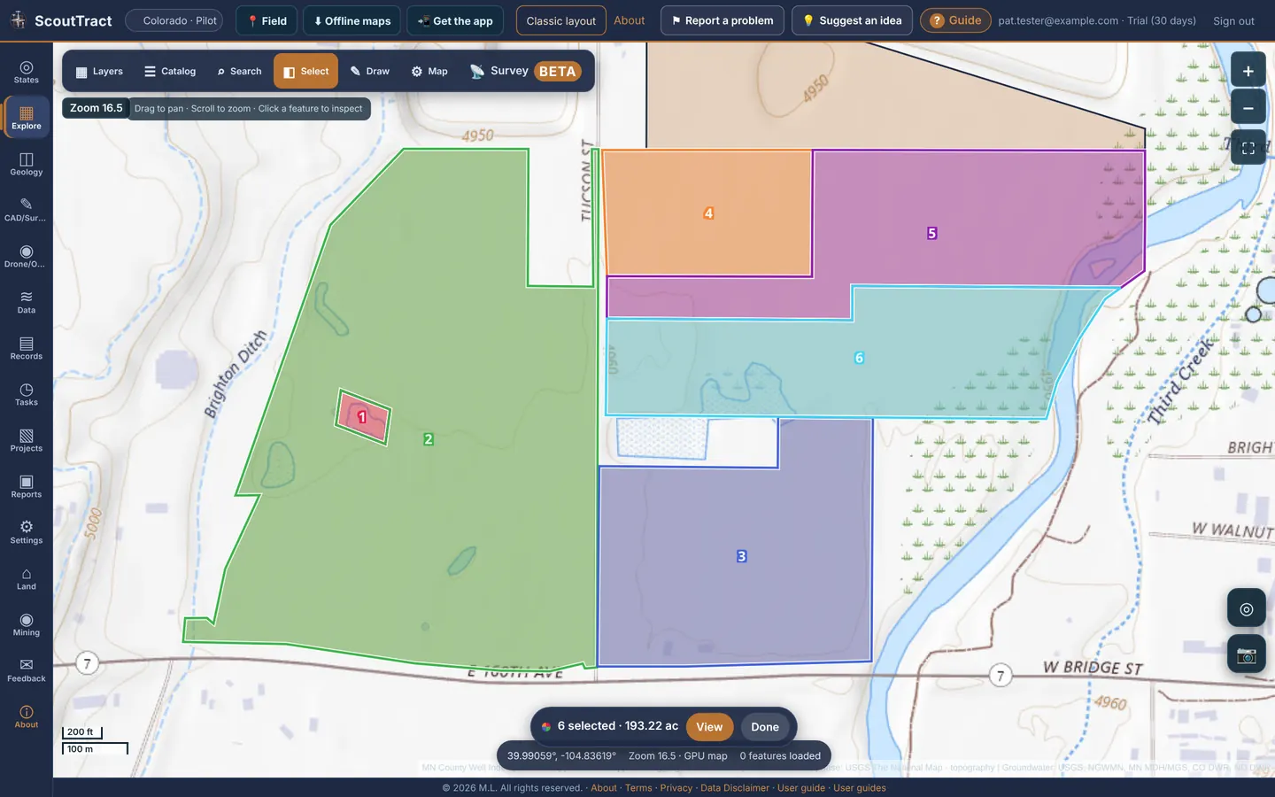
- Click parcels. Each is looked up live, outlined in its own colour and numbered. Click a selected parcel again to remove it. Pan and zoom freely: the selection stays, even if you reload.
- From owner search results, click + Select on a row or Add all to selection. In a parcel window, click + Add to selection.
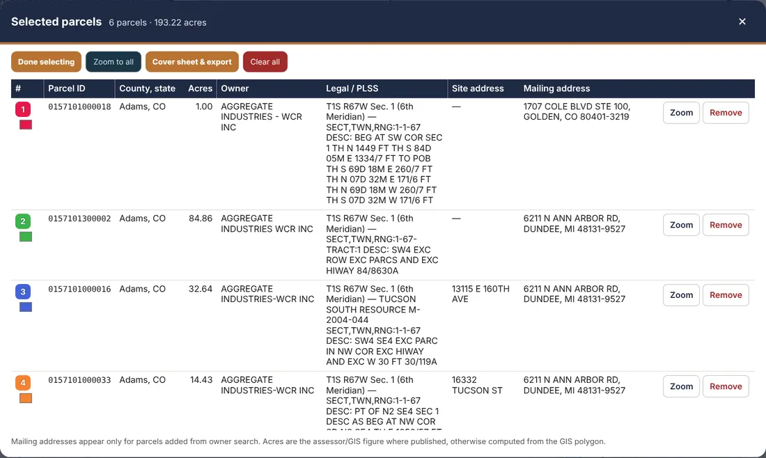
- The bar at the bottom of the map shows how many parcels and acres are selected. Click View for the Selected parcels list: colour and number, parcel ID, county and state, acres, owner, legal / PLSS (Texas: abstract and survey) and site address. Change a colour with its swatch, Zoom to one or Zoom to all, Remove one or Clear all. Done selecting turns selecting off.
- Click Cover sheet & export. Edit the title, date and Prepared by name, check the map and table, then click View PDF or download PDF, CSV, Excel, GeoJSON or KML.
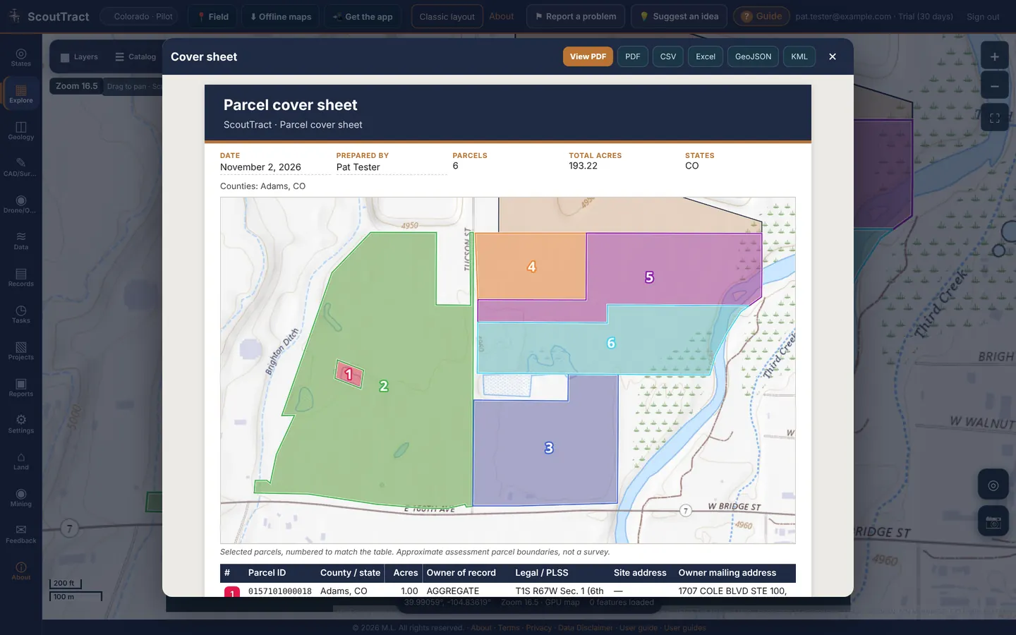
| On the cover sheet | Details |
|---|---|
| Header | ScoutTract navy and copper band, your title, the date and who prepared it (defaults to today and your profile name; both editable) |
| Map | The selected parcels in their colours with matching numbers |
| Table | Number and colour, parcel ID, county / state, acres, owner of record, PLSS or Texas survey plus the legal description, site address, and a totals row |
| Mailing address | Only for parcels added from owner search |
| Notes and footer | Data sources and date, how acres were measured, and the disclaimer footer (when the PDF footer is on) |
Choosing what goes on the cover sheet
Click Sections & saved configurations at the top of the cover sheet. Every item is a checkbox, and a group checkbox turns the whole group on or off (it shows a dash when only some are on). Defaults, All and None are quick resets, and the count on the right shows how many are on (for example 20 of 29 items). What you tick drives the preview, the PDF, the CSV and Excel columns, and the GeoJSON and KML attributes. Only ticked items are fetched, so a shorter sheet is also faster. Your last choice is remembered on this device. An item with no data for a state in the selection shows Not available: <state> under it.
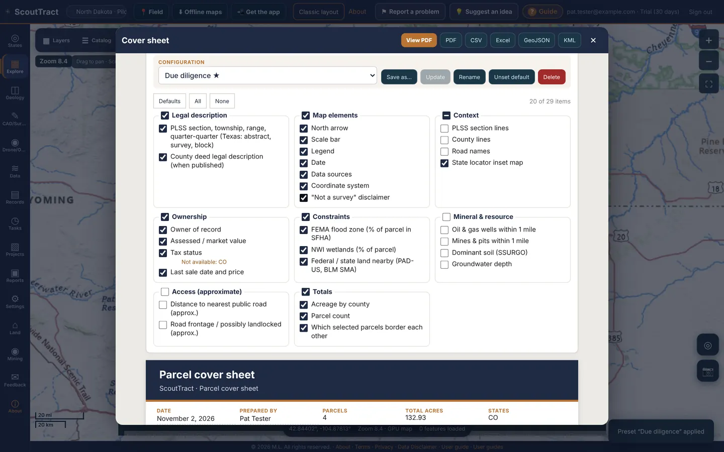
| Group | Items (✓ = on by default) |
|---|---|
| Legal description | PLSS section, township, range, quarter-quarter (Texas: abstract, survey, block) ✓; County deed legal description (when published) ✓ |
| Map elements | North arrow ✓, Scale bar ✓, Legend ✓, Date ✓, Data sources ✓, Coordinate system ✓, “Not a survey” disclaimer ✓ |
| Context | PLSS section lines, County lines, Road names, State locator inset map ✓ |
| Ownership | Owner of record ✓, Assessed / market value ✓, Tax status ✓, Last sale date and price ✓ |
| Constraints | FEMA flood zone (% of parcel in SFHA) ✓, NWI wetlands (% of parcel) ✓, Federal / state land nearby (PAD-US, BLM SMA) ✓ |
| Mineral & resource | Oil & gas wells within 1 mile, Mines & pits within 1 mile, Dominant soil (SSURGO), Groundwater depth |
| Access (approximate) | Distance to nearest public road (approx.), Road frontage / possibly landlocked (approx.) |
| Totals | Acreage by county ✓, Parcel count ✓, Which selected parcels border each other ✓ |
Saved configurations
- Tick the items you want, then click Save as… and give it a name such as Due diligence or Mineral review. It stores the ticked items with the current title and prepared-by name.
- Pick a configuration from the Configuration list to apply it. If you change any boxes afterwards it is marked modified; click Update to save the change into it. Custom (not saved) means no configuration is applied.
- Rename and Delete do what they say (Delete asks first). Make default marks the configuration used wherever you have not chosen yet; it shows ★ in the list, and Unset default clears it. Your first saved configuration starts as the default.
Configurations are saved to your account, up to 30, so they follow you between computer and phone. Nobody else can see them.
Exports need the export right for every state in the selection. Acres are the assessor or GIS figure where the county publishes one, otherwise computed from the parcel polygon. Flood, wetland, access and groundwater figures are approximate screening values. The cover sheet is not a survey.
13 · Drawing and measuring
The draw toolbar floats on the map, so the map keeps its full size while you work.
To open it: click ✎ Draw on the map bar (classic layout: Draw, measure & label on the map).
| Button | What it does |
|---|---|
| ✋ Pan | Move the map; stops drawing |
| • Point | Drop a point |
| ╱ Line | Click points, then Done |
| ⬠ Shape | Draw a polygon: click corners, then Done |
| T Text | Place a text label |
| 📏 Dist. | Measure a distance |
| ▱ Area | Measure an area |
| ↶ Undo | Undo the last point or shape |
| ✓ Done | Finish the shape or measurement (or press Enter / double-click) |
| ⌫ Clear | Clear measurements or discard unsaved drawings |
| ⋯ More | Colour, label, project, use selected parcel, save and load |
| ▾ Hide | Shrink the toolbar to a small Draw button |
The chip above the toolbar shows the live length or area and the next step, for example Polygon: tap the map to add vertices.
Save to a project
- Click ⋯. Pick a colour and label, and choose a project.
- Click Save drawings to project. Load saved drawings brings them back later.
- Use selected parcel copies the selected parcel outline as a shape. Close drawing tools closes the toolbar.
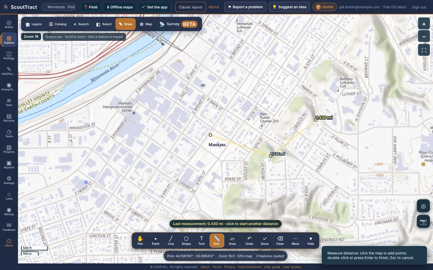
Measurements are geodesic and approximate, not survey grade.
14 · Flood, hazards and federal land
FEMA flood zones
- Open FEMA flood zones (NFHL) in the layer list and turn on Flood hazard zones · FEMA NFHL.
- From zoom 8 the map shades where FEMA digital flood maps exist.
- From zoom 12 you see the flood zone polygons: 1% annual chance (A, AE, AO, AH, V, VE) and 0.2% annual chance.
- Click a parcel for its zone, FIRM panel and effective date.
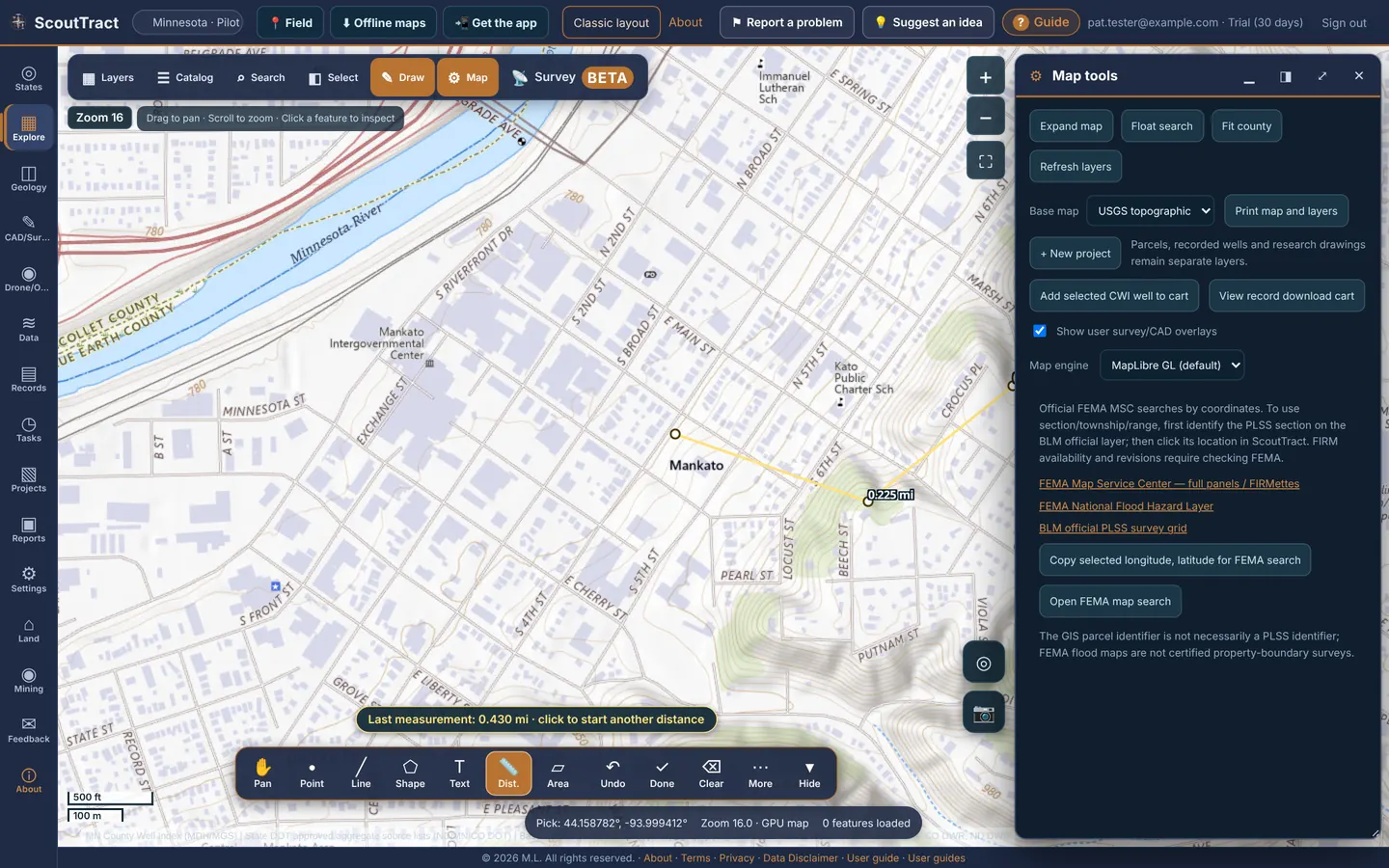
⚙ Map tools adds links to the FEMA Map Service Center, the NFHL viewer and BLM PLSS, plus Copy selected longitude, latitude for FEMA search and Open FEMA map search.
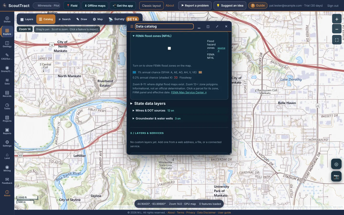
Hazards, environment & federal land
National Risk Index, wildfire hazard and current fires, Quaternary faults, landslide susceptibility, wetlands, abandoned mine lands, and EPA Superfund, RCRA and brownfield sites. The federal reference layers add land ownership, BLM mining claims and leases, wilderness, critical habitat, pipelines, soils, the USGS state geologic map compilation, gravity and magnetics. A layer that cannot be reached says unavailable without affecting the others.
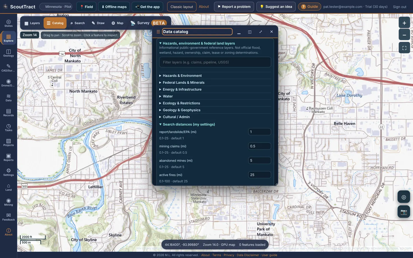
Flood and hazard layers are informational, not an official flood determination. FEMA’s Map Service Center FIRMs are authoritative.
15 · Wells and groundwater
Open Groundwater & water wells in the layer list.
- Depth to water on state well records (Minnesota CWI, Colorado DWR permits, North Dakota imports), coloured by depth (zoom 11; labels from zoom 13).
- Monitoring wells (USGS, NGWMN, MN DNR, CO DWR), from zoom 8. Click one for a small water-level chart. A white ring means it was read in the last 2 years; yellow is older.
- Groundwater surface (estimate): click Surface for view or Draw area to build a water-table or depth-to-water surface with contours and a CSV download (zoom 9+).
- Context overlays: USGS principal aquifers, and depth to bedrock from Minnesota well logs.
State well layers include Minnesota County Well Index, North Dakota oil and gas wells, Colorado ECMC wellbores and DWR permits, Texas RRC wells, Iowa GeoSam wells, Arizona ADWR wells, Montana GWIC and oil and gas wells, Wyoming WOGCC wells and State Engineer permits, Nebraska DNR registered wells, New Mexico OCD wells and OSE points of diversion, Utah DOGM wells and water-right points of diversion, and North Carolina DEQ oil and gas test wells and groundwater wells.
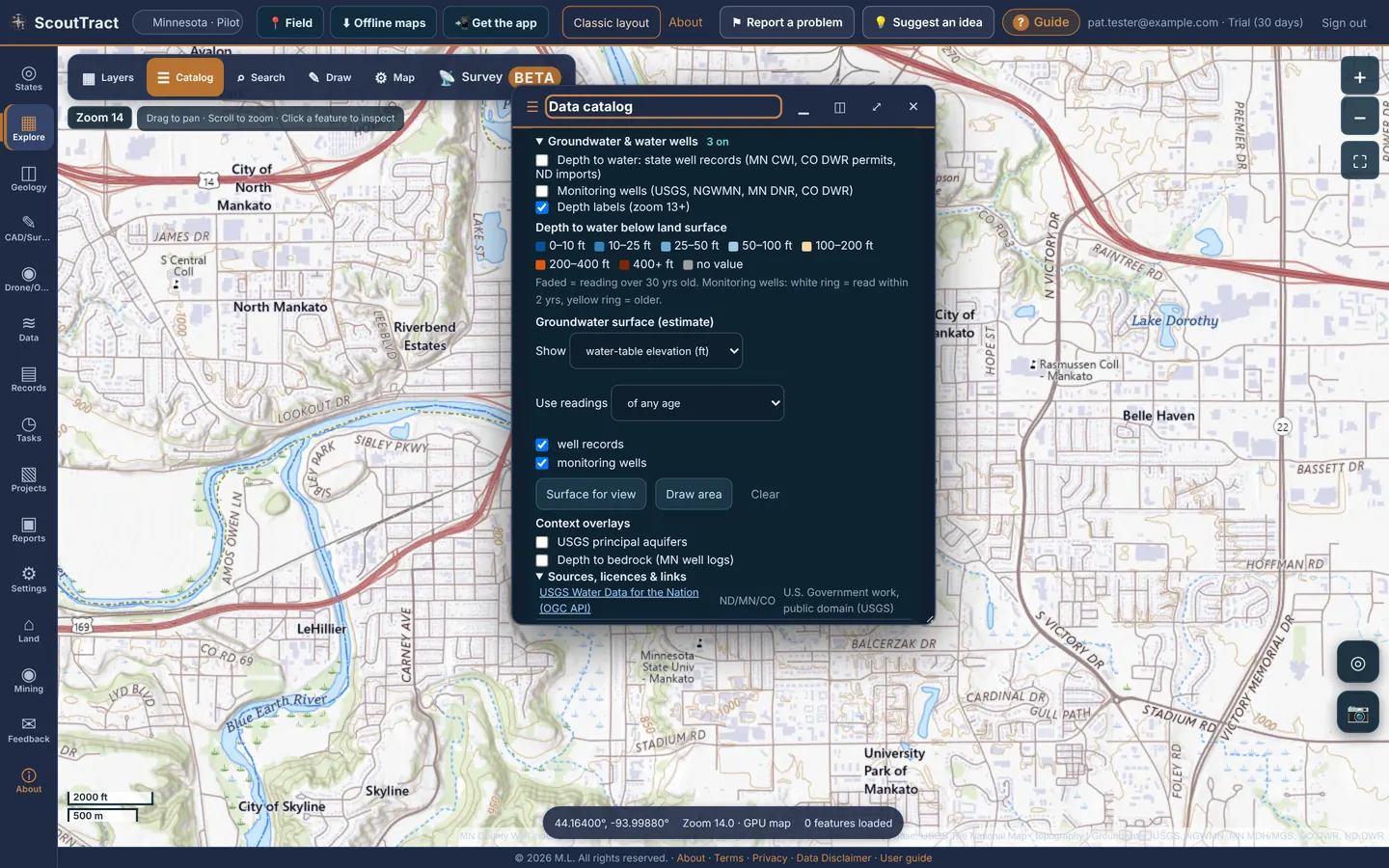
Groundwater values are estimates from public records, not a survey. Old readings are faded.
16 · Drill data (Beta)
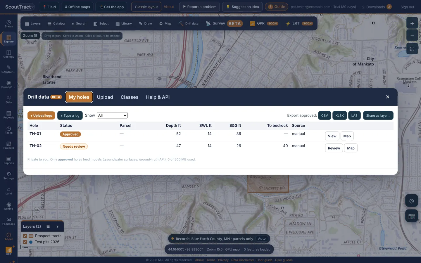
Keep your own drill holes and test pits with their logs: depths, materials, static water level and the sand-and-gravel picture. Click Drill data in the map toolbar. From a parcel you can also choose + Add drill data, which links the hole to that parcel.
| Tab | What it does |
|---|---|
| My holes | Your holes with status, parcel, depth, static water level (SWL), sand & gravel and depth to bedrock. View or Review a hole, or Map to fly to it. Export approved as CSV, XLSX or LAS, or Share as layer… into the layer library. |
| Upload | Upload logs: scanned or photographed driller's logs (PDF, JPG, PNG, HEIC, TIFF), LAS 2.0/3.0, or CSV/Excel drill-hole tables. Or + Type a log by hand. Set the location with your GPS, by tapping the map, or by typing lat/lon. |
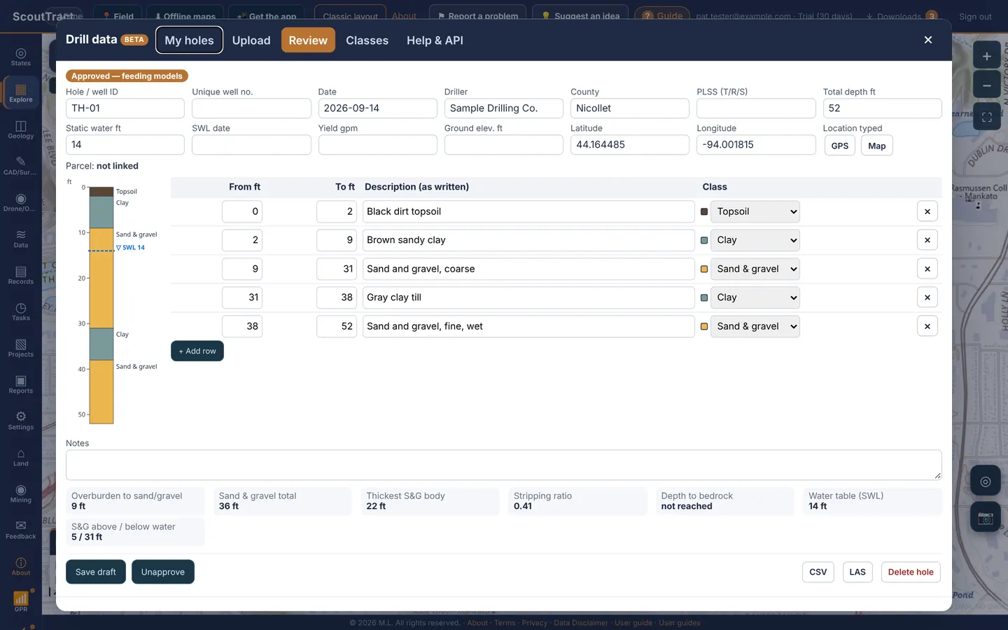
| Review | Check every row against the original: from/to depths, the description as written, and the material class. The strip log on the left updates as you edit. |
| Classes | The material classes used to colour logs and work out sand & gravel totals. |
| Help & API | How the numbers are worked out, and the ground-truth API for approved holes. |
- Upload or type the log.
- Open it in Review, correct anything the reader got wrong and fill in missing fields. Handwritten logs must be checked cell by cell.
- Click Approve. Only approved holes feed models such as groundwater surfaces, and only approved holes export.
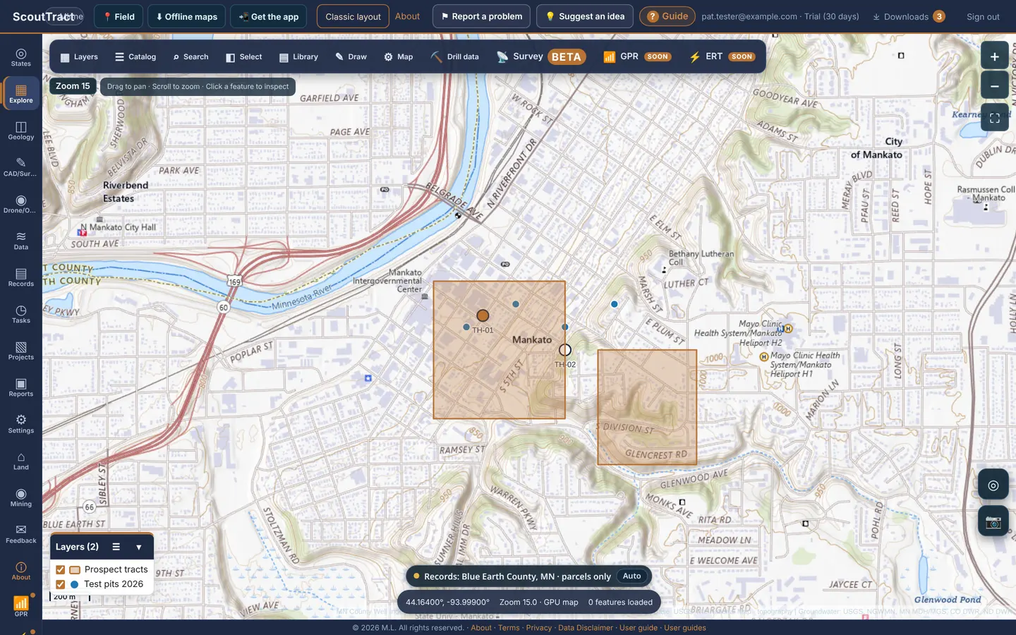
Drill data is private to you (500 MB of storage). It is in Beta: check the numbers against the original log before you rely on them.
17 · Mines and DOT gravel pits
Open Mines & DOT sources in the layer list.
- US Historical Mines (USGS MRDS): filter by development status (producer, past producer, prospect, occurrence, plant). Shown at all zooms, clustered when zoomed out.
- DOT approved aggregate sources: turn on the states you want. Filled dots use the coordinates the DOT published (or ones derived from PLSS, address or name).
- Material class filters both: Quarry (crushed or dimension stone), Sand & Gravel and Unknown.
- Approximate locations: DOT entries without coordinates are placed from the listed address or the town or county centre and drawn as hollow rings. Click a ring to see how good the match is.
- All 50 state lists links to every state DOT’s list.
State layers add more: Iowa quarries and historic coal mines, Arizona active mines and aggregate plants, Minnesota mineral leases, Montana DEQ opencut (gravel) and hard rock sites, Wyoming county pits and limited mining operations, New Mexico MMD registered mines, Utah mineral occurrences and SITLA sand and gravel contracts.
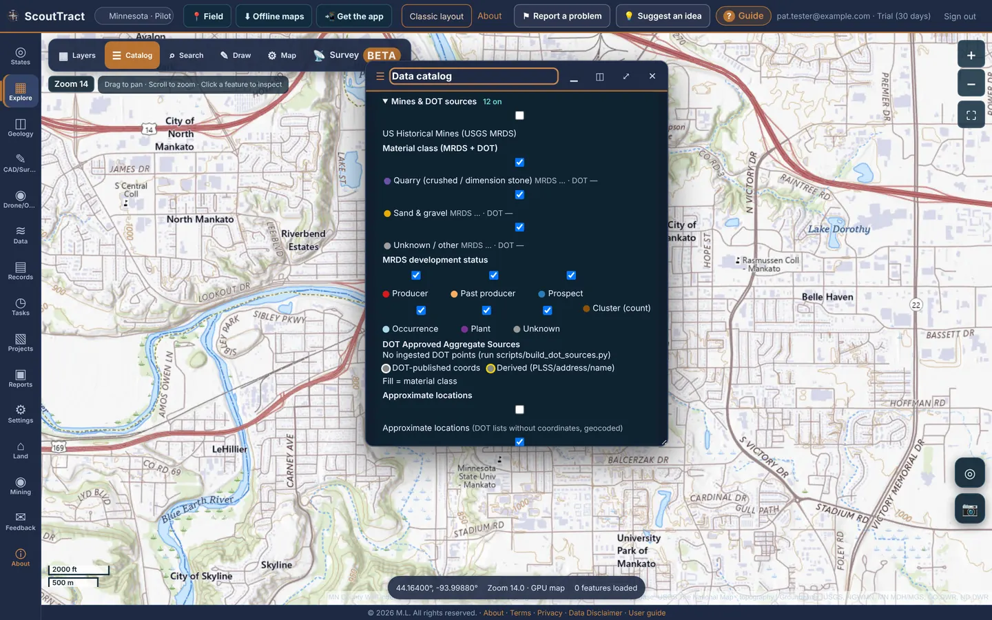
Approximate locations can be miles off. Verify a pit or quarry with the DOT or the operator before relying on it.
18 · Field capture and offline maps
Field capture: a photo and a note at your position
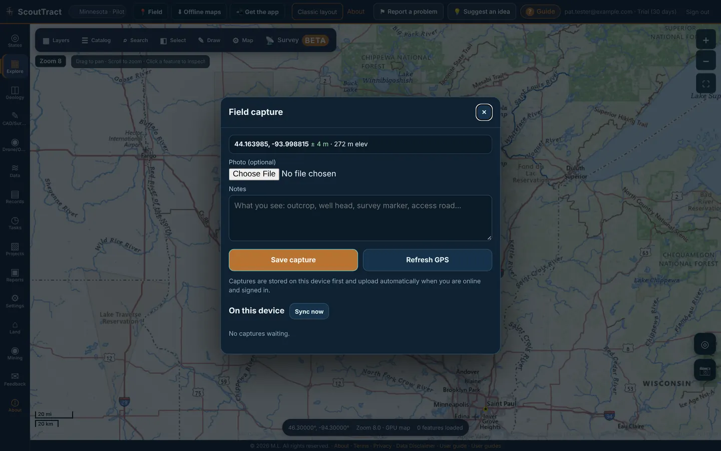
- Click 📍 Field in the top bar.
- The window shows your coordinates, accuracy and elevation (for example 44.163985, -93.998815 ± 4 m · 272 m elev). Click Refresh GPS for a new fix.
- Add a Photo (optional) and Notes, then click Save capture.
Captures are stored on this device first and upload automatically when you are online and signed in. On this device lists any still waiting; Sync now sends them.
Offline maps: save an area before you lose signal
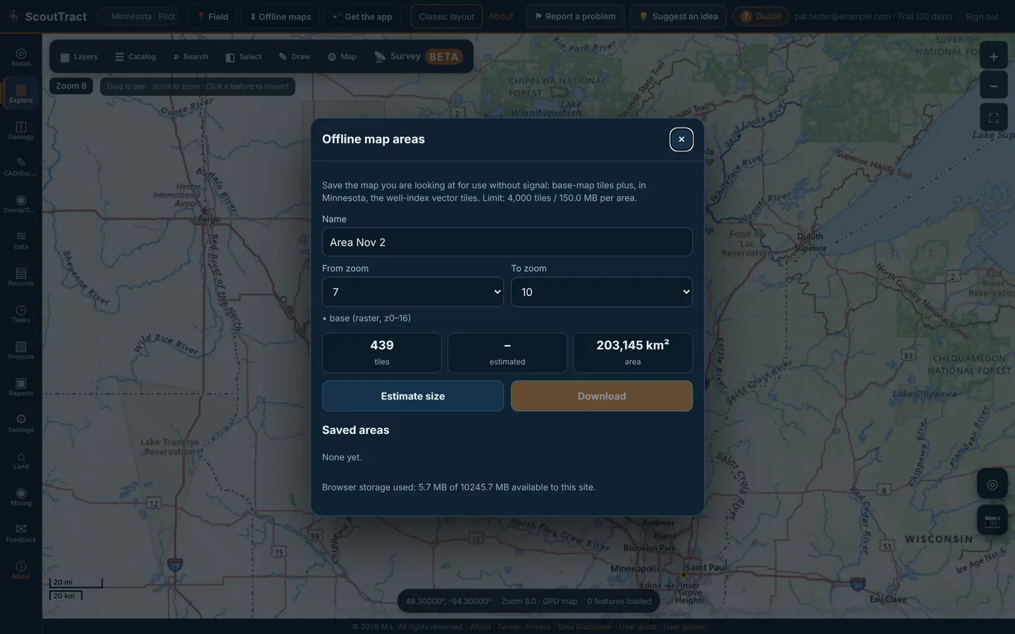
- Move the map to the area you need.
- Click ⬇︎ Offline maps in the top bar.
- Give it a Name and choose From zoom and To zoom (6 to 16). The window shows the tile count, estimated size and area; click Estimate size to update it.
- Click Download. The area appears under Saved areas with the browser storage used.
Offline areas hold the base-map tiles plus, in Minnesota, the well-index vector tiles. The limit is 4,000 tiles / 150 MB per area. Parcel lookups, owner search and most state layers still need a signal.
19 · Geology, cross sections and 3D
Geology layers are in the layer list for each state: for example NDGS bedrock and surface geology in North Dakota, MGS depth to bedrock in Minnesota, Iowa Geological Survey bedrock and karst, the Geologic Map of Arizona with faults and earth fissures, and the 1:500,000 state geologic maps of Montana, Wyoming, New Mexico and Utah (Nebraska uses the USGS compilation).
The Geology tab (3D geology & cross sections)
- Click Geology in the left rail. Pick the state and one or more authorized counties, or click Use Explore selection. Fit selected county zooms to it.
- Draw an area with Draw area: 2 corners, or a cross-section line with Draw A–B: 2 points.
- Click Find all well records or Create observed A–B section. Logged intervals show as separate well columns, without inferred continuity.
- Export with Export well records CSV, a wells + stratigraphy ZIP, or an A–B section PDF · 11×17.
Show 3D borehole locations on 2D map pins the logged wells in the research area; Refresh well overlay updates them.
3D viewer
- Observed well logs (3D) and Regional interpreted model: Minnesota, with GeoTIFF, 3D PDF, HTML and GLB exports.
- USGS 3DEP surface terrain (CO / ND): land-surface elevation only, not underground geology.
- Choose the 3D view in the Geology tab.
- Press Open 3D viewer. Drag to orbit and scroll to zoom.
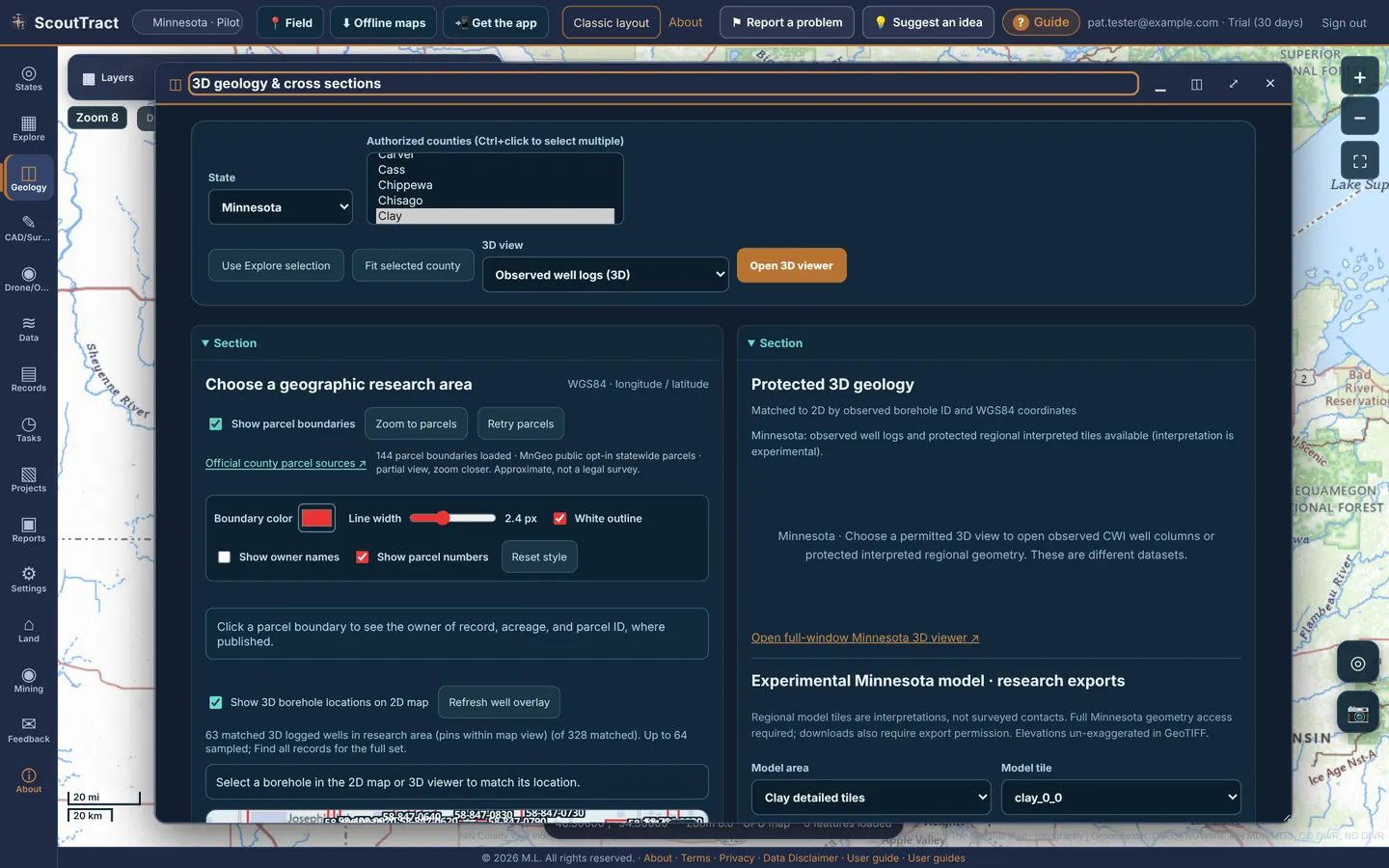
Pick a small area for 3D; big areas take longer. The state list here covers Minnesota, North Dakota and Colorado during the pilot.
20 · Reports, printing and PDFs
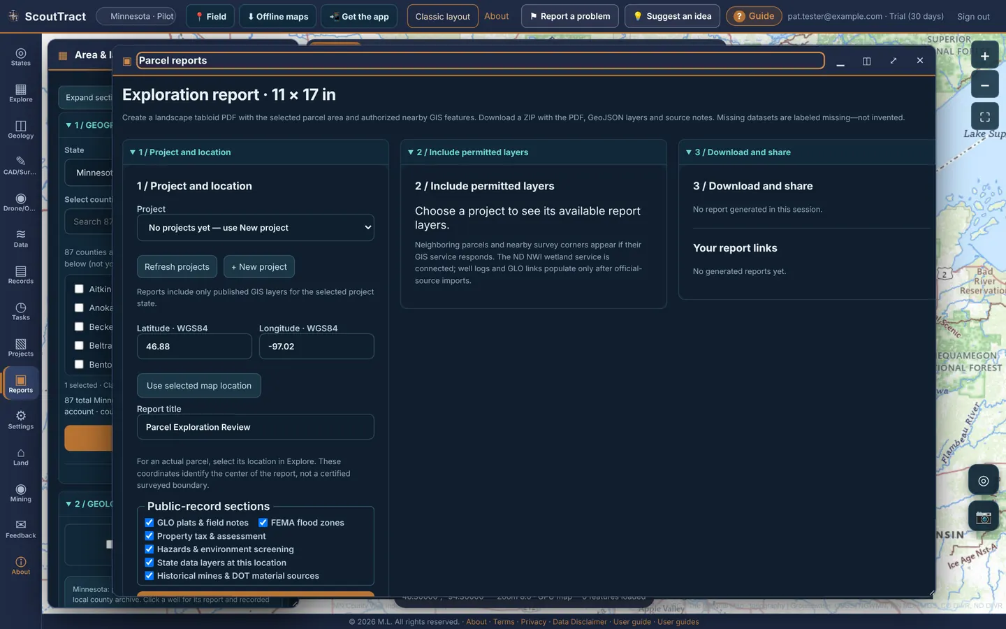
Click Reports in the left rail. The page is called Parcel reports and has two report types.
Exploration report · 11 × 17 in
- 1 / Project and location: pick a project (or + New project), then click a spot on the map and Use selected map location, or type the latitude and longitude (WGS84). Give the report a title and tick the public-record sections you want.
- 2 / Include permitted layers: choose the layers to add.
- Click Generate PDF + ZIP. A progress list shows each step.
- 3 / Download and share: download the 11×17 PDF and the ZIP of source data. Print view opens a printable page. Your report links lists earlier reports.
Research PDF: selected parcel and 1-mile neighborhood
- Select a parcel on the map (or use Research PDF + 1-mile parcel map in its window).
- Optionally upload up to 2 design plans (PDF, PNG, JPG or DXF) with Upload to project.
- Tick the report sections: parcel + 1-mile map, wells & cross sections, survey / water / protection screening, nearby parcel ID + owner register, GLO, FEMA, tax, hazards, state layers, mines / DOT.
- Click Generate Research PDF, or PDF + source data ZIP, or Print view.
Print the map
⚙ Map tools → Print map and layers prints the current map with its layers and legend. Other PDFs: the cover sheet (Selecting several parcels), owner search Print report, geology area and A–B section PDFs, and the Records cart PDF.
Add your company name and logo to report PDFs under Settings → Brand your reports.
21 · Projects and CAD/Survey drafting
Projects
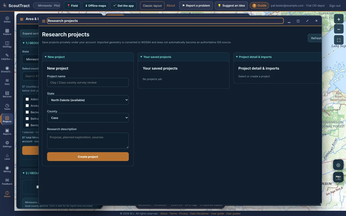
- Click Projects in the left rail. Under New project, enter a project name, state, county and a research description, then click Create project.
- Open it under Your saved projects. Project detail & imports takes CSV, KML, KMZ, DXF or GeoJSON; pick the coordinate system if it is not latitude/longitude.
- Save drawings and parcel boundaries to the project from the map.
Your projects are private to your account.
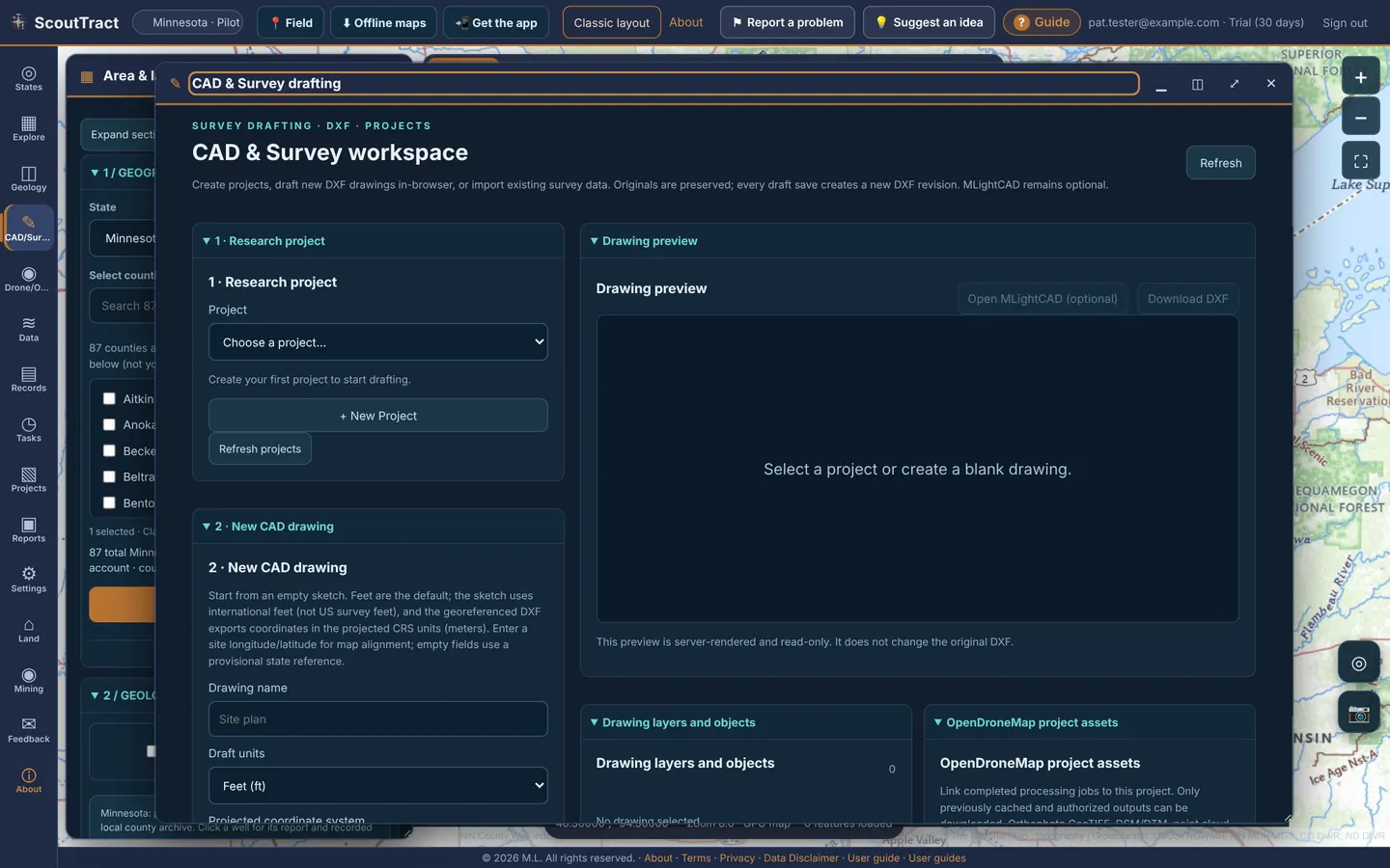
CAD/Survey workspace
Click CAD/Survey in the left rail.
- 1 Research project: pick or create the project.
- 2 New CAD drawing: name it, choose draft units (ft or m), a projected coordinate system (UTM 14N or 15N, Minnesota State Plane North / Central / South, North Dakota State Plane North / South) and the origin, then + Create Blank Drawing.
- 3 Import survey DXF: choose the source coordinates and Import into project.
- 4 Project drawing library: open a drawing to preview it, list its layers and objects, and Download DXF.
- Project map files: Import KML / KMZ.
- Map selection / survey reference: Save Explore selection and Show drawing on Explore map.
- Open MLightCAD (optional) opens a browser CAD editor where it is installed (see Known limits).
22 · Records, downloads and agency data
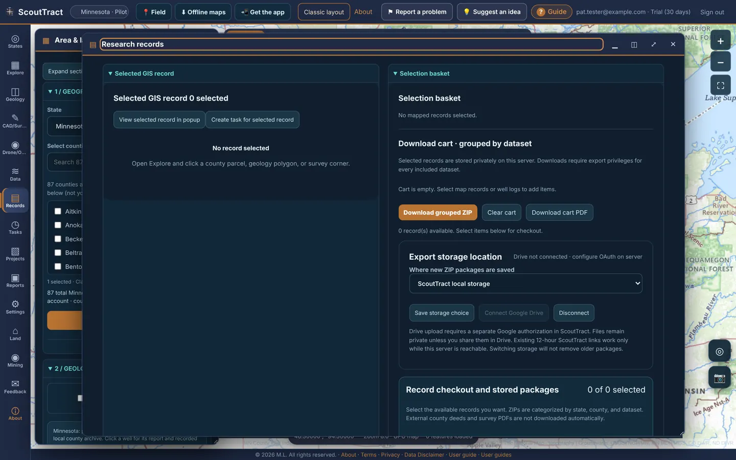
Records (research records)
Click Records in the left rail.
- Selected GIS record: View selected record in popup or Create task for selected record.
- Selection basket and the Download cart grouped by dataset: Download grouped ZIP, Download cart PDF, Clear cart. In Minnesota, Add selected CWI well to cart is in Map tools.
- Export storage location: ScoutTract local storage or your own Google Drive (private; needs Connect Google Drive). Save storage choice.
- Record checkout and stored packages: tick records, name the package and Checkout selected → Save ZIP. Packages are kept 30 days; a share link is valid for 12 hours (Copy link).
- Export selected layer (GeoJSON), Saved research locations (your saved points and pins), Parcel research references (Export parcel reference CSV) and the Well record download cart.
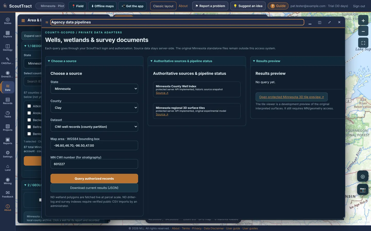
Data (agency data pipelines)
- Click Data in the left rail. Choose a source: state, county and dataset (for example CWI well records (county partition) or One CWI well lithology log), and a map-area box or a Minnesota CWI number.
- Click Query authorized records. The Results preview shows the rows; Download current results (JSON) saves them.
Authoritative sources & pipeline status lists each agency feed and when it was last checked.
23 · Background exports, My downloads and export destinations
Zipped and large exports, such as an owner-search bundle, a Survey project in all formats or a research packet, are built in the background so you can keep working. When one is ready it appears in My downloads, and the counter next to Downloads at the top right goes up.
- Click Downloads at the top right.
- Each export shows its size, the files inside (▸ n files) and how long it is kept. Click Download, or Delete it now.
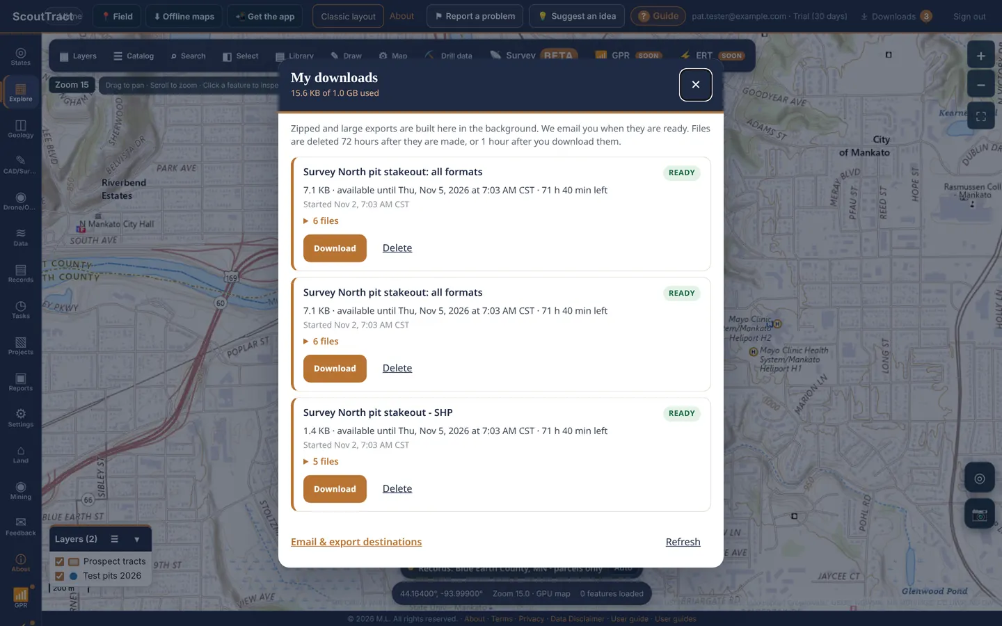
Files are deleted 72 hours after they are made, or 1 hour after you download them. Your downloads space is shown at the top (for example 15.6 KB of 1.0 GB used).
Email and export destinations
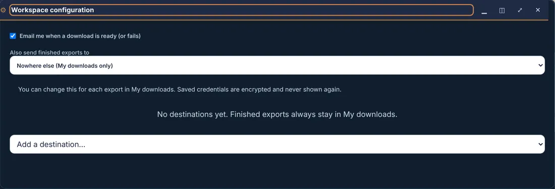
Open Settings → Downloads & export destinations (or Email & export destinations at the bottom of My downloads).
- Email me when a download is ready (or fails).
- Also send finished exports to: My downloads only, or a destination you add: an alternate email, S3-compatible storage (AWS, Backblaze B2, Wasabi, Cloudflare R2, DigitalOcean Spaces), Dropbox, or Google Drive (service account). You can change it for each export.
- Saved credentials are encrypted and never shown again. Finished exports always stay in My downloads too.
24 · Land, mining compliance and tasks
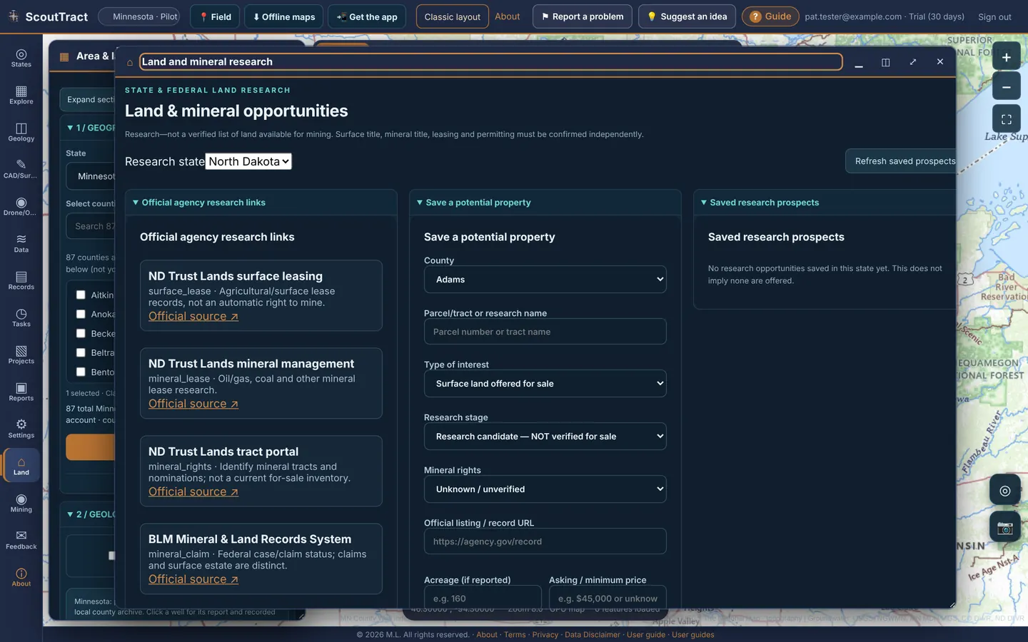
Land & mineral opportunities
Click Land in the left rail. A private research list of properties and tracts you are looking at. It is not a verified list of land for sale or for mining.
- Official agency research links for the research state: ND Trust Lands surface leasing, mineral management and the tract portal, the BLM Mineral & Land Records System, EPA ECHO, MSHA and ND DEQ incident resources.
- Save a potential property: county, parcel / tract or research name, type of interest, research stage, mineral rights, official listing URL, acreage, asking or minimum price, when the source was last checked, surface rights and mining permit status, then Save to my research.
- Saved research prospects and the Research prospect library: filter, Select all shown, and export the selection as CSV or PDF.
- Named prospect lists: Create list from selection or Add selected to list.
Mining compliance & incident screening
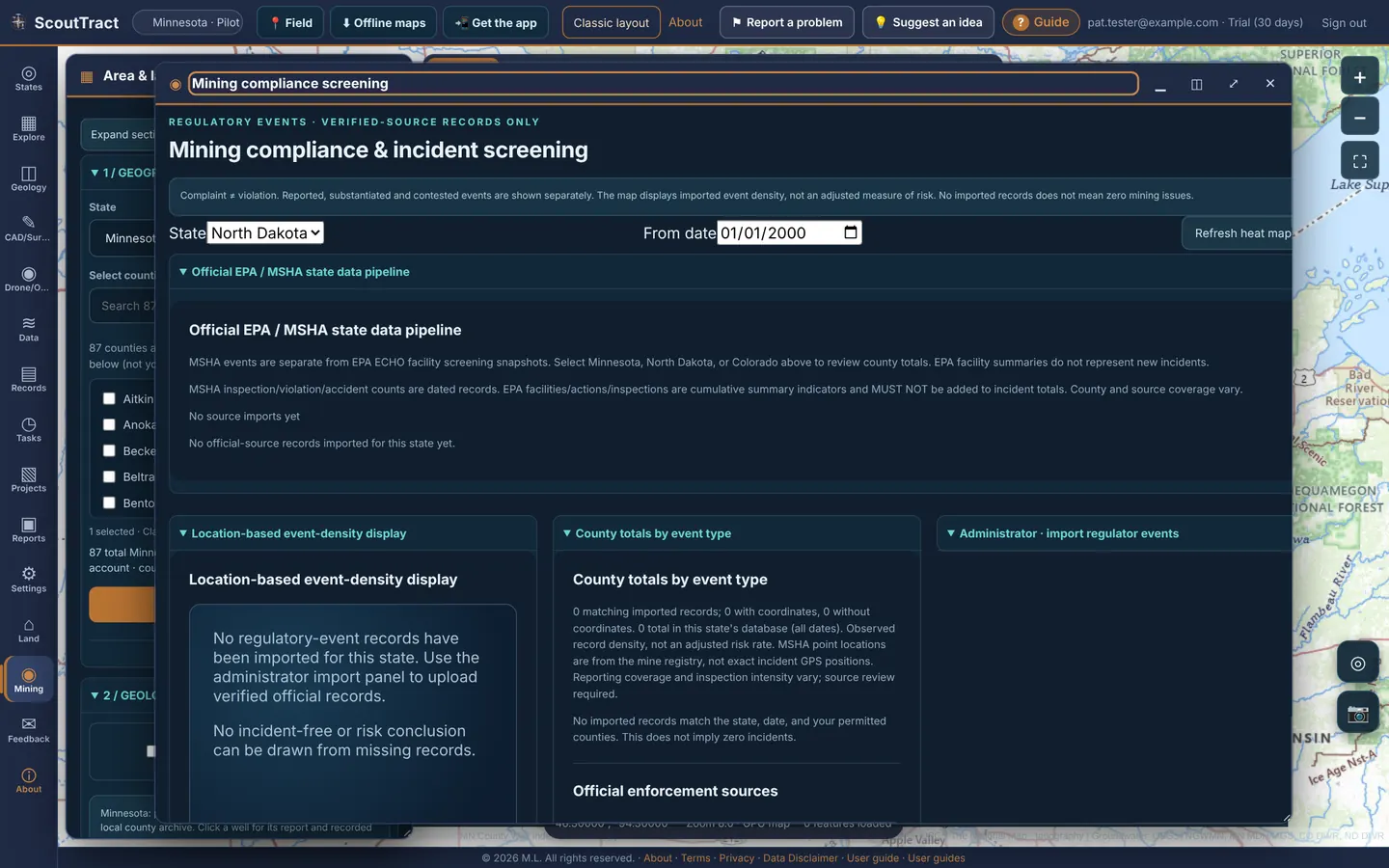
Click Mining in the left rail. Choose the state and a From date, then Refresh heat map. You see the official EPA / MSHA data pipeline status, a location-based event-density map, county totals by event type and links to the official enforcement sources.
Complaint ≠ violation. Reported, substantiated and contested events are shown separately, and the map shows imported event density, not a measure of risk. No imported records does not mean no mining issues.
Tasks & change monitoring
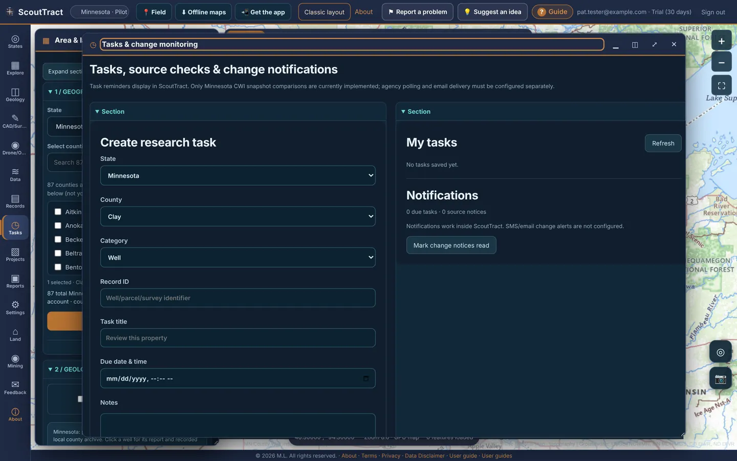
- Click Tasks in the left rail.
- Under Create research task choose state, county and category, and enter a record ID, task title, due date and time and notes. Tick Compare local MN CWI well record when checked to be told when a Minnesota well record changes.
- Click Save task. It appears under My tasks; due tasks and change notices show under Notifications (Mark change notices read).
You can also Create task for selected record from Records. Reminders show inside ScoutTract only.
25 · Drone/ODM
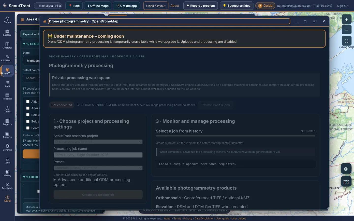
The Drone/ODM tab will process drone photos into orthophotos and elevation models with OpenDroneMap. It is under maintenance during the pilot and shows 🚧 Under maintenance – coming soon. Meanwhile you can upload a finished orthophoto or DEM GeoTIFF as your own layer (see Map layers).
26 · GPR and ERT add-ons (under construction)
Ground-penetrating radar (GPR) and electrical resistivity (ERT) processing are add-ons that are being built. Click GPR or ERT (marked Soon) in the map toolbar or the left rail. The panel explains what the add-on will do, the file formats it will read, and shows example images.
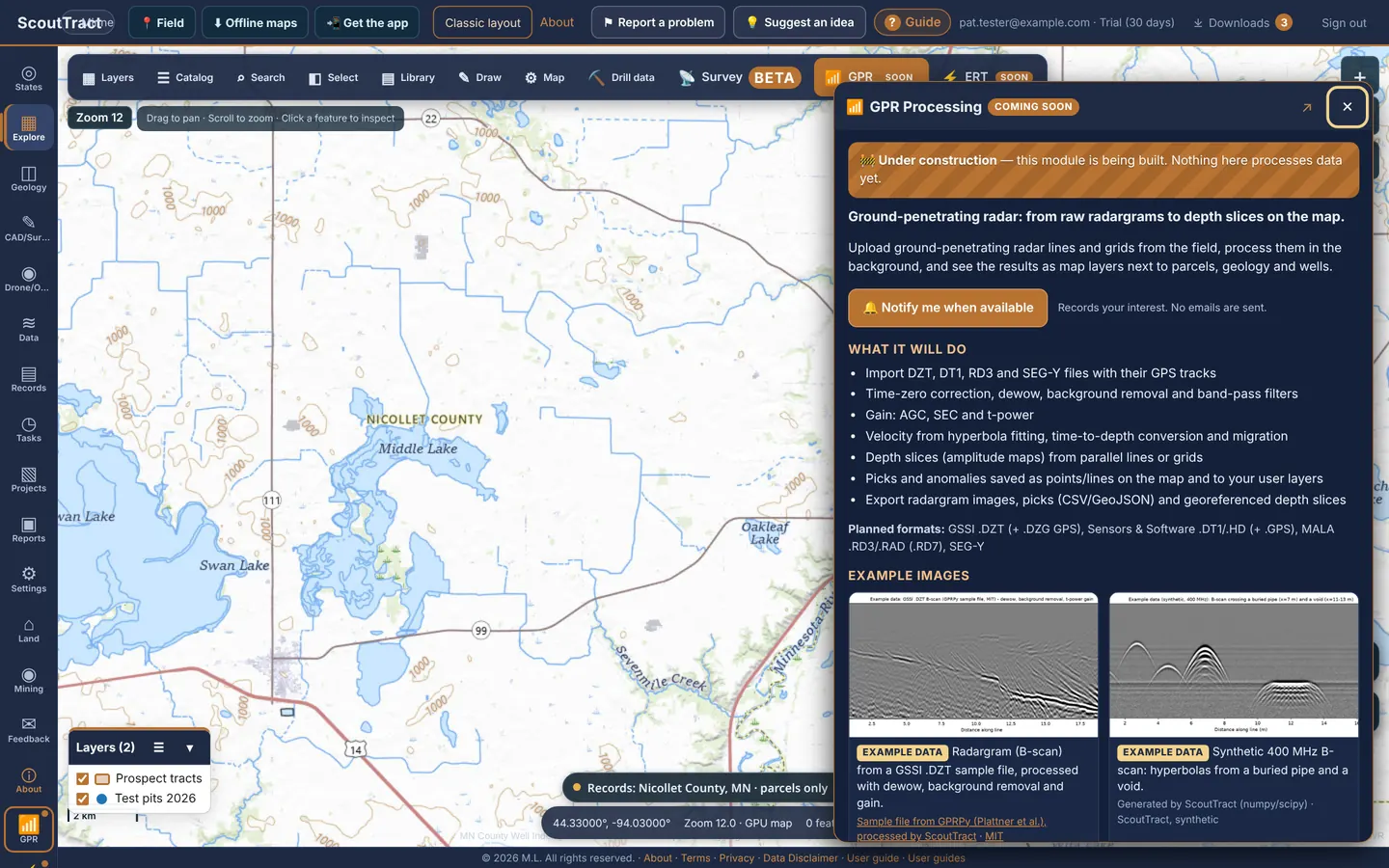
Nothing in these panels processes data yet. The example images are sample data, not your site.
- Click GPR. (or ERT).
- Click Notify me when available. Your interest is recorded so the team knows who wants it. No email is sent now.
27 · Survey (Beta) with an RTK receiver
Survey connects ScoutTract to an RTK GNSS receiver (Emlid Reach or Trimble) so you can collect points, stake out points and lines, run COGO and move files to and from Emlid Flow or Trimble Access. It is in Beta: check in on a known control point before relying on results.
To open it: click 📡 Survey on the map bar.
- Project: a State Plane zone (NAD83(2011)) or UTM/WGS84, and units.
- Connect: choose the receiver source, pick your Receiver model and enter the pole height to the bottom of the receiver (ARP), then press Start. ScoutTract adds that model’s NGS antenna phase-centre offset where the stream needs it; without a model, elevations read too high. The status bar shows fix, accuracy, satellites and PDOP.
- Trimble (TMM): leave Trimble Mobile Manager’s Apply antenna height off and enter the height in ScoutTract. If you prefer TMM to apply it, tick Antenna height already applied here instead, never both. Emlid RS3 / RS4 with tilt: set the height in Emlid Flow only and tick Tilt compensation on.
- FIX confirm: Android mock location (Lefebure, TMM) does not report fix status, so once per session check the receiver app shows FIX and click FIX confirmed.
- Collect: start with Check in on known point on a stored control point (default tolerance 0.05 m horizontal, 0.08 m vertical) to prove the antenna height, geoid and corrections, and download the check-in report (Download check-in report (CSV)). Then wait for RTK fixed and ≤ 5 cm and measure.
- Stakeout, COGO, Points/Files (CSV, DXF, shapefile, KML, JobXML) and OPUS.
The full step-by-step guide with receiver setup, antenna height, stakeout, exports and checklists is the GPS field guide: Survey (Beta) (Desktop edition, PDF).
28 · Inviting someone to a free trial
Full accounts can invite colleagues to a private 30-day trial. Click ✉️ Invite in the left rail or the top bar. Trial accounts do not get the Invite button.
- Enter Their name and Email (optional). A Mobile number is accepted, but text invites are paused until carrier approval, so use email.
- Add an optional Note (included in the email) or tick Don’t send anything — just create the link for me to copy.
- Click Create invitation.
The link is single-use and expires after 14 days. No payment details are needed, and their access never goes beyond your own state permissions. The dialog shows how many invitations you have left (normally 10 in any 30 days) and there is one free trial per email address and phone number. My invitations lists each one with Copy link and Revoke.
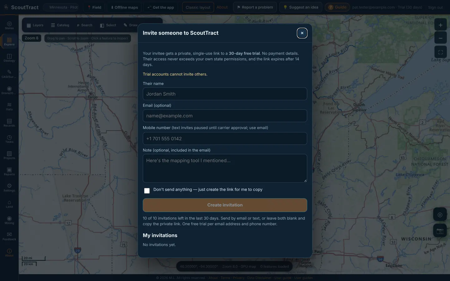
Settings also has Share a 30-day trial invitation, which opens the same dialog.
29 · Settings, password and account
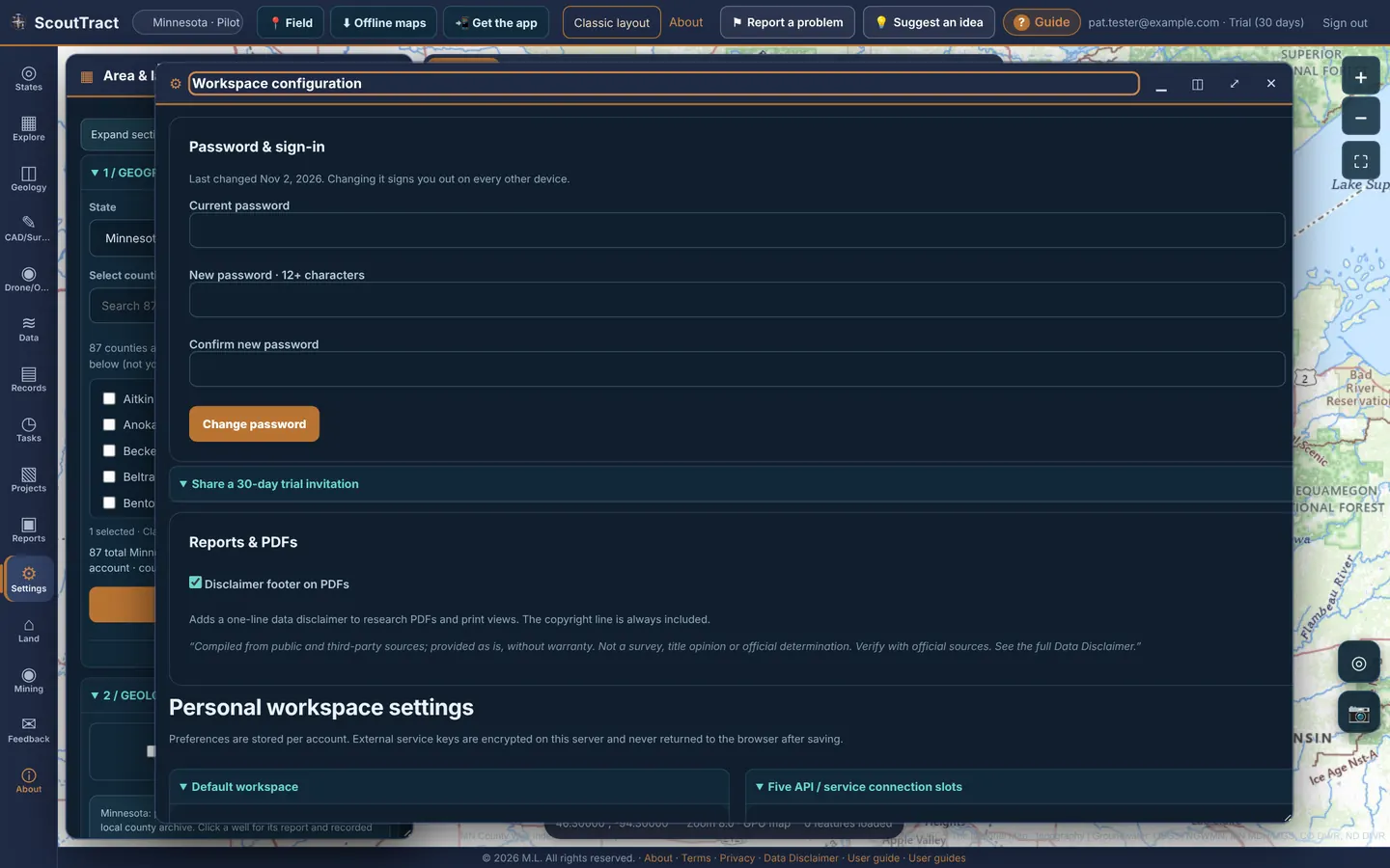
Click Settings in the left rail. (Workspace configuration).
Change your password
- Under Password & sign-in, enter your current password and a new one of 12 or more characters, twice.
- Click Change password. You stay signed in here; every other device is signed out.
Forgot it? Use Forgot password? on the sign-in page (see Getting in).
Other settings
| Setting | What it does |
|---|---|
| Reports & PDFs | Disclaimer footer on PDFs adds a one-line data disclaimer to research PDFs and print views (an administrator can require it) |
| Personal workspace settings | Default state and county, geology units (feet or metres), basemap / street-map / aerial preference, Opening page (State selection, Explore map or Projects), map zoom and Viewer mode (Map-first or Split viewer). Save preferences |
| Five API / service connection slots | Store a key for an outside provider. Keys are encrypted on the server and never shown again; saving does not test the connection |
| Brand your reports | Company / brand name and a PNG or JPG logo (1 MB max) for the header of your parcel research PDFs. Tick Show my branding on report PDFs, then Save report branding; Remove logo takes it off |
| Second-factor readiness | Phone verification for a future second sign-in step. Optional, and not working yet during the pilot (see Known limits) |
Sign out: Sign out at the top right. About shows the version and the legal documents (Terms of Service, Privacy Policy, Data Disclaimer), which are also linked at the foot of every page.
30 · Safety: SOS, emergency contacts and medical info
Coming soon: emergency contact texting is being turned on shortly. Email alerts to confirmed emergency contacts work now.
Always call 911 first in an emergency. ScoutTract does not call 911 or dispatch help, and it is not a substitute for 911. Alerts need a cell or data signal, location permission and battery; phone sensors can also raise false alerts, and email can be delayed or blocked. Keep a separate emergency plan.
Add emergency contacts (optional)
- Open Settings / Account › Emergency contacts. Add up to three contacts: name and mobile number, plus an email address. Email alerts need an email address on the contact.
- Only add someone who has agreed to be your contact, and tick the box to confirm it.
- Tap Create private confirmation link and send the link to that person yourself (text, email, in person). ScoutTract does not message them first. They open it, read the consent text, tick I agree and press Confirm; opening the link alone confirms nothing. Links work once and expire after 24 hours.
- Only a Confirmed contact gets alerts. Changing a contact’s phone or email needs a fresh confirmation. Contacts who confirmed under the older text-reply process need to confirm again with a new link.
SOS and crash/fall alerts
- With a hunting party open, the red SOS button sends your message and current or last known GPS position to everyone in the party.
- An SOS, or a crash/fall alert you don’t cancel during its countdown, also emails each confirmed emergency contact who has an email address: your name, the time (Central Time), your location or “unavailable”, and a private live link. Texts to contacts are coming soon; until then contacts are not texted.
- The private link shows only this incident: your current or last known position and its time, up to the last hour of trail, battery if known, Directions, and medical info only if you share it. Contacts should not forward it.
- Tap I’m OK (or I’m safe for a crash/fall alert) to end it. Location updates stop and the page shows Ended; it expires 24 hours later. Emails already sent cannot be recalled, so tell your contacts directly that you are safe.
Medical info (optional)
- In Settings you can save medications, allergies, prescriptions and a note. They are encrypted at rest and only you can view or edit them in the app; administrators have no medical viewer.
- Share medical info with my emergency contacts during SOS turns on when you first enter information. Switch it off before saving if you don’t want to share. When on, confirmed contacts see it on the private SOS link; the alert itself only says medical info is on the link.
If you receive a ScoutTract alert
Try to reach the sender. Check the time on the location. Call 911 if you cannot reach them and believe there is an emergency. Do not forward or post the private link.
31 · Signed-in devices and new-device alerts
Open Settings → Signed-in devices to see every browser and phone signed in to your account: the device, browser, when it signed in, when it was last active and its IP address. This device marks the one you are using; New device marks a recent first sign-in.
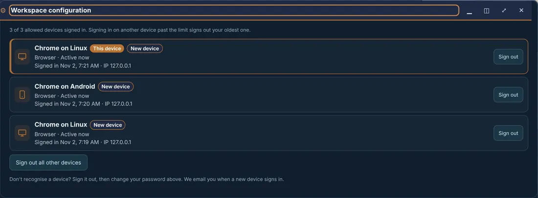
- Sign out one device, or Sign out all other devices.
- Device limit: you can be signed in on 3 devices at once. Signing in on a fourth signs out your oldest session, and ScoutTract tells you which one.
- New-device alerts: when your account signs in on a device it has not seen before, you get an email. If it wasn't you, sign that device out here and change your password.
- A link to /#devices, as in the alert email, opens this card directly.
Don't share your login. Each person needs their own invitation, and a shared login keeps signing the other person out.
32 · Feedback: report a problem or suggest an idea
Your feedback shapes the pilot, and every report goes straight to the ScoutTract team with your map position attached.
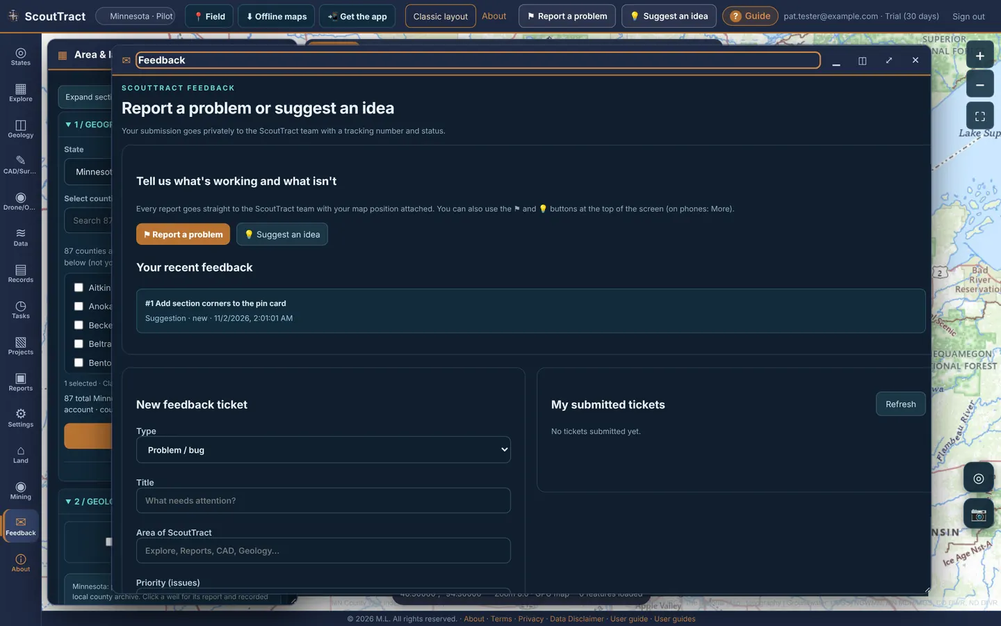
- Click ⚑ Report a problem or 💡 Suggest an idea in the top bar.
- Choose Problem or Suggestion, give a short title and a description, and say how bad it is (Blocker, Annoying or Minor).
- Leave Include a screenshot of the map ticked if it helps, then click Send.
The Feedback page (Feedback in the left rail) shows Your recent feedback and has a fuller New feedback ticket form (type, title, area of ScoutTract, priority, details, Submit ticket) and My submitted tickets with their status.
You can also email catchall@scouttract.com. Helpful details: the state and place, what you did, what you expected and what happened.
33 · Administration (administrators only)
This chapter is for ScoutTract administrators only. Other accounts never see these controls.
Click ♙ Admin at the bottom of the left rail. The Administration and access page is one long page of cards.
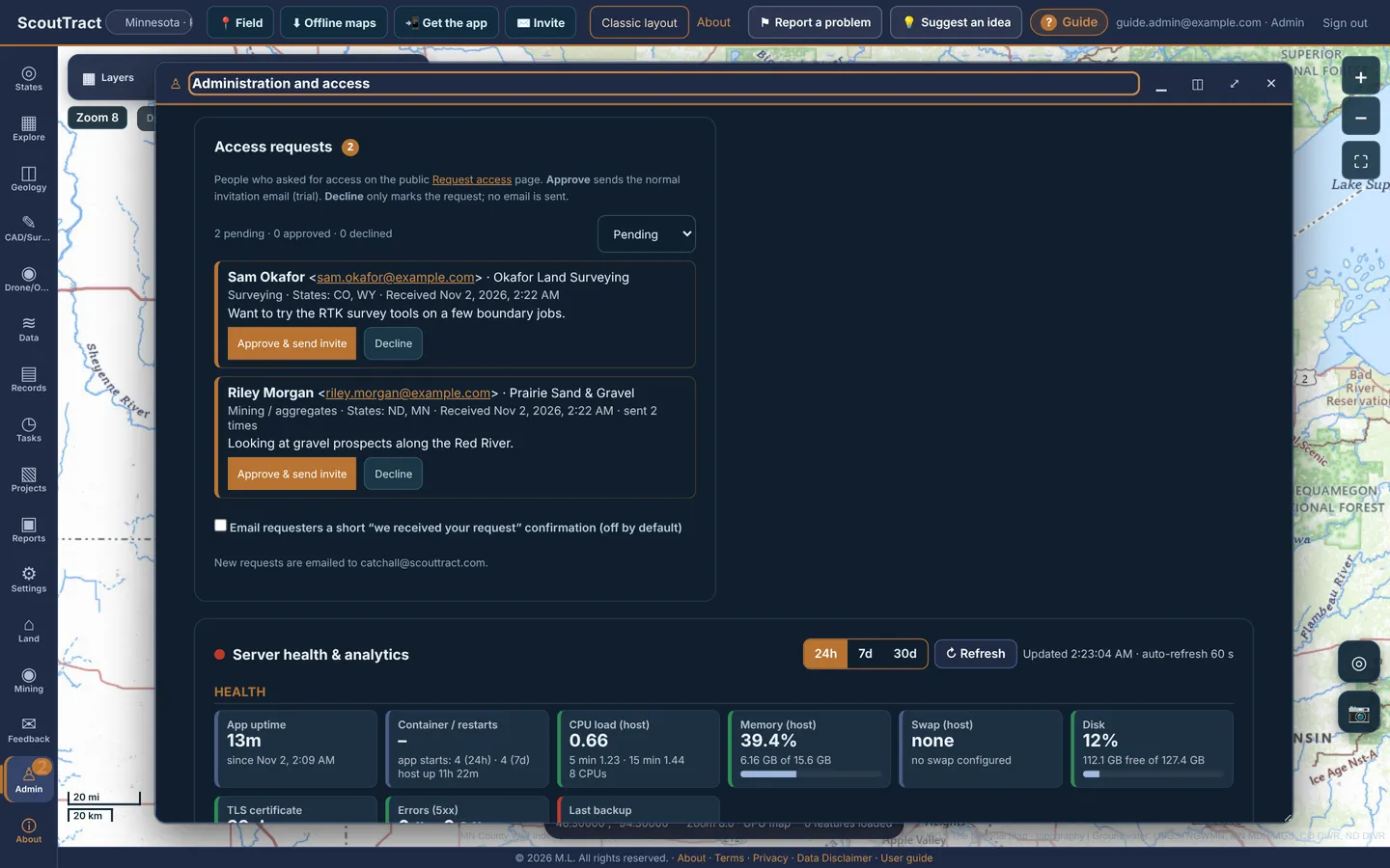
Access requests
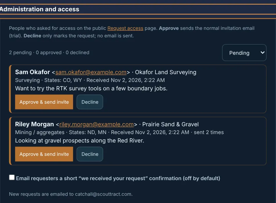
People who asked on the public Request access page. Approve & send invite sends the normal trial invitation; Decline only marks the request (no email). Filter Pending / Approved / Declined / All. Optional: email requesters a short “we received your request” confirmation (off by default). New requests are also emailed to catchall@scouttract.com.
Server health & analytics
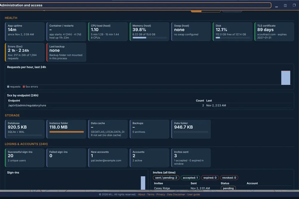
24h / 7d / 30d, auto-refresh every 60 s. Health (uptime, restarts, CPU, memory, swap, disk, TLS certificate, 5xx errors, last backup), storage, sign-ins and accounts, invites, data served versus pulled from outside sources, cache hit rate by source, top endpoints / layers / states / counties, per-user activity, owner-name search counts (names are not stored) and feedback totals.
Invites & trials
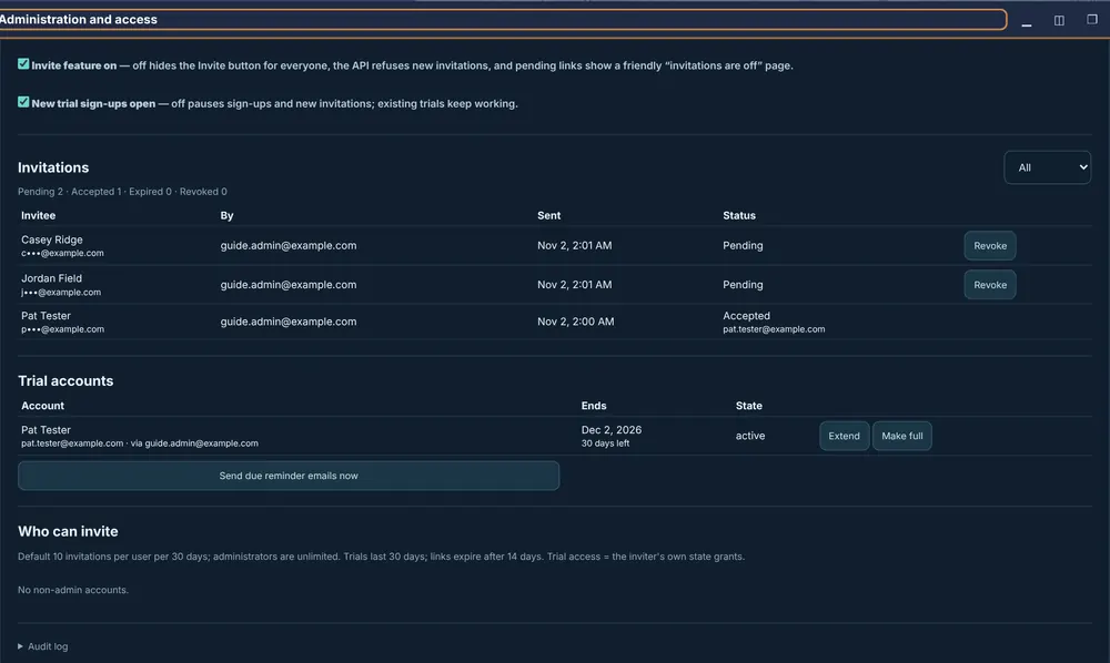
Switches: Invite feature on and New trial sign-ups open. Lists all invitations (Revoke a pending one), trial accounts (Extend, Make full), Send due reminder emails now, Who can invite (default 10 per user per 30 days; administrators unlimited) and an audit log.
Trial access & research and usage analytics
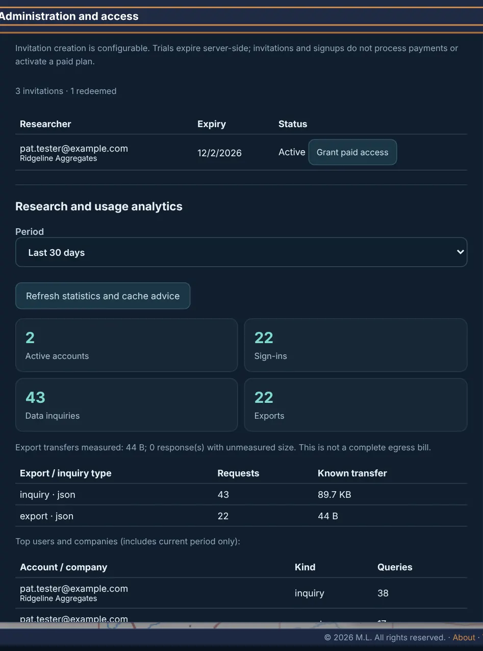
Trial expiry per researcher with Grant paid access; active accounts, sign-ins, data inquiries and exports by period; top users and companies; dataset cache recommendations.
Local dataset manager
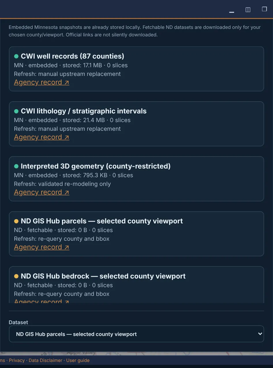
Embedded and fetchable datasets with size and refresh method. Download a county viewport slice for a dataset, Update all downloaded slices, and see cached regions, usage and disk inventory. Assign user’s company for the analytics.
Account permissions
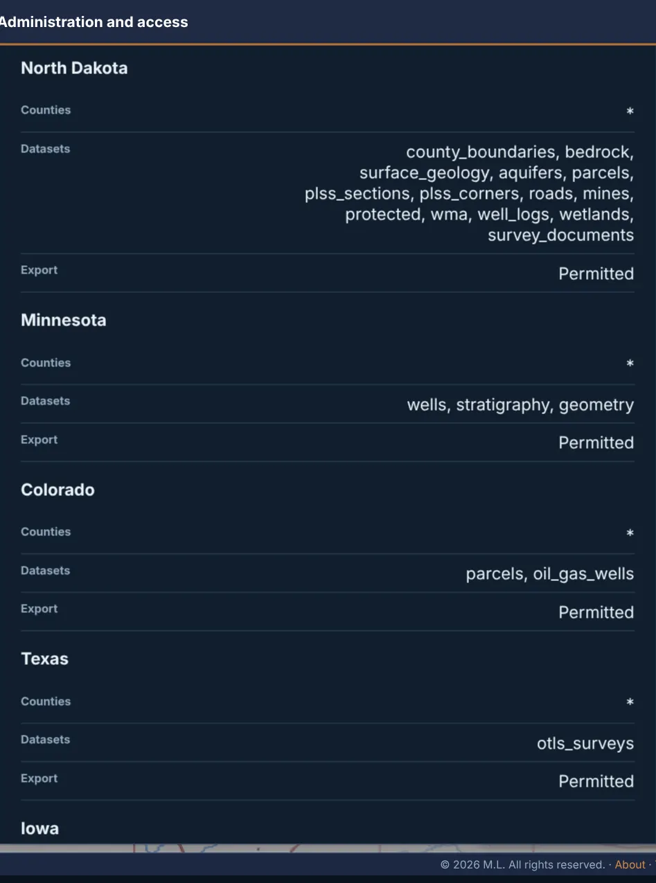
Per account and state: allowed counties, datasets and whether export is permitted.
Zoning PDF → map layer and Grant an account
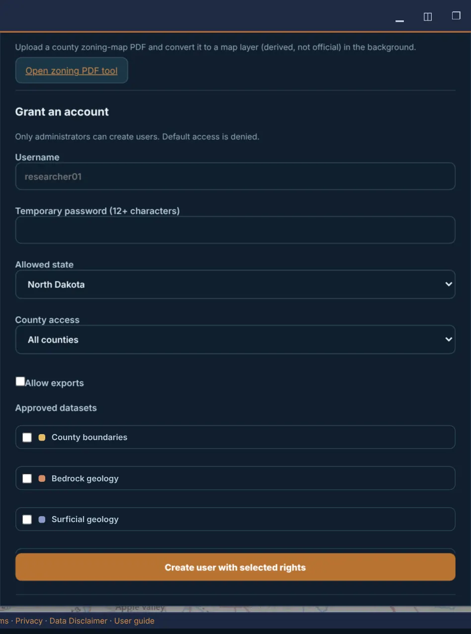
Open zoning PDF tool converts a county zoning-map PDF into a (derived, not official) map layer in the background. Grant an account: username, temporary password (12+ characters), allowed state, county access, Allow exports and approved datasets, then Create user with selected rights. The Accounts list lets you Disable an account.
MFA, database and diagnostics
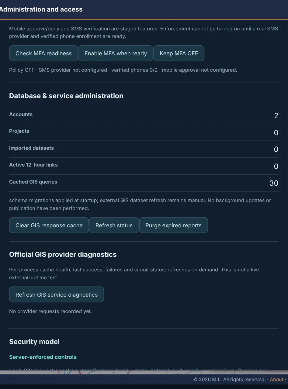
MFA administration (OFF by default; needs the SMS provider). Database & service administration: Clear GIS response cache, Refresh status, Purge expired reports. Official GIS provider diagnostics and the Security model summary.
Branding & About
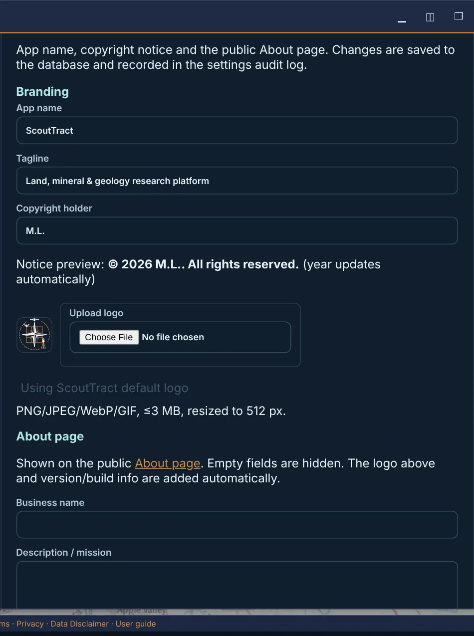
App name, tagline, copyright holder and logo (PNG/JPEG/WebP/GIF, 3 MB max); the public About page fields (business name, mission, contact, social links). Save branding & About; changes go to the settings audit log.
PDF disclaimer footer
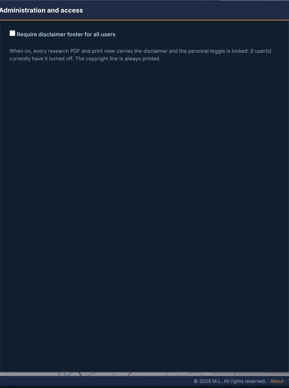
Require disclaimer footer for all users forces the one-line disclaimer onto every research PDF and print view.
Legal documents & acceptance
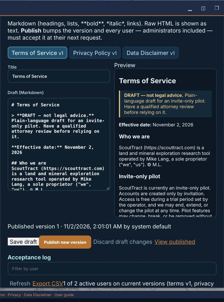
Edit the Terms of Service, Privacy Policy and Data Disclaimer as Markdown with a live preview. Save draft, Publish new version (every user must accept it at their next request), Discard draft changes, View published. The Acceptance log shows who accepted which version, with Export CSV.
Tester feedback
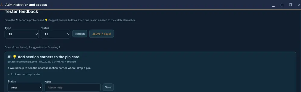
Everything sent with ⚑ Report a problem and 💡 Suggest an idea. Each one is also emailed to the catch-all mailbox.
Issue & suggestion administration
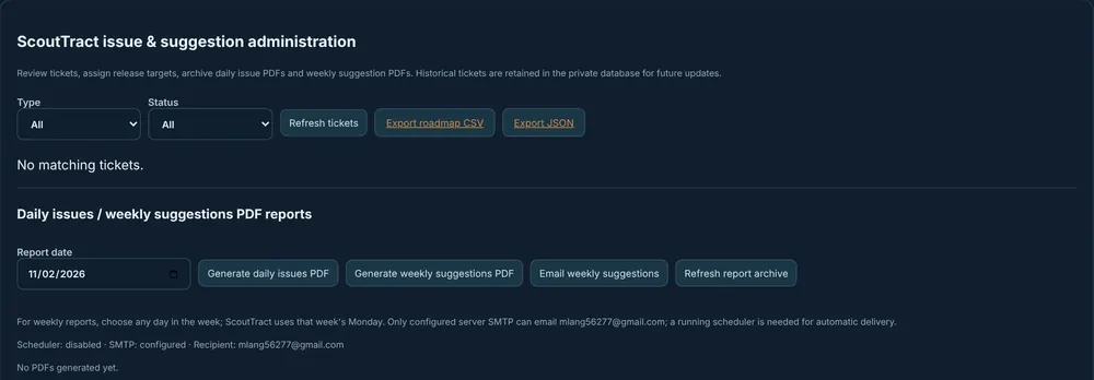
Tickets from the Feedback page: filter by type and status (Open, Reviewing, Planned, In progress, Resolved, Declined), Refresh tickets, assign release targets, Export roadmap CSV / Export JSON, and the daily issues / weekly suggestions PDF reports.
Approving a request or creating an invitation sends email to that person. Check the address first.
34 · Known limits during the pilot
- Drone/ODM processing is under maintenance.
- The GPR and ERT add-on tabs are under construction; Drill data is in Beta (see Add-on tabs and Drill data).
- Text messages (SMS) are not set up yet: no second sign-in factor, no phone verification and no text invitations or text-the-link. Use email.
- Tasks change monitoring covers Minnesota CWI well records only, and reminders show inside ScoutTract only.
- Owner search covers only counties that publish owner names in free public data: 45 of 87 in Minnesota plus Scott County, 41 of 64 in Colorado, Douglas and Lancaster in Nebraska, and none in Texas (North Dakota, Montana, Wyoming and North Carolina are statewide; Alleghany and Clay counties publish no NC mailing addresses). The county list marks the rest not available (see Search).
- Records Google Drive storage needs a separate Google authorization on the server; packages are kept in ScoutTract storage until then.
- The optional MLightCAD drawing editor may not be installed on every server.
- Every result is research from public sources. It is not a survey, title opinion or official determination.
35 · Terms, privacy and data disclaimer
Using ScoutTract means accepting the Terms of Service, the Privacy Policy and the Data Disclaimer. When a document changes, you are asked to accept the new version before you continue.
Data is compiled from public and third-party sources and provided as is, without warranty. It is not a survey, title opinion or official determination. Verify with official sources before relying on it.
Questions or problems: catchall@scouttract.com. © 2026 M.L. All rights reserved.